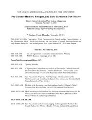
PREFACE
Southeastern New Mexico Regional Research Design and ...
Southeastern New Mexico Regional Research Design and ...
- No tags were found...

You also want an ePaper? Increase the reach of your titles
YUMPU automatically turns print PDFs into web optimized ePapers that Google loves.
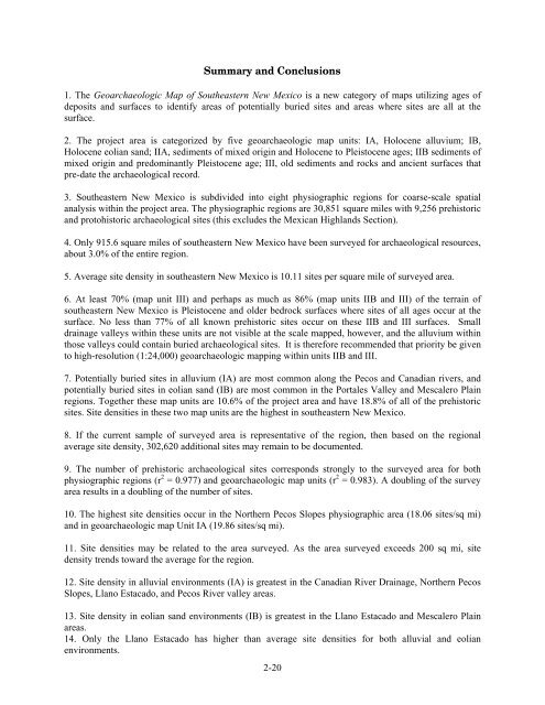
Summary and Conclusions1. The Geoarchaeologic Map of Southeastern New Mexico is a new category of maps utilizing ages ofdeposits and surfaces to identify areas of potentially buried sites and areas where sites are all at thesurface.2. The project area is categorized by five geoarchaeologic map units: IA, Holocene alluvium; IB,Holocene eolian sand; IIA, sediments of mixed origin and Holocene to Pleistocene ages; IIB sediments ofmixed origin and predominantly Pleistocene age; III, old sediments and rocks and ancient surfaces thatpre-date the archaeological record.3. Southeastern New Mexico is subdivided into eight physiographic regions for coarse-scale spatialanalysis within the project area. The physiographic regions are 30,851 square miles with 9,256 prehistoricand protohistoric archaeological sites (this excludes the Mexican Highlands Section).4. Only 915.6 square miles of southeastern New Mexico have been surveyed for archaeological resources,about 3.0% of the entire region.5. Average site density in southeastern New Mexico is 10.11 sites per square mile of surveyed area.6. At least 70% (map unit III) and perhaps as much as 86% (map units IIB and III) of the terrain ofsoutheastern New Mexico is Pleistocene and older bedrock surfaces where sites of all ages occur at thesurface. No less than 77% of all known prehistoric sites occur on these IIB and III surfaces. Smalldrainage valleys within these units are not visible at the scale mapped, however, and the alluvium withinthose valleys could contain buried archaeological sites. It is therefore recommended that priority be givento high-resolution (1:24,000) geoarchaeologic mapping within units IIB and III.7. Potentially buried sites in alluvium (IA) are most common along the Pecos and Canadian rivers, andpotentially buried sites in eolian sand (IB) are most common in the Portales Valley and Mescalero Plainregions. Together these map units are 10.6% of the project area and have 18.8% of all of the prehistoricsites. Site densities in these two map units are the highest in southeastern New Mexico.8. If the current sample of surveyed area is representative of the region, then based on the regionalaverage site density, 302,620 additional sites may remain to be documented.9. The number of prehistoric archaeological sites corresponds strongly to the surveyed area for bothphysiographic regions (r 2 = 0.977) and geoarchaeologic map units (r 2 = 0.983). A doubling of the surveyarea results in a doubling of the number of sites.10. The highest site densities occur in the Northern Pecos Slopes physiographic area (18.06 sites/sq mi)and in geoarchaeologic map Unit IA (19.86 sites/sq mi).11. Site densities may be related to the area surveyed. As the area surveyed exceeds 200 sq mi, sitedensity trends toward the average for the region.12. Site density in alluvial environments (IA) is greatest in the Canadian River Drainage, Northern PecosSlopes, Llano Estacado, and Pecos River valley areas.13. Site density in eolian sand environments (IB) is greatest in the Llano Estacado and Mescalero Plainareas.14. Only the Llano Estacado has higher than average site densities for both alluvial and eolianenvironments.2-20