Lake Ellyn Park 2013 Master Plan
Lake Ellyn Master Plan Final - Glen Ellyn Park District
Lake Ellyn Master Plan Final - Glen Ellyn Park District
- No tags were found...

Create successful ePaper yourself
Turn your PDF publications into a flip-book with our unique Google optimized e-Paper software.
2. site analysis & existing conditions<br />
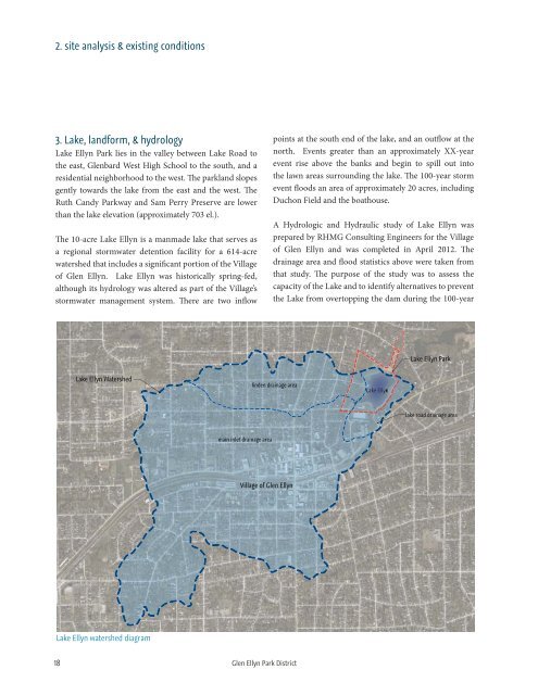
3. <strong>Lake</strong>, landform, & hydrology<br />
<strong>Lake</strong> <strong>Ellyn</strong> <strong>Park</strong> lies in the valley between <strong>Lake</strong> Road to<br />
the east, Glenbard West High School to the south, and a<br />
residential neighborhood to the west. The parkland slopes<br />
gently towards the lake from the east and the west. The<br />
Ruth Candy <strong>Park</strong>way and Sam Perry Preserve are lower<br />
than the lake elevation (approximately 703 el.).<br />
The 10-acre <strong>Lake</strong> <strong>Ellyn</strong> is a manmade lake that serves as<br />
a regional stormwater detention facility for a 614-acre<br />
watershed that includes a significant portion of the Village<br />
of Glen <strong>Ellyn</strong>. <strong>Lake</strong> <strong>Ellyn</strong> was historically spring-fed,<br />
although its hydrology was altered as part of the Village’s<br />
stormwater management system. There are two inflow<br />
points at the south end of the lake, and an outflow at the<br />
north. Events greater than an approximately XX-year<br />
event rise above the banks and begin to spill out into<br />
the lawn areas surrounding the lake. The 100-year storm<br />
event floods an area of approximately 20 acres, including<br />
Duchon Field and the boathouse.<br />
A Hydrologic and Hydraulic study of <strong>Lake</strong> <strong>Ellyn</strong> was<br />
prepared by RHMG Consulting Engineers for the Village<br />
of Glen <strong>Ellyn</strong> and was completed in April 2012. The<br />
drainage area and flood statistics above were taken from<br />
that study. The purpose of the study was to assess the<br />
capacity of the <strong>Lake</strong> and to identify alternatives to prevent<br />
the <strong>Lake</strong> from overtopping the dam during the 100-year<br />
<strong>Lake</strong> <strong>Ellyn</strong> <strong>Park</strong><br />
<strong>Lake</strong> <strong>Ellyn</strong> Watershed<br />
linden drainage area<br />
<strong>Lake</strong> <strong>Ellyn</strong><br />
lyn<br />
lake road drainage area<br />
main inlet drainage area<br />
Village of Glen <strong>Ellyn</strong><br />
<strong>Lake</strong> <strong>Ellyn</strong> watershed diagram<br />
18 Glen <strong>Ellyn</strong> <strong>Park</strong> District