

peru-8-cuzco-sacred-valley

You also want an ePaper? Increase the reach of your titles
YUMPU automatically turns print PDFs into web optimized ePapers that Google loves.
256<br />
The Inca Trail<br />
The most famous hike in South America,<br />
the four-day Inca Trail, is walked by thousands<br />
every year. Although the total distance<br />
is only about 24 miles, the ancient<br />
trail laid by the Incas from the Sacred Valley<br />
to Machu Picchu winds its way up and<br />
down and around the mountains, snaking<br />
over three high Andean passes en route,<br />
which have collectively led to the route<br />
being dubbed ‘the Inca Trial.’ The views of<br />
snowy mountain peaks, distant rivers and<br />
ranges, and cloud forests flush with orchids<br />
are stupendous – and walking from<br />
one cliff-hugging pre-Columbian ruin to<br />
the next is a mystical and unforgettable<br />
experience.<br />
For information on trekking an alternative<br />
route, see p38.<br />
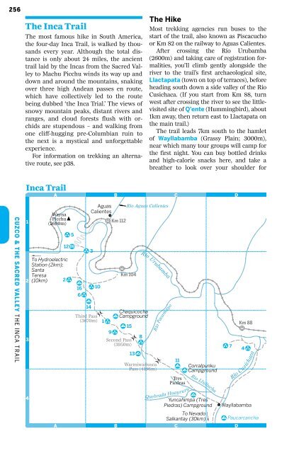
The Hike<br />
Most trekking agencies run buses to the<br />
start of the trail, also known as Piscacucho<br />
or Km 82 on the railway to Aguas Calientes.<br />
After crossing the Río Urubamba<br />
(2600m) and taking care of registration formalities,<br />
you’ll climb gently alongside the<br />
river to the trail’s first archaeological site,<br />
Llactapata (town on top of terraces), before<br />
heading south down a side <strong>valley</strong> of the Río<br />
Cusichaca. (If you start from Km 88, turn<br />
west after crossing the river to see the littlevisited<br />
site of Q’ente (Hummingbird), about<br />
1km away, then return east to Llactapata on<br />
the main trail.)<br />
The trail leads 7km south to the hamlet<br />
of Wayllabamba (Grassy Plain; 3000m),<br />
near which many tour groups will camp for<br />
the first night. You can buy bottled drinks<br />
and high-calorie snacks here, and take a<br />
breather to look over your shoulder for<br />
Inca Trail<br />
A<br />
B<br />
C<br />
D<br />
Cuzco & the Sacred Valley M T H AC E H I N U I K C P E A I C T C R H A I U L & T H E I N C A T R A I L<br />
1<br />
2<br />
3<br />
4<br />
Wayna<br />
PicchuR<br />
(2690m)<br />
ä#<br />
5<br />
12 #ÿ<br />
‚<br />
To Hydroelectric<br />
Station (2km);<br />
Santa<br />
Teresa<br />
(10km)<br />
A<br />
2 ä#<br />
ä#<br />
3<br />
Aguas Río Aguas Calientes<br />
Calientes<br />
\#<br />
£ # Km 112<br />
£ #<br />
Km 104<br />
S#<br />
16 ä#<br />
10<br />
6ä#<br />
S#<br />
14<br />
Chaquicocha<br />
Third Pass S#<br />
Campground<br />
(3670m) 1 ä#<br />
S#<br />
15<br />
9 ä#<br />
8<br />
Second Pass ä#<br />
(3950m)<br />
13 S#<br />
c<br />
B<br />
c<br />
Río Urubamba<br />
c<br />
Warmiwañusca<br />
Pass (4198m)<br />
Río Pacamayo<br />
11<br />
S#<br />
Corralpunku<br />
S#<br />
Campground<br />
Tres<br />
Piedras<br />
S#<br />
Yuncahimpa (Tres<br />
Piedras) Campground<br />
To Nevado<br />
Salkantay (30km)<br />
Quebrada Huayruru<br />
C<br />
Río Llullucha<br />
‚<br />
#\<br />
ä#<br />
7<br />
Km 88<br />
£ #<br />
4 ä#<br />
Río Cusichaca<br />
Wayllabamba<br />
S#<br />
Paucarcancha<br />
D