

peru-8-cuzco-sacred-valley

Create successful ePaper yourself
Turn your PDF publications into a flip-book with our unique Google optimized e-Paper software.
views of the snowcapped Nevado Verónica<br />
(5750m).<br />
Wayllabamba is situated near the fork<br />
of Ríos Llullucha and Cusichaca. The trail<br />
crosses the Río Llullucha, then climbs steeply<br />
up along the river. This area is known as<br />
Tres Piedras (Three White Stones/3300m),<br />
though these boulders are no longer visible.<br />
From here it is a long, very steep 3km climb<br />
through humid woodlands.<br />
The trail eventually emerges on the high,<br />
bare mountainside of Llulluchupampa<br />
(3750m), where water is available and the<br />
flats are dotted with campsites, which get<br />
very cold at night. This is as far as you can<br />
reasonably expect to get on your first day,<br />
though many groups will actually spend<br />
their second night here.<br />
From Llulluchupampa, a good path up<br />
the left-hand side of the <strong>valley</strong> climbs for<br />
a two- to three-hour ascent to the pass of<br />
Warmiwañusca, also colorfully known as<br />
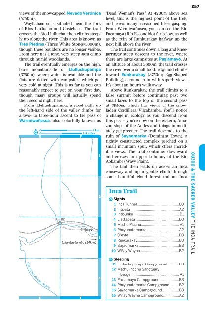
#e<br />
05 km<br />
0 2.5 miles<br />
E<br />
F<br />
Quebrada Sauquchayoc<br />
E<br />
Km 82<br />
#£<br />
Chilca<br />
3<br />
Ollantaytambo (14km)<br />
F<br />
#\<br />
‚<br />
1<br />
2<br />
4<br />
‘Dead Woman’s Pass.’ At 4200m above sea<br />
level, this is the highest point of the trek,<br />
and leaves many a seasoned hiker gasping.<br />
From Warmiwañusca, you can see the Río<br />
Pacamayo (Río Escondido) far below, as well<br />
as the ruin of Runkurakay halfway up the<br />
next hill, above the river.<br />
The trail continues down a long and kneejarringly<br />
steep descent to the river, where<br />
there are large campsites at Paq’amayo. At<br />
an altitude of about 3600m, the trail crosses<br />
the river over a small footbridge and climbs<br />
toward Runkurakay (3750m; Egg-Shaped<br />
Building), a round ruin with superb views.<br />
It’s about an hour’s walk away.<br />
Above Runkurakay, the trail climbs to a<br />
false summit before continuing past two<br />
small lakes to the top of the second pass<br />
at 3950m, which has views of the snowladen<br />
Cordillera Vilcabamba. You’ll notice<br />
a change in ecology as you descend from<br />
this pass – you’re now on the eastern, Amazon<br />
slope of the Andes and things immediately<br />
get greener. The trail descends to the<br />
ruin of Sayaqmarka (Dominant Town), a<br />
tightly constructed complex perched on a<br />
small mountain spur, which offers incredible<br />
views. The trail continues downward<br />
and crosses an upper tributary of the Río<br />
Aobamba (Wavy Plain).<br />
The trail then leads on across an Inca<br />
causeway and up a gentle climb through<br />
some beautiful cloud forest and an Inca<br />
Inca Trail<br />
æ Sights<br />
1 Inca Tunnel ............................................B3<br />
2 Intipata ...................................................A2<br />
3 Intipunku................................................ B1<br />
4 Llactapata..............................................D3<br />
5 Machu Picchu........................................ A1<br />
6 Phuyupatamarka ..................................A2<br />
7 Q'ente .....................................................D3<br />
8 Runkurakay............................................B3<br />
9 Sayaqmarka ..........................................B3<br />
10 Wiñay Wayna.........................................B2<br />
ÿ Sleeping<br />
11 Llulluchupampa Campground............C3<br />
12 Machu Picchu Sanctuary<br />
Lodge................................................... A1<br />
13 Paq'amayo Campground.....................B3<br />
14 Phuyupatamarka Campground..........B2<br />
15 Sayaqmarka Campground..................B3<br />
16 Wiñay Wayna Campground.................A2<br />
257<br />
Cuzco & the Sacred Valley M T H AC E H I N U I K C P E A I C T C R H A I U L & T H E I N C A T R A I L