NATIONAL REPORT OF THE FEDERAL REPUBLIC OF ... - IAG Office
NATIONAL REPORT OF THE FEDERAL REPUBLIC OF ... - IAG Office
NATIONAL REPORT OF THE FEDERAL REPUBLIC OF ... - IAG Office
Create successful ePaper yourself
Turn your PDF publications into a flip-book with our unique Google optimized e-Paper software.
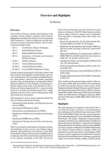
Overview<br />
The activities of German scientists and institutions in the<br />
scientific research related to reference frames shall be<br />
highlighted according to the structure of the corresponding<br />
<strong>IAG</strong> Commission 1, which is divided into four Sub-commissions,<br />
two Inter-commission Projects, and two Intercommission<br />
Study Groups:<br />
– SC1.1 Coordination of Space Techniques,<br />
– SC1.2 Global Reference Frames,<br />
– SC1.3 Regional Reference Frames,<br />
– SC1.4 Interaction of Celestial and Terrestrial<br />
Reference Frames,<br />
– IC-P1.1 Satellite Altimetry,<br />
– IC-P1.2 Vertical Reference Frames,<br />
– IC-SG1.1 Vertical Reference Frames,<br />
– IC-SG1.2 Use of GNSS for Reference Frames.<br />
German scientists participated in all of these entities with<br />
basic research, developments of methodologies and software,<br />
and education. The investigations included theoretical,<br />
observational, analytical and product generating<br />
activities. They also held positions as Commission officers:<br />
HERMANN DREWES was the President of Commission 1,<br />
MARKUS ROTHACHER acted as the President of SC1.1,<br />
WOLFGANG BOSCH chaired the IC-P1.1, JOHANNES IHDE<br />
the IC-P1.2, and MICHAEL SCHMIDT the IC-SG1.1. Many<br />
scientists were active in the various working groups of the<br />
sub-commissions and projects.<br />
The Commission’s work is closely connected with the <strong>IAG</strong><br />
services dealing with reference frames:<br />
– International Earth Rotation and Reference Systems<br />
Service (IERS),<br />
– International GNSS Service (IGS),<br />
– International Laser Ranging Service (ILRS),<br />
– International VLBI Service for Geodesy and Astrometry<br />
(IVS),<br />
– International DORIS Service (IDS).<br />
– International Altimetry Service (IAS, under development).<br />
There was an intensive participation of German scientists<br />
and institutions in these services, also holding superior<br />
positions: BERND RICHTER as the Director of the IERS<br />
Central Bureau, MARKUS ROTHACHER as the IERS analysis<br />
coordinator, JOHN DOW as the President and GERD GENDT<br />
as the analysis coordinator of the IGS, WOLFGANG<br />
Overview and Highlights<br />
H. DREWES 1<br />
SCHLÜTER as the President and AXEL NOTHNAGEL as the<br />
analysis coordinator of the IVS. Other German scientists<br />
acted as chairs of Service’s analysis (AC), combination<br />
(CC), data (DC) or operating centres (OC) which were<br />
conducted by<br />
– Bayerische Kommission für die Internationale Erdmessung<br />
(BEK) in the IGS (AC for Europe),<br />
– Bundesamt für Kartographie und Geodäsie (BKG) in<br />
IGS (AC and DC for Europe), ILRS (AC), and IVS (DC<br />
and AC),<br />
– Deutsches Geodätisches Forschungsinstitut (DGFI) in<br />
IERS (ITRS CC), IGS (DC and AC for Latin America),<br />
ILRS (AC, CC and DC) and IVS (AC),<br />
– Geodätisches Institut, Universität Bonn, (GIUB) in IVS<br />
(AC, OC and correlator),<br />
– GeoForschungsZentrum Potsdam (GFZ) in IGS (AC)<br />
and ILRS (AC),<br />
– Institut für Erdmessung, Universität Hannover (IfE) in<br />
ILRS (LLR),<br />
– European Space Operations Centre (ESOC), Darmstadt,<br />
in IGS (AC).<br />
These institutions also operated a large number of observation<br />
stations (GPS, SLR and VLBI) for the maintenance<br />
of global and regional reference frames, above all the<br />
Fundamental Station Wettzell (Germany) and the Transportable<br />
Integrated Geodetic Observatory (TIGO) in Concepción<br />
(Chile) of BKG. Others are the SLR station in Potsdam<br />
(GFZ), the VLBI station in O’Higgins (Antarctica, BKG)<br />
and many GPS stations of BEK, BKG, DGFI, GFZ all over<br />
the world.<br />
Highlights<br />
The most important investigations in the field of SC1.1<br />
“Coordination of space techniques” were those done for<br />
the combination of the different observation types (GPS,<br />
SLR, VLBI, DORIS). Major activities were the participation<br />
in international projects, such as the IERS Combination<br />
Pilot Project. The project “Integration of space geodetic<br />
techniques as the basis for a Global Geodetic-Geophysical<br />
Observing System (GGOS-D)”, financed by the German<br />
Bundesministerium für Bildung und Forschung (BMBF)<br />
is to study a rigorous combination with different approaches<br />
and software. Exactly identical constants, models and<br />
parameters are used for the analysis in all techniques. Other<br />
projects were the comparison and combination of precise<br />
orbits derived from different space techniques, in particular<br />
studies in low Earth orbiting satellites (LEOS) and the<br />
1 Hermann Drewes: Deutsches Geodätisches Forschungsinstitut (DGFI), Alfons-Goppel-Str. 11, D-80539 München, Germany, Tel.<br />
+49 - 89 - 23031-1106, Fax +49 - 89 - 23031 1240, e-mail drewes@dgfi.badw.de<br />
9


