eTheses Repository - University of Birmingham
eTheses Repository - University of Birmingham
eTheses Repository - University of Birmingham

Create successful ePaper yourself
Turn your PDF publications into a flip-book with our unique Google optimized e-Paper software.
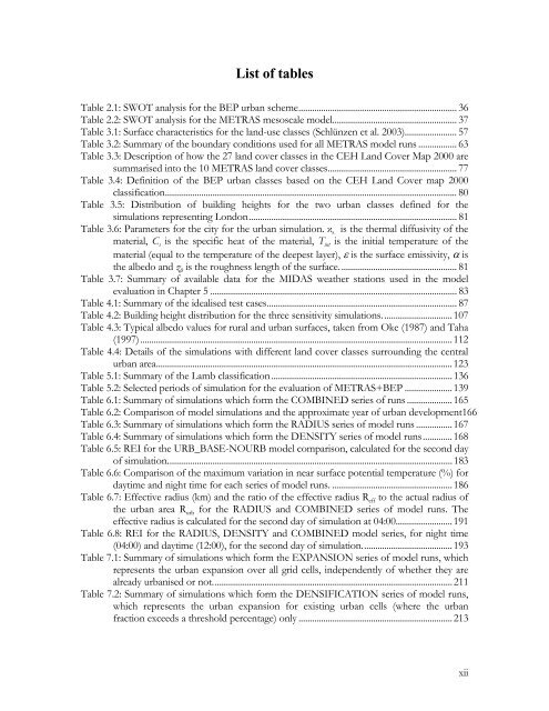
List <strong>of</strong> tables<br />
Table 2.1: SWOT analysis for the BEP urban scheme...................................................................... 36<br />
Table 2.2: SWOT analysis for the METRAS mesoscale model....................................................... 37<br />
Table 3.1: Surface characteristics for the land-use classes (Schlünzen et al. 2003)....................... 57<br />
Table 3.2: Summary <strong>of</strong> the boundary conditions used for all METRAS model runs ................. 63<br />
Table 3.3: Description <strong>of</strong> how the 27 land cover classes in the CEH Land Cover Map 2000 are<br />
summarised into the 10 METRAS land cover classes......................................................... 77<br />
Table 3.4: Definition <strong>of</strong> the BEP urban classes based on the CEH Land Cover map 2000<br />
classification................................................................................................................................. 80<br />
Table 3.5: Distribution <strong>of</strong> building heights for the two urban classes defined for the<br />
simulations representing London............................................................................................ 81<br />
Table 3.6: Parameters for the city for the urban simulation. κ s is the thermal diffusivity <strong>of</strong> the<br />
material, C s is the specific heat <strong>of</strong> the material, T int is the initial temperature <strong>of</strong> the<br />
material (equal to the temperature <strong>of</strong> the deepest layer), ε is the surface emissivity, α is<br />
the albedo and z 0 is the roughness length <strong>of</strong> the surface.................................................... 81<br />
Table 3.7: Summary <strong>of</strong> available data for the MIDAS weather stations used in the model<br />
evaluation in Chapter 5 ............................................................................................................. 83<br />
Table 4.1: Summary <strong>of</strong> the idealised test cases.................................................................................... 87<br />
Table 4.2: Building height distribution for the three sensitivity simulations...............................107<br />
Table 4.3: Typical albedo values for rural and urban surfaces, taken from Oke (1987) and Taha<br />
(1997)..........................................................................................................................................112<br />
Table 4.4: Details <strong>of</strong> the simulations with different land cover classes surrounding the central<br />
urban area...................................................................................................................................123<br />
Table 5.1: Summary <strong>of</strong> the Lamb classification................................................................................136<br />
Table 5.2: Selected periods <strong>of</strong> simulation for the evaluation <strong>of</strong> METRAS+BEP .....................139<br />
Table 6.1: Summary <strong>of</strong> simulations which form the COMBINED series <strong>of</strong> runs ....................165<br />
Table 6.2: Comparison <strong>of</strong> model simulations and the approximate year <strong>of</strong> urban development166<br />
Table 6.3: Summary <strong>of</strong> simulations which form the RADIUS series <strong>of</strong> model runs ................167<br />
Table 6.4: Summary <strong>of</strong> simulations which form the DENSITY series <strong>of</strong> model runs.............168<br />
Table 6.5: REI for the URB_BASE-NOURB model comparison, calculated for the second day<br />
<strong>of</strong> simulation..............................................................................................................................183<br />
Table 6.6: Comparison <strong>of</strong> the maximum variation in near surface potential temperature (%) for<br />
daytime and night time for each series <strong>of</strong> model runs. .....................................................186<br />
Table 6.7: Effective radius (km) and the ratio <strong>of</strong> the effective radius R eff to the actual radius <strong>of</strong><br />
the urban area R urb for the RADIUS and COMBINED series <strong>of</strong> model runs. The<br />
effective radius is calculated for the second day <strong>of</strong> simulation at 04:00.........................191<br />
Table 6.8: REI for the RADIUS, DENSITY and COMBINED model series, for night time<br />
(04:00) and daytime (12:00), for the second day <strong>of</strong> simulation........................................193<br />
Table 7.1: Summary <strong>of</strong> simulations which form the EXPANSION series <strong>of</strong> model runs, which<br />
represents the urban expansion over all grid cells, independently <strong>of</strong> whether they are<br />
already urbanised or not..........................................................................................................211<br />
Table 7.2: Summary <strong>of</strong> simulations which form the DENSIFICATION series <strong>of</strong> model runs,<br />
which represents the urban expansion for existing urban cells (where the urban<br />
fraction exceeds a threshold percentage) only ....................................................................213<br />
xii