cartographie de la pollution atmosphérique en milieu urbain à l'aide ...
cartographie de la pollution atmosphérique en milieu urbain à l'aide ...
cartographie de la pollution atmosphérique en milieu urbain à l'aide ...
Create successful ePaper yourself
Turn your PDF publications into a flip-book with our unique Google optimized e-Paper software.
Cartographie <strong>de</strong> <strong>la</strong> <strong>pollution</strong> <strong>atmosphérique</strong> <strong>en</strong> <strong>milieu</strong> <strong>urbain</strong> <strong>à</strong> l’ai<strong>de</strong> <strong>de</strong> données multisources<br />
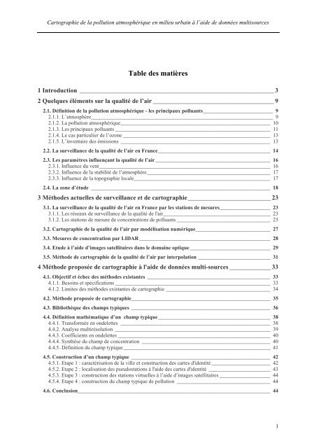
Table <strong>de</strong>s matières<br />
1 Introduction _____________________________________________________________ 3<br />
2 Quelques élém<strong>en</strong>ts sur <strong>la</strong> qualité <strong>de</strong> l’air ______________________________________ 9<br />
2.1. Définition <strong>de</strong> <strong>la</strong> <strong>pollution</strong> <strong>atmosphérique</strong> - les principaux polluants__________________________ 9<br />
2.1.1. L’atmosphère____________________________________________________________________ 9<br />
2.1.2. La <strong>pollution</strong> <strong>atmosphérique</strong>________________________________________________________ 10<br />
2.1.3. Les principaux polluants __________________________________________________________ 11<br />
2.1.4. Le cas particulier <strong>de</strong> l’ozone _______________________________________________________ 13<br />
2.1.5. L’inv<strong>en</strong>taire <strong>de</strong>s émissions ________________________________________________________ 13<br />
2.2. La surveil<strong>la</strong>nce <strong>de</strong> <strong>la</strong> qualité <strong>de</strong> l’air <strong>en</strong> France__________________________________________ 14<br />
2.3. Les paramètres influ<strong>en</strong>çant <strong>la</strong> qualité <strong>de</strong> l’air___________________________________________ 16<br />
2.3.1. Influ<strong>en</strong>ce du v<strong>en</strong>t________________________________________________________________ 16<br />
2.3.2. Influ<strong>en</strong>ce <strong>de</strong> <strong>la</strong> stabilité <strong>de</strong> l’atmosphère______________________________________________ 17<br />
2.3.3. Influ<strong>en</strong>ce <strong>de</strong> <strong>la</strong> topographie locale___________________________________________________ 17<br />
2.4. La zone d’étu<strong>de</strong> ___________________________________________________________________ 18<br />
3 Métho<strong>de</strong>s actuelles <strong>de</strong> surveil<strong>la</strong>nce et <strong>de</strong> <strong>cartographie</strong> __________________________ 23<br />
3.1. La surveil<strong>la</strong>nce <strong>de</strong> <strong>la</strong> qualité <strong>de</strong> l’air <strong>en</strong> France par les stations <strong>de</strong> mesures___________________ 23<br />
3.1.1. Les réseaux <strong>de</strong> surveil<strong>la</strong>nce <strong>de</strong> <strong>la</strong> qualité <strong>de</strong> l'air________________________________________ 23<br />
3.1.2. Les stations <strong>de</strong> mesure <strong>de</strong> conc<strong>en</strong>trations <strong>de</strong> polluants ___________________________________ 23<br />
3.2. Cartographie <strong>de</strong> <strong>la</strong> qualité <strong>de</strong> l’air par modélisation numérique____________________________ 27<br />
3.3. Mesures <strong>de</strong> conc<strong>en</strong>tration par LIDAR _________________________________________________ 28<br />
3.4. Etu<strong>de</strong> <strong>à</strong> l’ai<strong>de</strong> d’images satellitaires dans le domaine optique ______________________________ 29<br />
3.5. Métho<strong>de</strong> <strong>de</strong> <strong>cartographie</strong> <strong>de</strong> <strong>la</strong> qualité <strong>de</strong> l’air par interpo<strong>la</strong>tion ___________________________ 31<br />
4 Métho<strong>de</strong> proposée <strong>de</strong> <strong>cartographie</strong> <strong>à</strong> l'ai<strong>de</strong> <strong>de</strong> données multi-sources _____________ 33<br />
4.1. Objectif et échec <strong>de</strong>s métho<strong>de</strong>s existantes ______________________________________________ 33<br />
4.1.1. Besoins et spécifications __________________________________________________________ 33<br />
4.1.2. Limites <strong>de</strong>s métho<strong>de</strong>s existantes <strong>de</strong> <strong>cartographie</strong> _______________________________________ 34<br />
4.2. Métho<strong>de</strong> proposée <strong>de</strong> <strong>cartographie</strong>____________________________________________________ 35<br />
4.3. Bibliothèque <strong>de</strong>s champs typiques ____________________________________________________ 36<br />
4.4. Définition mathématique d’un champ typique__________________________________________ 38<br />
4.4.1. Transformée <strong>en</strong> on<strong>de</strong>lettes ________________________________________________________ 38<br />
4.4.2. Analyse multirésolution __________________________________________________________ 39<br />
4.4.3. Coeffici<strong>en</strong>ts <strong>en</strong> on<strong>de</strong>lettes _________________________________________________________ 40<br />
4.4.4. Synthèse du champ <strong>de</strong> conc<strong>en</strong>tration ________________________________________________ 40<br />
4.4.5. Définition du champ typique_______________________________________________________ 41<br />
4.5. Construction d’un champ typique ____________________________________________________ 42<br />
4.5.1. Etape 1 : caractérisation <strong>de</strong> <strong>la</strong> ville et construction <strong>de</strong>s cartes d'i<strong>de</strong>ntité ______________________ 42<br />
4.5.2. Etape 2 : localisation <strong>de</strong>s pseudostations <strong>à</strong> l'ai<strong>de</strong> <strong>de</strong>s cartes d'i<strong>de</strong>ntité _______________________ 43<br />
4.5.3. Etape 3 : construction <strong>de</strong>s stations virtuelles <strong>à</strong> l’ai<strong>de</strong> d’images satellitaires ___________________ 44<br />
4.5.4. Etape 4 : construction du champ typique <strong>de</strong> <strong>pollution</strong> ___________________________________ 44<br />
4.6. Conclusion________________________________________________________________________ 44<br />
1


