download pdf - Institut für Umweltphysik - Ruprecht-Karls-Universität ...
download pdf - Institut für Umweltphysik - Ruprecht-Karls-Universität ...
download pdf - Institut für Umweltphysik - Ruprecht-Karls-Universität ...

Create successful ePaper yourself
Turn your PDF publications into a flip-book with our unique Google optimized e-Paper software.
56 CHAPTER 2. ATMOSPHERE AND REMOTE SENSING<br />
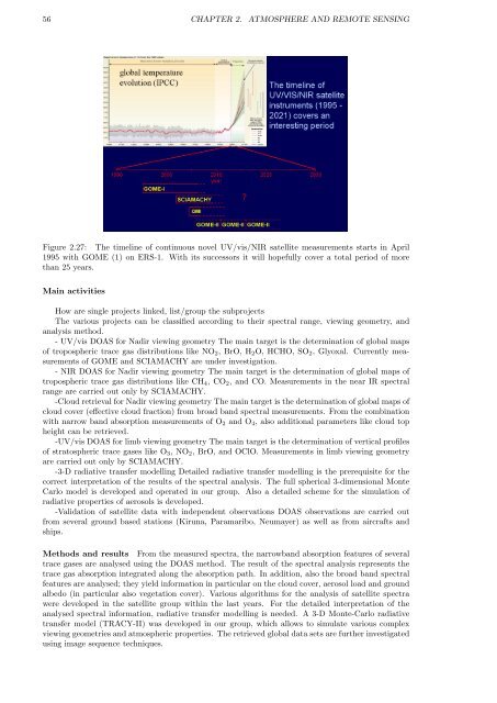
Figure 2.27: The timeline of continuous novel UV/vis/NIR satellite measurements starts in April<br />
1995 with GOME (1) on ERS-1. With its successors it will hopefully cover a total period of more<br />
than 25 years.<br />
Main activities<br />
How are single projects linked, list/group the subprojects<br />
The various projects can be classified according to their spectral range, viewing geometry, and<br />
analysis method.<br />
- UV/vis DOAS for Nadir viewing geometry The main target is the determination of global maps<br />
of tropospheric trace gas distributions like NO2, BrO, H2O, HCHO, SO2, Glyoxal. Currently measurements<br />
of GOME and SCIAMACHY are under investigation.<br />
- NIR DOAS for Nadir viewing geometry The main target is the determination of global maps of<br />
tropospheric trace gas distributions like CH4, CO2, and CO. Measurements in the near IR spectral<br />
range are carried out only by SCIAMACHY.<br />
-Cloud retrieval for Nadir viewing geometry The main target is the determination of global maps of<br />
cloud cover (effective cloud fraction) from broad band spectral measurements. From the combination<br />
with narrow band absorption measurements of O2 and O4, also additional parameters like cloud top<br />
height can be retrieved.<br />
-UV/vis DOAS for limb viewing geometry The main target is the determination of vertical profiles<br />
of stratospheric trace gases like O3, NO2, BrO, and OClO. Measurements in limb viewing geometry<br />
are carried out only by SCIAMACHY.<br />
-3-D radiative transfer modelling Detailed radiative transfer modelling is the prerequisite for the<br />
correct interpretation of the results of the spectral analysis. The full spherical 3-dimensional Monte<br />
Carlo model is developed and operated in our group. Also a detailed scheme for the simulation of<br />
radiative properties of aerosols is developed.<br />
-Validation of satellite data with independent observations DOAS observations are carried out<br />
from several ground based stations (Kiruna, Paramaribo, Neumayer) as well as from aircrafts and<br />
ships.<br />
Methods and results From the measured spectra, the narrowband absorption features of several<br />
trace gases are analysed using the DOAS method. The result of the spectral analysis represents the<br />
trace gas absorption integrated along the absorption path. In addition, also the broad band spectral<br />
features are analysed; they yield information in particular on the cloud cover, aerosol load and ground<br />
albedo (in particular also vegetation cover). Various algorithms for the analysis of satellite spectra<br />
were developed in the satellite group within the last years. For the detailed interpretation of the<br />
analysed spectral information, radiative transfer modelling is needed. A 3-D Monte-Carlo radiative<br />
transfer model (TRACY-II) was developed in our group, which allows to simulate various complex<br />
viewing geometries and atmospheric properties. The retrieved global data sets are further investigated<br />
using image sequence techniques.