- Page 3 and 4:
Proceedings of the VII Internationa
- Page 5:
SCIENTIFIC COMMITTEE Olivier Arino
- Page 8 and 9:
Analysis of human-caused wildfire o
- Page 10 and 11: Monitoring post-fire vegetation reg
- Page 12 and 13: 10 Agency, Italian National Forestr
- Page 15: I PRE-FIRE PLANNING AND MANAGEMENT
- Page 18 and 19: 16 I - PRE-FIRE PLANNING AND MANAGE
- Page 20 and 21: 18 I - PRE-FIRE PLANNING AND MANAGE
- Page 23 and 24: USING SPATIAL ANALYSIS TO CHARACTER
- Page 25 and 26: Using spatial analysis to character
- Page 27 and 28: Abstract: Fire is the major stand-r
- Page 29 and 30: Fire and climate change in Boreal F
- Page 31 and 32: Fire and climate change in Boreal F
- Page 33 and 34: Fire and climate change in Boreal F
- Page 35 and 36: PROJECTING FUTURE BURNT AREA IN THE
- Page 37 and 38: Projecting future burnt area in the
- Page 39 and 40: Projecting future burnt area in the
- Page 41 and 42: MULTISCALE CHARACTERIZATION OF SPAT
- Page 43 and 44: Multiscale characterization of spat
- Page 45: Multiscale characterization of spat
- Page 48 and 49: 46 I - PRE-FIRE PLANNING AND MANAGE
- Page 50 and 51: 48 I - PRE-FIRE PLANNING AND MANAGE
- Page 52 and 53: 50 I - PRE-FIRE PLANNING AND MANAGE
- Page 54 and 55: 52 I - PRE-FIRE PLANNING AND MANAGE
- Page 56 and 57: 54 I - PRE-FIRE PLANNING AND MANAGE
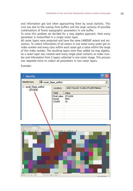
- Page 59: CLASSIFICATION OF SITE AND STAND CH
- Page 63 and 64: Classification of site and stand ch
- Page 65 and 66: FUEL MOISTURE CONTENT ESTIMATION: A
- Page 67 and 68: Fuel moisture content estimation: a
- Page 69: Fuel moisture content estimation: a
- Page 72 and 73: 70 I - PRE-FIRE PLANNING AND MANAGE
- Page 74 and 75: 72 I - PRE-FIRE PLANNING AND MANAGE
- Page 77 and 78: FUEL MODEL MAPPING USING IKONOS IMA
- Page 79 and 80: Fuel model mapping using ikonos ima
- Page 81 and 82: FIRST STEPS TOWARDS A LONG TERM FOR
- Page 83 and 84: First steps towards a long term for
- Page 85: 3 - Conclusion and further research
- Page 88 and 89: 86 I - PRE-FIRE PLANNING AND MANAGE
- Page 90 and 91: 88 I - PRE-FIRE PLANNING AND MANAGE
- Page 93 and 94: FUEL MOISTURE CONTENT ESTIMATION BA
- Page 95 and 96: 3 - Results Fuel moisture content e
- Page 97 and 98: CYBERPARK PROJECT: MULTITEMPORAL SA
- Page 99 and 100: Cyberpark project: Multitemporal sa
- Page 101 and 102: REMOTE SENSING-BASED MAPPING OF FUE
- Page 103 and 104: Remote Sensing-based Mapping of fue
- Page 105 and 106: ASSESSING CRITICAL FUEL PARAMETERS
- Page 107 and 108: Assessing critical fuel parameters
- Page 109: II VALIDATION OF RS PRODUCTS FOR FI
- Page 112 and 113:
110 II - VALIDATION OF RS PRODUCTS
- Page 114 and 115:
112 II - VALIDATION OF RS PRODUCTS
- Page 117 and 118:
RELATIONSHIPS BETWEEN COMBUSTION PR
- Page 119 and 120:
Relationships between combustion pr
- Page 121:
Relationships between combustion pr
- Page 124 and 125:
122 II - VALIDATION OF RS PRODUCTS
- Page 126 and 127:
124 II - VALIDATION OF RS PRODUCTS
- Page 129 and 130:
OPERATIONAL USE OF REMOTE SENSING I
- Page 131 and 132:
Operational use of remote sensing i
- Page 133:
Operational use of remote sensing i
- Page 136 and 137:
134 II - VALIDATION OF RS PRODUCTS
- Page 138 and 139:
136 II - VALIDATION OF RS PRODUCTS
- Page 141 and 142:
GLOBAL MONITORING OF THE ENVIRONMEN
- Page 143 and 144:
Global monitoring of the environmen
- Page 145:
Global monitoring of the environmen
- Page 148 and 149:
146 II - VALIDATION OF RS PRODUCTS
- Page 150 and 151:
148 II - VALIDATION OF RS PRODUCTS
- Page 153 and 154:
DAILY MONITORING OF PRE-FIRE VEGETA
- Page 155 and 156:
Daily monitoring of pre-fire vegeta
- Page 157 and 158:
THE GLOBAL MODIS BURNED AREA PRODUC
- Page 159 and 160:
The global MODIS burned area produc
- Page 161:
III FIRE DETECTION AND FIRE MONITOR
- Page 164 and 165:
162 III - FIRE DETECTION AND FIRE M
- Page 166 and 167:
164 III - FIRE DETECTION AND FIRE M
- Page 169 and 170:
REAL-TIME MONITORING OF THE TRANSMI
- Page 171 and 172:
Real-time monitoring of the transmi
- Page 173 and 174:
NOAA’S OPERATIONAL FIRE AND SMOKE
- Page 175 and 176:
Noaa’s operational fire and smoke
- Page 177 and 178:
SYSTEM FOR EARLY FOREST FIRE DETECT
- Page 179 and 180:
3 - Result in Germany System for ea
- Page 181:
References System for early forest
- Page 184 and 185:
182 III - FIRE DETECTION AND FIRE M
- Page 186 and 187:
184 III - FIRE DETECTION AND FIRE M
- Page 189 and 190:
ADVANCING THE USE OF MULTI-RESOLUTI
- Page 191 and 192:
Advancing the use of multi-resoluti
- Page 193:
Advancing the use of multi-resoluti
- Page 196 and 197:
194 III - FIRE DETECTION AND FIRE M
- Page 198 and 199:
196 III - FIRE DETECTION AND FIRE M
- Page 200 and 201:
198 III - FIRE DETECTION AND FIRE M
- Page 203:
IV BURNED LAND MAPPING, FIRE SEVERI
- Page 206 and 207:
204 IV - BURNED LAND MAPPING, FIRE
- Page 208 and 209:
206 IV - BURNED LAND MAPPING, FIRE
- Page 211 and 212:
Abstract: The aim of this paper is
- Page 213 and 214:
Burnt area index using MODIA and AS
- Page 215 and 216:
4 - Conclusions Burnt area index us
- Page 217 and 218:
SATELLITE DERIVED MULTI-YEAR BURNED
- Page 219 and 220:
Satellite derived multi-year burned
- Page 221:
Satellite derived multi-year burned
- Page 224 and 225:
222 IV - BURNED LAND MAPPING, FIRE
- Page 226 and 227:
224 IV - BURNED LAND MAPPING, FIRE
- Page 229 and 230:
MODIS REFLECTIVE AND ACTIVE FIRE DA
- Page 231 and 232:
3 - Methodology and results MODIS r
- Page 233:
MODIS reflective and active fire da
- Page 236 and 237:
234 IV - BURNED LAND MAPPING, FIRE
- Page 238 and 239:
236 IV - BURNED LAND MAPPING, FIRE
- Page 240 and 241:
238 IV - BURNED LAND MAPPING, FIRE
- Page 242 and 243:
240 IV - BURNED LAND MAPPING, FIRE
- Page 245 and 246:
SOME NOTES ON SPECTRAL PROPERTIES O
- Page 247 and 248:
Some notes on spectral properties o
- Page 249 and 250:
MONITORING POST-FIRE VEGETATION REG
- Page 251 and 252:
Monitoring post-fire vegetation reg
- Page 253:
Monitoring post-fire vegetation reg
- Page 256 and 257:
254 IV - BURNED LAND MAPPING, FIRE
- Page 258 and 259:
256 IV - BURNED LAND MAPPING, FIRE
- Page 261 and 262:
Abstract: SAR data from a test site
- Page 263 and 264:
Backscatter properties of x- and c-
- Page 265:
6 - Conclusions Backscatter propert
- Page 268 and 269:
266 IV - BURNED LAND MAPPING, FIRE
- Page 270 and 271:
268 IV - BURNED LAND MAPPING, FIRE
- Page 273 and 274:
CORRECTION OF TOPOGRAPHIC EFFECTS I
- Page 275 and 276:
Correction of topographic effects i
- Page 277 and 278:
Correction of topographic effects i
- Page 279 and 280:
BURNED AREAS MAPPING BY MULTISPECTR
- Page 281 and 282:
Burned areas mapping by multispectr
- Page 283 and 284:
Burned areas mapping by multispectr
- Page 285 and 286:
4 - Conclusions Burned areas mappin
- Page 287 and 288:
Abstract: In this paper NDVI VEGETA
- Page 289 and 290:
Post Fire vegetation recovery estim
- Page 291:
Post Fire vegetation recovery estim
- Page 294 and 295:
292 FORTUNATO G. pag. 191 FRENCH N.
- Page 296:
Finito di stampare nel mese di agos