Revised Deposit Plan - Wychavon District Council
Revised Deposit Plan - Wychavon District Council
Revised Deposit Plan - Wychavon District Council

Create successful ePaper yourself
Turn your PDF publications into a flip-book with our unique Google optimized e-Paper software.
1.3. How to use the <strong>Plan</strong><br />
1.3.1. The Local <strong>Plan</strong> consists of a Written Statement and Proposals Map. The<br />
Proposals Map identifies sites allocated for development and designated<br />
areas subject to specific Policies contained in the Written Statement.<br />
1.3.2. There are a number of key changes in the <strong>Revised</strong> <strong>Deposit</strong> <strong>Plan</strong> from the<br />
existing adopted <strong>Plan</strong> which should be noted:<br />
• increased emphasis on integrating sustainable development, transport and<br />
land-use Policies with the aim of minimising the need to travel advocated<br />
by <strong>Plan</strong>ning Policy Guidance Note 12 – Development <strong>Plan</strong>s;<br />
• increased emphasis on the reuse of previously developed land and making<br />
best use of existing resources advocated in <strong>Plan</strong>ning Policy Guidance<br />
Note 3 – Housing;<br />
• increased emphasis on design led approaches to planning;<br />
• a shift away from “topic” based sections, for example, housing and<br />
employment towards a structure reflecting sustainability objectives; and<br />
• a shift away from site specific Policies to criteria based Polices.<br />
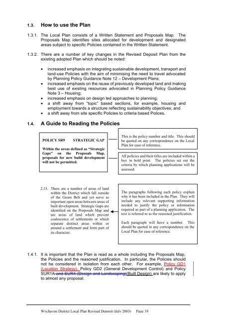
1.4. A Guide to Reading the Policies<br />
POLICY SR9 STRATEGIC GAP<br />
Within the areas defined as “Strategic<br />
Gaps” on the Proposals Map,<br />
proposals for new build development<br />
will not be permitted.<br />
2.15. There are a number of areas of land<br />
within the <strong>District</strong> which fall outside<br />
of the Green Belt and yet serve as<br />
important open areas between areas of<br />
built development. Strategic Gaps are<br />
identified on the Proposals Map and<br />
are areas of land which prevent<br />
coalescence of settlements or which<br />
separate distinct areas within or<br />
around a settlement and form part of<br />
its character.<br />
1.4.1. It is important that the <strong>Plan</strong> is read as a whole including the Proposals Map,<br />
the Policies and the reasoned justification. In particular, the Policies should<br />
not be considered in isolation from each other. For example, Policy GD1<br />
(Location Strategy), Policy GD2 (General Development Control) and Policy<br />
SUR1A and SUR4 (Design and Landscaping)(Built Design) are likely to apply<br />
to almost any proposal.<br />
<strong>Wychavon</strong> <strong>District</strong> Local <strong>Plan</strong> <strong>Revised</strong> <strong>Deposit</strong> (July 2003) Page 19<br />
This is the policy number and title. This should<br />
be quoted on any correspondence on the Local<br />
<strong>Plan</strong> for ease of reference.<br />
All policies and their titles are included within a<br />
box in bold print. The policies set out the<br />
criteria by which planning applications will be<br />
assessed.<br />
The paragraphs following each policy explain<br />
why it has been included in the <strong>Plan</strong>. They will<br />
include any relevant supporting information<br />
needed to justify the policy or information<br />
required as part of a planning application. The<br />
text is referred to as the reasoned justification.<br />
Each paragraph will have a number. This<br />
should be quoted in any correspondence on the<br />
Local <strong>Plan</strong> for ease of reference.