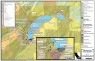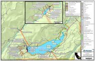
Martis Valley Groundwater Management Plan - Placer County Water ...
Martis Valley Groundwater Management Plan - Placer County Water ...
Martis Valley Groundwater Management Plan - Placer County Water ...

Create successful ePaper yourself
Turn your PDF publications into a flip-book with our unique Google optimized e-Paper software.
Depth-to-groundwater Procedures and Frequency of Monitoring and Reporting<br />
The depth-to-static-groundwater level will be obtained at each well using an electric water-level<br />
sounder with a cable graduated in increments of 0.01 foot. Before measurement, monitoring<br />
staff will need to review the WMLB for the location of the reference point and measurement<br />
access port. A crescent wrench may be needed to access the well casing for measurement.<br />
Monitoring staff will need to also review past measurements in the WMLB to allow for careful<br />
lowering of the probe or tape. 3 To obtain a depth-to-water measurement, the electric sounder<br />
cable or tape will be lowered into the well to within 20 feet short of past measurements taken in<br />
the same season of the year, spring or fall.<br />
Monitoring staff will continue to slowly lower the probe through the access port until the<br />
sounder indicates submergence by either a beeping sound or a light, depending on the type of<br />
signal installed for that particular model. At this point, the sampling personnel will note the<br />
depth to water (to the nearest 0.01 foot) from the reference point. The depth will be confirmed<br />
by lifting the sounder above the water surface by about 2 to 3 feet and then remeasuring the<br />
depth to water. If the depth remains constant, the depth to water will be recorded on Figure 6-1<br />
(DWR Form 1213, Page 18). If measurements are showing change with each measurement, the<br />
monitoring staff will indicate the issue on the form and, with it, attach a graphic curve of the<br />
variable nature of the measurement, and its possible cause (e.g., bouncing, recovering water<br />
level).<br />
5.3 QUALITY CONTROL<br />
After completing their field work, the monitoring staff will enter the data into an electronic<br />
database management system. The monitoring staff will review the groundwater-level and water<br />
quality data for accuracy within 5 days of obtaining the measurements. Should a measurement<br />
appear suspicious, a groundwater level confirmation reading will be obtained.<br />
3<br />
Tape measurements will require chalking of the tape and repeated measurements as per the CASGEM Guidelines<br />
(Page 15).<br />
5-3