Martis Valley Groundwater Management Plan - Placer County Water ...
Martis Valley Groundwater Management Plan - Placer County Water ...
Martis Valley Groundwater Management Plan - Placer County Water ...

Create successful ePaper yourself
Turn your PDF publications into a flip-book with our unique Google optimized e-Paper software.
<strong>Martis</strong> <strong>Valley</strong> <strong>Groundwater</strong> <strong>Management</strong> <strong>Plan</strong> Section 1<br />
Category<br />
Recommended<br />
Table 1-4. Recommended Components and Associated Report Section<br />
GMP Components<br />
Recommended Components<br />
(From Bulletin 118-2003 Appendix C)<br />
4 Establish management objectives (MOs) for the groundwater basin<br />
subject to the GMP<br />
DRAFT for review purposes only. Use of contents on this sheet is subject to the limitations specified at the end of this document.<br />
P:\40000\140691 - PCWA <strong>Martis</strong> <strong>Valley</strong> GWP\GMP\Report\3rd Draft\<strong>Martis</strong> <strong>Valley</strong> GMP Draft 01-09-13.docx<br />
Report<br />
Section<br />
Section 1.5<br />
5 Describe the GMP’s monitoring program Section 3.4<br />
6 Describe efforts to coordinate with land use, zoning, or water<br />
management planning agencies or activities<br />
7 Create a summary of monitoring locations with frequency of wells<br />
monitored<br />
8 Provide periodic reports summarizing groundwater conditions and<br />
management activities including:<br />
• A summary of monitoring results, with a discussion of historical<br />
trends<br />
• A summary of management actions during the period covered by<br />
the report<br />
• A discussion of whether actions are achieving progress towards<br />
meeting BMOs<br />
• A summary of proposed management actions for the future<br />
• A summary of any GMP changes that occurred during the period<br />
covered by the report<br />
• A summary of actions taken to coordinate with other water and<br />
land agencies and other government agencies<br />
9 Provide for the periodic re-evaluation of the entire plan by the<br />
managing entity<br />
1.7 Area Covered by the GMP<br />
Section 3.4<br />
Appendix D<br />
Section 3.1<br />
Section 3.1<br />
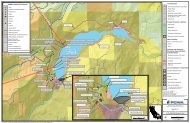
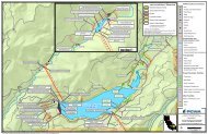
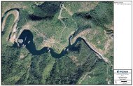
The <strong>Martis</strong> <strong>Valley</strong> GMP includes the service areas of the TDPUD, PCWA, and NCSD that overlay and<br />
extend beyond the MVGB boundary, as well as the <strong>Placer</strong> <strong>County</strong> portion of the MVGB. It is important to<br />
note that at the time of GMP development, there were no other agencies within the <strong>Placer</strong> <strong>County</strong> portion<br />
of the MVGB that fall within the service area of another local agency, water corporation regulated by the<br />
Public Utilities Commission (PUC), or mutual water company without the agreement of the overlying<br />
agency, as defined in the CWC (CWC § 10750.7(a)). Figure 1-1 shows the <strong>Martis</strong> <strong>Valley</strong> GMP area.<br />
1.8 Public Outreach and Education<br />
The partner agencies developed a Public Outreach <strong>Plan</strong> to guide development of the GMP. Public<br />
outreach included the formation of a Stakeholder Working Group to provide input on GMP development,<br />
two informative public meetings, and publically noticed public hearings (Appendix A) on the intent to<br />
draft and adopt the GMP. The Public Outreach <strong>Plan</strong> is included in Appendix C.<br />
1.9 <strong>Groundwater</strong> Model<br />
The partner agencies are currently collaborating with the Bureau of Reclamation (Reclamation) and their<br />
subcontractor, Desert Research Institute (DRI), to develop an integrated watershed-groundwater model<br />
in conjunction with the <strong>Martis</strong> <strong>Valley</strong> GMP. The geologic investigation conducted and documented in<br />
Section 2 of this report has been used to develop a geologic framework database, which was used to<br />
1-8