- Page 1 and 2:
Martis Valley Groundwater Managemen
- Page 3 and 4:
This Groundwater Management Plan (G
- Page 5 and 6:
Martis Valley Groundwater Managemen
- Page 7 and 8:
Martis Valley Groundwater Managemen
- Page 9 and 10:
Martis Valley Groundwater Managemen
- Page 11 and 12:
P:\40000\140691 - PCWA Martis Valle
- Page 13 and 14:
Martis Valley Groundwater Managemen
- Page 15 and 16:
Martis Valley Groundwater Managemen
- Page 17 and 18:
Martis Valley Groundwater Managemen
- Page 19:
Section 2 Physical Setting The MVGB
- Page 22 and 23:
Martis Valley Groundwater Managemen
- Page 24 and 25:
Martis Valley Groundwater Managemen
- Page 26 and 27:
Martis Valley Groundwater Managemen
- Page 28 and 29:
Martis Valley Groundwater Managemen
- Page 30:
Martis Valley Groundwater Managemen
- Page 38 and 39:
Martis Valley Groundwater Managemen
- Page 40 and 41:
Martis Valley Groundwater Managemen
- Page 43 and 44:
Martis Valley Groundwater Managemen
- Page 45 and 46:
Martis Valley Groundwater Managemen
- Page 47 and 48:
Independence Lake Donner Euer Valle
- Page 49 and 50:
Independence Lake Donner Euer Valle
- Page 51 and 52:
Martis Valley Groundwater Managemen
- Page 53 and 54:
Martis Valley Groundwater Managemen
- Page 55 and 56:
Martis Valley Groundwater Managemen
- Page 57 and 58:
Legend Q Martis Valley Groundwater
- Page 59 and 60:
Martis Valley Groundwater Managemen
- Page 61 and 62:
Martis Valley Groundwater Managemen
- Page 63 and 64:
Martis Valley Groundwater Managemen
- Page 65 and 66:
Martis Valley Groundwater Managemen
- Page 67 and 68:
RESOLUTION NO. 11 - .!30F THE BOARD
- Page 70:
NOW, THEREFORE, the BOARD OF DIRECT
- Page 78 and 79:
16395813 PUBLIC NOTICE ·----------
- Page 80 and 81: Page 2 of 2 of the Agenda of the Ma
- Page 82 and 83: Martis Valley Groundwater Managemen
- Page 84 and 85: Introduction Martis Valley GMP - Dr
- Page 86 and 87: Martis Valley GMP - Draft Public Ou
- Page 88 and 89: Martis Valley Groundwater Managemen
- Page 90 and 91: TABLE OF CONTENTS i Table of Conten
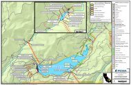
- Page 92 and 93: FIGURE 1-1. MAP OF GROUNDWATER BASI
- Page 94 and 95: 2.0 BACKGROUND 2-1 Background This
- Page 96 and 97: ELEVATION (FEET NAVD88) A North 750
- Page 98 and 99: ELEVATION (FEET NAVD88) 7500 7000 6
- Page 100 and 101: DWR CASGEM Well FIGURE 3-1. EXISTIN
- Page 102 and 103: Figure 3‐1 Reference Index 1 2 3
- Page 104 and 105: 3.4 REQUIRED STEPS IN SELECTING A N
- Page 106 and 107: 4.0 MONITORING EQUIPMENT AND PREPAR
- Page 108 and 109: 4-3 Monitoring Equipment and Prepar
- Page 110 and 111: Keys for gates and monitoring well
- Page 112 and 113: 4-7 Monitoring Equipment and Prepar
- Page 114 and 115: Depth-to-groundwater Procedures and
- Page 116 and 117: Recording of Monitoring Data, Data
- Page 118 and 119: Recording of Monitoring Data, Data
- Page 120 and 121: Department of Water Resources Groun
- Page 122 and 123: INTRODUCTION TO THE CASGEM PROGRAM
- Page 124 and 125: exceptions to this density range in
- Page 126 and 127: FREQUENCY OF WATER‐LEVEL MEASUREM
- Page 128 and 129: Figure 3. Common environmental fact
- Page 132 and 133: Table 3. General well data form (DW
- Page 134 and 135: Table 4. Equipment and Supply List
- Page 136 and 137: conditions may require deviating fr
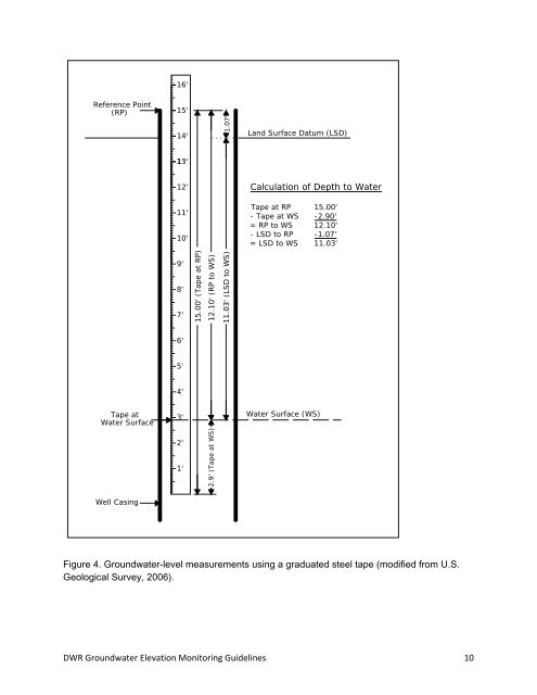
- Page 138 and 139: 6. Subtract the “Tape at WS” nu
- Page 140 and 141: (2) Electric Sounding Tape Method T
- Page 142 and 143: ecording this measurement with the
- Page 144 and 145: idea of the expected range of groun
- Page 146 and 147: Top of Casing (RP) Hanging Point Ba
- Page 148 and 149: Table 6. Groundwater level data for
- Page 150 and 151: GLOSSARY OF TERMS The following ter
- Page 152 and 153: Groundwater subbasin - A subdivisio
- Page 154 and 155: REFERENCES Alley, W.M., ed., 1993,
- Page 156 and 157: Appendix B CASGEM Monitoring Plan S
- Page 158 and 159: • groundwater conditions in the b
- Page 160 and 161: Monitoring Entities will submit the
- Page 162 and 163: IN THIS ISSUE: WATER QUALITY REPORT
- Page 164 and 165: Monitoring of Unregulated Substance
- Page 166 and 167: Primary Business Address Your Addre
- Page 168 and 169: Drinking water, including bottled w
- Page 170 and 171: U.S. Geological Survey and the Cali
- Page 172 and 173: RESULTS: Groundwater Quality in the
- Page 174 and 175: Martis Valley Groundwater Managemen
- Page 176 and 177: utilized a water balance method to
- Page 178 and 179: with water supply wells. Perennial
- Page 180 and 181:
Figure 3. PRMS model domain with a
- Page 182 and 183:
Figure 6. Value of recharge efficie
- Page 184 and 185:
Figure 8. Mean annual recharge (inc