Martis Valley Groundwater Management Plan - Placer County Water ...
Martis Valley Groundwater Management Plan - Placer County Water ...
Martis Valley Groundwater Management Plan - Placer County Water ...

You also want an ePaper? Increase the reach of your titles
YUMPU automatically turns print PDFs into web optimized ePapers that Google loves.
Recording of Monitoring Data, Data <strong>Management</strong> and the CASGEM Requirements<br />
Submit groundwater elevation measurement<br />
data<br />
View and update their CASGEM data, as<br />
needed<br />
With Phase 3 of the CASGEM System, public access to the<br />
Statewide CASGEM data will be available. Users will be able to<br />
download data and view spatial and temporal groundwater<br />
elevation trends in the GIS viewer application.<br />
(URL: http://www.water.ca.gov/groundwater/casgem/submittal_system.cfm, On-line Submittal System, DWR)<br />
The Agency has already completed Phase 1 of the CASGEM Program. The next step requires<br />
entry of data for each of the monitoring wells included as part of this Monitoring Program.<br />
Figure 6-1 is taken from the CASGEM On-line System manual. The manual states that “Data<br />
may be entered on a well‐by‐well basis on a system data entry screen, or users can do a batch<br />
upload of information from multiple wells (using a spreadsheet template available for download<br />
within the system).” The latter will likely be the best method for entering the data given that<br />
most of the well information is already captured in an Excel Workbook.<br />
Data entry for groundwater elevations is not fully described but will likely be similar to the well<br />
inventory where a spreadsheet template can be uploaded for all groundwater-elevation data. The<br />
conversion of groundwater-elevation data from a database (including GIS) platform is typically<br />
straight forward with a copy-and-paste step or a small routine that outputs the data in the desired<br />
format.<br />
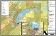
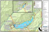
The inventory of <strong>Martis</strong> <strong>Valley</strong> well data will be based on DWR’s CASGEM Monitoring <strong>Plan</strong><br />
Summary attached as Appendix B. The set of data fields used for each well will require a<br />
decision on its need based on Appendix B requirements.<br />
6-2