Martis Valley Groundwater Management Plan - Placer County Water ...
Martis Valley Groundwater Management Plan - Placer County Water ...
Martis Valley Groundwater Management Plan - Placer County Water ...

Create successful ePaper yourself
Turn your PDF publications into a flip-book with our unique Google optimized e-Paper software.
<strong>Martis</strong> <strong>Valley</strong> <strong>Groundwater</strong> <strong>Management</strong> <strong>Plan</strong> Section 2<br />
NCSD<br />
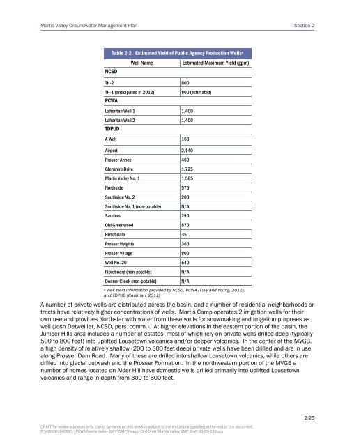
Table 2-2. Estimated Yield of Public Agency Production Wells a<br />
Well Name Estimated Maximum Yield (gpm)<br />
TH-2 800<br />
TH-1 (anticipated in 2012) 800 (estimated)<br />
PCWA<br />
Lahontan Well 1 1,400<br />
Lahontan Well 2 1,400<br />
TDPUD<br />
A Well 160<br />
Airport 2,140<br />
Prosser Annex 460<br />
Glenshire Drive 1,725<br />
<strong>Martis</strong> <strong>Valley</strong> No. 1 1,585<br />
Northside 575<br />
Southside No. 2 200<br />
Southside No. 1 (non-potable) N/A<br />
Sanders 290<br />
Old Greenwood 870<br />
Hirschdale 35<br />
Prosser Heights 360<br />
Prosser Village 800<br />
Well No. 20 540<br />
Fibreboard (non-potable) N/A<br />
Donner Creek (non-potable) N/A<br />
a Well Yield information provided by NCSD, PCWA (Tully and Young, 2011),<br />
and TDPUD (Kaufman, 2011)<br />
A number of private wells are distributed across the basin, and a number of residential neighborhoods or<br />
tracts have relatively higher concentrations of wells. <strong>Martis</strong> Camp operates 2 irrigation wells for their<br />
own use and provides Northstar with water from these wells for snowmaking and irrigation purposes as<br />
well (Josh Detweiller, NCSD, pers. comm.). At higher elevations in the eastern portion of the basin, the<br />
Juniper Hills area includes a number of estates, most of which rely on private wells drilled deep (typically<br />
500 to 800 feet) into uplifted Lousetown volcanics and/or deeper volcanics. In the center of the MVGB,<br />
a high density of relatively shallow (200 to 300 feet deep) private wells have been drilled and are in use<br />
along Prosser Dam Road. Many of these are drilled into shallow Lousetown volcanics, while others are<br />
drilled into glacial outwash and the Prosser Formation. In the northwestern portion of the MVGB a<br />
number of homes located on Alder Hill have domestic wells drilled primarily into uplifted Lousetown<br />
volcanics and range in depth from 300 to 800 feet.<br />
DRAFT for review purposes only. Use of contents on this sheet is subject to the limitations specified at the end of this document.<br />
P:\40000\140691 - PCWA <strong>Martis</strong> <strong>Valley</strong> GWP\GMP\Report\3rd Draft\<strong>Martis</strong> <strong>Valley</strong> GMP Draft 01-09-13.docx<br />
2-25