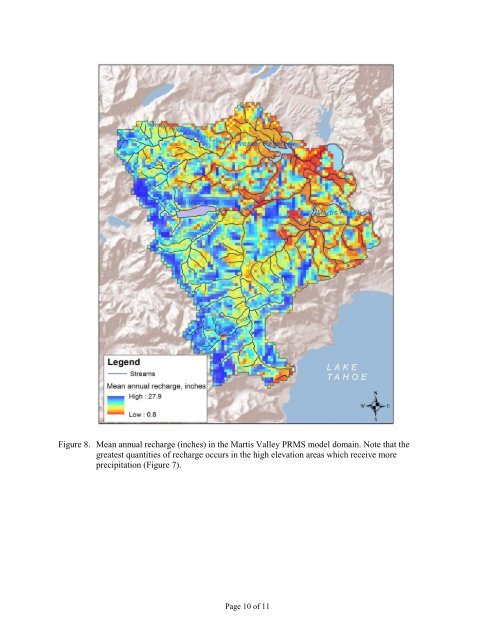
Figure 8. Mean annual recharge (inches) in the <strong>Martis</strong> <strong>Valley</strong> PRMS model domain. Note that the greatest quantities of recharge occurs in the high elevation areas which receive more precipitation (Figure 7). Page 10 of 11
References Cherkauer, D. S., and S.A. Ansari, 2005. Estimating ground water recharge from topography, hydrogeology and land cover, Ground <strong>Water</strong>, 43(1), 102-112 Cherkauer, D. S., 2004. Quantifying ground water recharge at multiple scales using PRMS and GIS, Ground <strong>Water</strong>, 42(1), 97-110. Daly, C., R. P. Neilson, and D. L. Phillips, 1994. A statistical-topographic model for mapping climatological precipitation over mountainous terrain. Journal of Applied Meteorology 33, 140- 158 Epstein, B.J., G.M. Pohll, J. Huntington, and R.W.H. Carroll, 2010. Development and uncertainty analysis of an empirical recharge prediction model for Nevada’s desert basins, Journal of the Nevada <strong>Water</strong> Resources Association 5(1). Hardman, G., 1936. Precipitation map of Nevada. Nevada Agricultural Experiment Station. Huntington, J.L. and R.G. Niswonger, 2012. Role of surface water and groundwater interactions on projected baseflows in snow dominated regions: an integrated modeling approach. <strong>Water</strong> Resources Research, in press. Hydro-Search, Inc., 1995. Ground <strong>Water</strong> <strong>Management</strong> <strong>Plan</strong> Phase 1 <strong>Martis</strong> <strong>Valley</strong> Ground-<strong>Water</strong> Basin No. 6-67 Nevada and <strong>Placer</strong> counties, California. Prepared for Truckee Donner Public Utility District January 31, 1995. Interflow Hydrology, Inc. and Cordilleran Hydrology, Inc., 2003. Measurement of Ground <strong>Water</strong> Discharge to Streams Tributary to the Truckee River in <strong>Martis</strong> <strong>Valley</strong>, <strong>Placer</strong> and Nevada Counties, California. IFH Report 2003-02, April 2003. Kennedy/Jenks Consultants, 2002. Independent Appraisal of <strong>Martis</strong> <strong>Valley</strong> Ground <strong>Water</strong> Availability Nevada and <strong>Placer</strong> Counties, California, December 2002. Leake, S.A. and J. Haney, 2010. Possible effects of groundwater pumping on surface water in the Verde <strong>Valley</strong>, Arizona, U.S. Geological Survey Fact Sheet 2010-3108. Leavesley, G.H., R.W. Lichty, B.M. Troutman, and L.G. Saindon, 1983. Precipitation-runoff modeling system—user’s manual. U.S. Geological Survey <strong>Water</strong>-Resources Investigations Report 83-4238, 207 p., accessed Aug 2012, at http://pubs.er.usgs.gov/usgspubs/wri/wri834238. Lichty, R. W. and P.W. McKinley, 1995. Estimates of ground water recharge rates for two small basins in central Nevada. U.S. Geological Survey <strong>Water</strong> Resources Investigations Report 94-4104 Maxey, G.B., and T.E. Eakin, 1949. Ground water in White River <strong>Valley</strong>, White Pine, Nye, and Lincoln counties, Nevada. State of Nevada, Office of the State Engineer, <strong>Water</strong> Resources Bulletin 8. Nimbus Engineers, 2001. Ground <strong>Water</strong> Availability in the <strong>Martis</strong> <strong>Valley</strong> Ground <strong>Water</strong> Basin. Nimbus Job No. 0043. Singleton, M.J. and J.E. Moran, 2010. Dissolved noble gas and isotopic tracers reveal vulnerability of groundwater in a small, high-elevation catchment to predicted climate changes. <strong>Water</strong> Resources Research, 46, W00F06, doi:10.1029/2009WR008718. Vaccaro, J.J. and T.D. Olsen, 2007. Estimates of ground-water recharge to the Yakima River Basin aquifer system, Washington, for predevelopment and current land-use and land-cover conditions. U.S. Geological Survey Scientific Investigations Report 2007-5007, 30 p. Page 11 of 11
- Page 1 and 2:
Martis Valley Groundwater Managemen
- Page 3 and 4:
This Groundwater Management Plan (G
- Page 5 and 6:
Martis Valley Groundwater Managemen
- Page 7 and 8:
Martis Valley Groundwater Managemen
- Page 9 and 10:
Martis Valley Groundwater Managemen
- Page 11 and 12:
P:\40000\140691 - PCWA Martis Valle
- Page 13 and 14:
Martis Valley Groundwater Managemen
- Page 15 and 16:
Martis Valley Groundwater Managemen
- Page 17 and 18:
Martis Valley Groundwater Managemen
- Page 19:
Section 2 Physical Setting The MVGB
- Page 22 and 23:
Martis Valley Groundwater Managemen
- Page 24 and 25:
Martis Valley Groundwater Managemen
- Page 26 and 27:
Martis Valley Groundwater Managemen
- Page 28 and 29:
Martis Valley Groundwater Managemen
- Page 30:
Martis Valley Groundwater Managemen
- Page 38 and 39:
Martis Valley Groundwater Managemen
- Page 40 and 41:
Martis Valley Groundwater Managemen
- Page 43 and 44:
Martis Valley Groundwater Managemen
- Page 45 and 46:
Martis Valley Groundwater Managemen
- Page 47 and 48:
Independence Lake Donner Euer Valle
- Page 49 and 50:
Independence Lake Donner Euer Valle
- Page 51 and 52:
Martis Valley Groundwater Managemen
- Page 53 and 54:
Martis Valley Groundwater Managemen
- Page 55 and 56:
Martis Valley Groundwater Managemen
- Page 57 and 58:
Legend Q Martis Valley Groundwater
- Page 59 and 60:
Martis Valley Groundwater Managemen
- Page 61 and 62:
Martis Valley Groundwater Managemen
- Page 63 and 64:
Martis Valley Groundwater Managemen
- Page 65 and 66:
Martis Valley Groundwater Managemen
- Page 67 and 68:
RESOLUTION NO. 11 - .!30F THE BOARD
- Page 70:
NOW, THEREFORE, the BOARD OF DIRECT
- Page 78 and 79:
16395813 PUBLIC NOTICE ·----------
- Page 80 and 81:
Page 2 of 2 of the Agenda of the Ma
- Page 82 and 83:
Martis Valley Groundwater Managemen
- Page 84 and 85:
Introduction Martis Valley GMP - Dr
- Page 86 and 87:
Martis Valley GMP - Draft Public Ou
- Page 88 and 89:
Martis Valley Groundwater Managemen
- Page 90 and 91:
TABLE OF CONTENTS i Table of Conten
- Page 92 and 93:
FIGURE 1-1. MAP OF GROUNDWATER BASI
- Page 94 and 95:
2.0 BACKGROUND 2-1 Background This
- Page 96 and 97:
ELEVATION (FEET NAVD88) A North 750
- Page 98 and 99:
ELEVATION (FEET NAVD88) 7500 7000 6
- Page 100 and 101:
DWR CASGEM Well FIGURE 3-1. EXISTIN
- Page 102 and 103:
Figure 3‐1 Reference Index 1 2 3
- Page 104 and 105:
3.4 REQUIRED STEPS IN SELECTING A N
- Page 106 and 107:
4.0 MONITORING EQUIPMENT AND PREPAR
- Page 108 and 109:
4-3 Monitoring Equipment and Prepar
- Page 110 and 111:
Keys for gates and monitoring well
- Page 112 and 113:
4-7 Monitoring Equipment and Prepar
- Page 114 and 115:
Depth-to-groundwater Procedures and
- Page 116 and 117:
Recording of Monitoring Data, Data
- Page 118 and 119:
Recording of Monitoring Data, Data
- Page 120 and 121:
Department of Water Resources Groun
- Page 122 and 123:
INTRODUCTION TO THE CASGEM PROGRAM
- Page 124 and 125:
exceptions to this density range in
- Page 126 and 127:
FREQUENCY OF WATER‐LEVEL MEASUREM
- Page 128 and 129:
Figure 3. Common environmental fact
- Page 130 and 131:
ESTABLISHING THE REFERENCE POINT Wa
- Page 132 and 133:
Table 3. General well data form (DW
- Page 134 and 135: Table 4. Equipment and Supply List
- Page 136 and 137: conditions may require deviating fr
- Page 138 and 139: 6. Subtract the “Tape at WS” nu
- Page 140 and 141: (2) Electric Sounding Tape Method T
- Page 142 and 143: ecording this measurement with the
- Page 144 and 145: idea of the expected range of groun
- Page 146 and 147: Top of Casing (RP) Hanging Point Ba
- Page 148 and 149: Table 6. Groundwater level data for
- Page 150 and 151: GLOSSARY OF TERMS The following ter
- Page 152 and 153: Groundwater subbasin - A subdivisio
- Page 154 and 155: REFERENCES Alley, W.M., ed., 1993,
- Page 156 and 157: Appendix B CASGEM Monitoring Plan S
- Page 158 and 159: • groundwater conditions in the b
- Page 160 and 161: Monitoring Entities will submit the
- Page 162 and 163: IN THIS ISSUE: WATER QUALITY REPORT
- Page 164 and 165: Monitoring of Unregulated Substance
- Page 166 and 167: Primary Business Address Your Addre
- Page 168 and 169: Drinking water, including bottled w
- Page 170 and 171: U.S. Geological Survey and the Cali
- Page 172 and 173: RESULTS: Groundwater Quality in the
- Page 174 and 175: Martis Valley Groundwater Managemen
- Page 176 and 177: utilized a water balance method to
- Page 178 and 179: with water supply wells. Perennial
- Page 180 and 181: Figure 3. PRMS model domain with a
- Page 182 and 183: Figure 6. Value of recharge efficie