Martis Valley Groundwater Management Plan - Placer County Water ...
Martis Valley Groundwater Management Plan - Placer County Water ...
Martis Valley Groundwater Management Plan - Placer County Water ...

Create successful ePaper yourself
Turn your PDF publications into a flip-book with our unique Google optimized e-Paper software.
<strong>Martis</strong> <strong>Valley</strong> <strong>Groundwater</strong> <strong>Management</strong> <strong>Plan</strong> Section 3<br />
3.4.2 Continue and Encourage <strong>Water</strong> Conservation Activities and Public Education<br />
The partner agencies currently implement significant water conservation and public outreach programs<br />
per State requirements. All three agencies hold public board meetings and maintain informative<br />
websites for public outreach purposes at the following web addresses:<br />
www.tdpud.org<br />
www.pcwa.net<br />
www.northstarcsd.org<br />
This implementation action encourages the partner agencies to continue to implement conservation<br />
activities and continue public outreach activities as opportunities become available.<br />
3.4.3 Work with local stakeholders and DWR to identify areas that may need additional<br />
groundwater level and groundwater quality monitoring based on identified data<br />
gaps or negative performance trends<br />
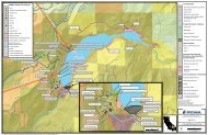
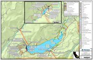
Currently, groundwater is monitored by the partner agencies under CASGEM, and by DWR, who monitors<br />
a number of wells in the MVGB. DWR monitoring wells are shown in Figure 3-1. This implementation<br />
action requires the partner agencies to work with local stakeholders and DWR to identify areas in need<br />
of additional monitoring. The SWG included two DWR North Central Region office staff and future<br />
members of the SWG should continue to include DWR staff. Through the SWG, the partner agencies will<br />
be working with local stakeholders and DWR, and will discuss identification of additional monitoring<br />
areas at the SWG annual meetings.<br />
3.4.4 Coordinate with other agencies, including DWR and the USGS to identify<br />
opportunities for land subsidence monitoring<br />
Inelastic land subsidence is caused by dewatering of aquifers and the compressing of clays. As water is<br />
removed from the aquifer, it is transported through interconnected pore spaces between grains of sand<br />
and gravel. If an aquifer has intervals of clay or silt within it, the lowered water pressure in the sand and<br />
gravel results in the slow drainage of water from the clay and silt beds. The decreased water pressure<br />
reduces the support for the clay and silt beds. Because these beds are compressible, they compact<br />
(become thinner) and the effects are seen as a lowering of the land surface. The lowering of the land<br />
surface elevation from this process is often permanent (inelastic). Recharge of the aquifer will not result<br />
in an appreciable recovery of the land-surface elevation.<br />
The partner agencies have not developed a network of extensometers to measure inelastic land<br />
subsidence. <strong>Groundwater</strong> level monitoring indicates that groundwater levels have not been significantly<br />
lowered, a condition required for land subsidence due to groundwater extraction to occur. Additionally,<br />
the geology (Section 2.4) in the MVGB does not consist of large layers of clay to be compressed, and is<br />
unlikely to experience inelastic land subsidence even if groundwater levels begin to decline. Based on a<br />
review of groundwater elevation trends over time, it can reasonably be assumed that significant land<br />
subsidence has not occurred on a regional scale due to groundwater extraction within the MVGB.<br />
Under this implementation action, the partner agencies will coordinate with DWR and the USGS to<br />
identify opportunities for collaboration to detect land subsidence. Because inelastic land subsidence is<br />
tied to groundwater levels, the primary means for early detection include:<br />
Monitor and analyze groundwater levels, watching for significant declines<br />
Inspect wells for anecdotal evidence of subsidence during groundwater level monitoring<br />
Monitoring groundwater levels with concurrent inspections for anecdotal evidence of subsidence is the<br />
least expensive, and least reliable, method to monitor for land subsidence. Declines in groundwater<br />
levels can be a precursor to land subsidence. Staff performing water level monitoring can inspect the<br />
DRAFT for review purposes only. Use of contents on this sheet is subject to the limitations specified at the end of this document.<br />
P:\40000\140691 - PCWA <strong>Martis</strong> <strong>Valley</strong> GWP\GMP\Report\3rd Draft\<strong>Martis</strong> <strong>Valley</strong> GMP Draft 01-09-13.docx<br />
3-9