Martis Valley Groundwater Management Plan - Placer County Water ...
Martis Valley Groundwater Management Plan - Placer County Water ...
Martis Valley Groundwater Management Plan - Placer County Water ...

You also want an ePaper? Increase the reach of your titles
YUMPU automatically turns print PDFs into web optimized ePapers that Google loves.
<strong>Martis</strong> <strong>Valley</strong> <strong>Groundwater</strong> <strong>Management</strong> <strong>Plan</strong> Section 2<br />
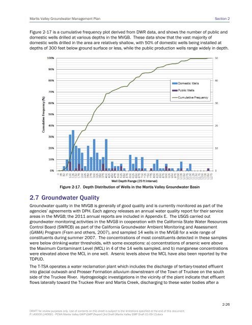
Figure 2-17 is a cumulative frequency plot derived from DWR data, and shows the number of public and<br />
domestic wells drilled at various depths in the MVGB. These data show that the vast majority of<br />
domestic wells drilled in the area are relatively shallow, with 50% of domestic wells being installed at<br />
depths of 300 feet below ground surface or less, while the public production wells range widely in depth.<br />
Figure 2-17. Depth Distribution of Wells in the <strong>Martis</strong> <strong>Valley</strong> <strong>Groundwater</strong> Basin<br />
2.7 <strong>Groundwater</strong> Quality<br />
<strong>Groundwater</strong> quality in the MVGB is generally of good quality and is currently monitored as part of the<br />
agencies’ agreements with DPH. Each agency releases an annual water quality report for their service<br />
areas in the MVGB; the 2011 annual reports are included in Appendix E. The USGS carried out<br />
groundwater monitoring activities in the MVGB in cooperation with the California State <strong>Water</strong> Resources<br />
Control Board (SWRCB) as part of the California <strong>Groundwater</strong> Ambient Monitoring and Assessment<br />
(GAMA) Program (Fram and others, 2007), and sampled 14 wells in the MVGB for a wide range of<br />
constituents during summer 2007. The concentrations of most constituents detected in these samples<br />
were below drinking-water thresholds, with some exceptions: a) concentrations of arsenic were above<br />
the Maximum Contaminant Level (MCL) in 4 of the 14 wells sampled, and b) manganese concentrations<br />
were elevated above the MCL in one well. Arsenic levels above the MCL have also been reported by the<br />
TDPUD.<br />
The T-TSA operates a water reclamation plant which includes the discharge of tertiary-treated effluent<br />
into glacial outwash and Prosser Formation alluvium downstream of the Town of Truckee on the south<br />
side of the Truckee River. Hydrogeologic investigations in the vicinity of the plant indicate that effluent<br />
flows laterally toward the Truckee River and <strong>Martis</strong> Creek, discharging to these water bodies after a<br />
DRAFT for review purposes only. Use of contents on this sheet is subject to the limitations specified at the end of this document.<br />
P:\40000\140691 - PCWA <strong>Martis</strong> <strong>Valley</strong> GWP\GMP\Report\3rd Draft\<strong>Martis</strong> <strong>Valley</strong> GMP Draft 01-09-13.docx<br />
2-26