Martis Valley Groundwater Management Plan - Placer County Water ...
Martis Valley Groundwater Management Plan - Placer County Water ...
Martis Valley Groundwater Management Plan - Placer County Water ...

You also want an ePaper? Increase the reach of your titles
YUMPU automatically turns print PDFs into web optimized ePapers that Google loves.
<strong>Martis</strong> <strong>Valley</strong> <strong>Groundwater</strong> <strong>Management</strong> <strong>Plan</strong> Section 2<br />
2.2.2 Climate Change<br />
The National Oceanic and Atmospheric Association (NOAA) and Coats and others (2010) have predicted<br />
a future shift from snowfall to rain in the next century in this region as a result of projected increases in<br />
average, minimum, and maximum air temperatures. Associated changes in surface water hydrology<br />
include potential increases in the frequency and magnitude of major flooding, such that more water may<br />
leave the basin as runoff, rather than infiltrating and recharging groundwater resources. NOAA has also<br />
predicted that climate change may result in increased drought frequency, and generally reduced water<br />
supplies (U.S. Bureau of Reclamation, 2011).<br />
The U.S. Bureau of Reclamation manages water supply in the Truckee River Basin, and is undertaking a<br />
number of studies to evaluate the degree to which water supply and demand may be impacted by future<br />
changes in climate. This includes the Truckee River Basin Study, as well as funding researchers at DRI<br />
to develop an integrated groundwater, surface water, and climate change model of the MVGB.<br />
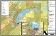
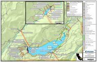
2.3 Surface <strong>Water</strong> Hydrology<br />
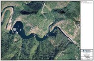
The Truckee River bisects the MVGB, with several tributaries upstream, within, and downstream of the<br />
MVGB. This section provides a brief discussion of the flow regimes of the Truckee River and the primary<br />
tributaries within the MVGB. <strong>Water</strong>shed areas are based on data available from CalAtlas, but<br />
subwatersheds shown have been modified in places for consistency with other regional studies,<br />
including the <strong>Water</strong> Quality Assessment and Modeling of the California portion of the Truckee River Basin<br />
(McGraw and others, 2001), the Truckee River <strong>Water</strong> Quality Monitoring <strong>Plan</strong> (Nichols Engineers, 2008),<br />
and the <strong>Martis</strong> <strong>Water</strong>shed Assessment (Shaw and others, 2012).<br />
2.3.1 Truckee River<br />
The Middle Truckee River1 flows out of Lake Tahoe at Tahoe City with a number of tributaries<br />
contributing streamflow upstream of <strong>Martis</strong> <strong>Valley</strong>, including Bear, Squaw, Deer, Pole, Silver, and Cabin<br />
Creeks. The Truckee River then enters the MVGB near the junction of State Highway 89 and Interstate<br />
80, flows west to east across <strong>Martis</strong> <strong>Valley</strong> before exiting the basin near Boca, just upstream of its<br />
confluence with the Little Truckee River. Main tributaries within <strong>Martis</strong> <strong>Valley</strong> are Donner, Cold2 , Trout,<br />
<strong>Martis</strong> and Prosser Creeks (Figure 2-5). Below Boca, the Truckee River descends into the Truckee<br />
Canyon before flowing through Reno and Sparks, Nevada, and terminating at Pyramid Lake.<br />
Streamflow from Lake Tahoe, Donner Lake, <strong>Martis</strong> Creek, and Prosser Creek is controlled by major dams<br />
or impoundments, with the timing of releases and streamflows guided by a number of court decrees,<br />
agreements, and regulations that govern the flow rate from California to Nevada. These streamflow<br />
rates are known as ‘Floriston Rates’ and measured at Farad, California just upstream of the State line.<br />
The Truckee River is currently operated according to the Truckee River and Reservoir Operations Model<br />
(Berris and others, 2001). The Truckee River falls under the jurisdiction of TROA, which is further<br />
discussed in Section 3.2.<br />
1 Definitions of the Upper, Middle, and Lower Truckee River vary among numerous published studies. The definition used in this<br />
report of the “Middle Truckee River” definition used in this report conforms to nomenclature used by the California Lahontan<br />
Regional <strong>Water</strong> Quality Control Board, but differs from that used by the U.S. Bureau of Reclamation.<br />
2 Though it is not a direct tributary to the Truckee River, Cold Creek flows into Donner Creek below Donner Lake, approximately<br />
1.5 miles upstream of the confluence with the Truckee River, and therefore accounts for a significant portion of the unregulated<br />
flow into the MVGB.<br />
DRAFT for review purposes only. Use of contents on this sheet is subject to the limitations specified at the end of this document.<br />
P:\40000\140691 - PCWA <strong>Martis</strong> <strong>Valley</strong> GWP\GMP\Report\3rd Draft\<strong>Martis</strong> <strong>Valley</strong> GMP Draft 01-09-13.docx<br />
2-6