Martis Valley Groundwater Management Plan - Placer County Water ...
Martis Valley Groundwater Management Plan - Placer County Water ...
Martis Valley Groundwater Management Plan - Placer County Water ...

Create successful ePaper yourself
Turn your PDF publications into a flip-book with our unique Google optimized e-Paper software.
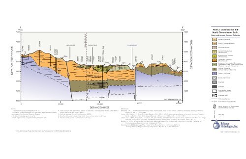
ELEVATION (FEET NAVD88)<br />
B<br />
West<br />
7500<br />
7000<br />
6500<br />
6000<br />
5500<br />
5000<br />
4500<br />
4000<br />
752945<br />
Tt<br />
?<br />
180560<br />
312956<br />
NOTES:<br />
1. Approximate vertical exaggeration = 5x.<br />
2. Elevation profile developed from 30-meter digital elevation model,<br />
downloaded from National Elevation Dataset<br />
(http://seamless.usgs.gov/index.php).<br />
3. Well log locations are approximate within 600 feet.<br />
Tv<br />
?<br />
Qv<br />
\\192.168.1.152\gis\Projects\210142 <strong>Martis</strong> GMP\CrossSection\110925ProfileB_BFinalDraft.ai<br />
290853<br />
?<br />
312985<br />
354807<br />
0 10,000 20,000<br />
Qgo<br />
?<br />
Highway 89<br />
?<br />
38890<br />
753025<br />
?<br />
323656<br />
153113<br />
186854<br />
119903<br />
4. Fault locations are approximate, based on Saucedo, “Geologic Map of Lake Tahoe Basin,”<br />
2005 and Hunter and others, 2011.<br />
5. Surficial geology inferred from Saucedo, 2005.<br />
6. Significant sand, gravel, and clay beds shown where noted in well logs.<br />
7. Fracture zones shown where noted in well logs.<br />
?<br />
290858<br />
233993<br />
Prosser Village Well<br />
DISTANCE IN FEET<br />
?<br />
?<br />
712059<br />
181525<br />
Qgo<br />
Qpc<br />
Qps<br />
Qgo<br />
Qpc<br />
Qpc<br />
Qps<br />
Qv<br />
Tt<br />
Cross-Section A-A’<br />
Polaris Fault<br />
Tv<br />
?<br />
?<br />
753383<br />
Qv<br />
Tt<br />
Tv<br />
Truckee River<br />
?<br />
Qv<br />
?<br />
233946<br />
Qgo<br />
Qv<br />
?<br />
Qjf<br />
433600<br />
?<br />
Tt<br />
Qjf<br />
Tv<br />
65421<br />
30,000 40,000<br />
Qv<br />
References:<br />
Birkeland, P.W., 1963 Pleistocene History of the Truckee area, north of Lake Tahoe, California, Geological Society of America<br />
Bulletin, v. 64, p. 1453-1464.<br />
Hunter, L.E., Howle, J.F., Rose, R.S., and Bawden, G.W., 2011, LiDAR – assisted identification of an active fault near Truckee,<br />
California, Bulletin of the Seismological Society of America, v. 101, n. 3, p. 1162-1181.<br />
Latham, T.S., 1985, Stratigraphy, structure, and geochemistry of Plio-Pleistocene volcanic rocks of the western Basin and Range<br />
Province, near Truckee, California, unpublished doctoral dissertation, University of California, Davis, 341 p.<br />
Melody, A., 2009, Active faulting and Quaternary paleohydrology of the Truckee Fault Zone north of Truckee, California, MS<br />
Thesis, Humboldt State University, Humboldt, CA 71 p.<br />
Saucedo, G.J., 2005, Geologic Map of Lake Tahoe Basin, California and Nevada, California<br />
Geological Survey Regional Geologic Map Series, Map No. 4, 1:100,000 scale.<br />
?<br />
Qls<br />
561677<br />
769296<br />
Qv<br />
?<br />
Qgo<br />
Vertical Exaggeration ~5x<br />
B’<br />
East<br />
7500<br />
7000<br />
6500<br />
6000<br />
5500<br />
5000<br />
4500<br />
ELEVATION (FEET NAVD88)<br />
Plate 2: Cross-section B-B’<br />
<strong>Martis</strong> <strong>Groundwater</strong> Basin,<br />
<strong>Placer</strong> and Nevada Counties, California<br />
Qg<br />
Qgo<br />
Qls<br />
Qjf<br />
Qpc<br />
Qv<br />
QPs<br />
Tt<br />
Tv<br />
?<br />
429743<br />
GlacialTill/Moraine<br />
Glacial Outwash deposits<br />
Landslide deposits<br />
Juniper Flat alluvium<br />
(Pleistocene)<br />
Prosser Creek alluvium<br />
(Pleistocene)<br />
Lousetown Volcanics<br />
(Pleistocene)<br />
Lousetown Interbedded Sediments<br />
(Unnamed gravels, sand and alluvium)<br />
(Pliocene and (or) Pleistocene)<br />
Truckee Formation<br />
(Lake and Stream Deposits)<br />
Tertiary Volcanics<br />
Sands and Gravels<br />
Clay Bed<br />
Tuff/Ash<br />
Interbedded Basalt<br />
and Andesite Basalt<br />
Fracture Zone<br />
Lithologic Contact<br />
Inferred Lithologic Contact<br />
Fault, direction of displacement<br />
(dashed where inferred)<br />
Well log<br />
©2011 Balance Hydrologics, Inc.