Martis Valley Groundwater Management Plan - Placer County Water ...
Martis Valley Groundwater Management Plan - Placer County Water ...
Martis Valley Groundwater Management Plan - Placer County Water ...

Create successful ePaper yourself
Turn your PDF publications into a flip-book with our unique Google optimized e-Paper software.
<strong>Martis</strong> <strong>Valley</strong> <strong>Groundwater</strong> <strong>Management</strong> <strong>Plan</strong> Section 2<br />
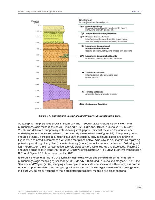
Figure 2-7. Stratigraphic Column showing Primary Hydrostratigraphic Units<br />
Stratigraphic interpretations shown in Figure 2-7 and in Section 2.4.3 (below) are consistent with<br />
published geologic maps of the basin (Birkeland, 1961; Birkeland, 1963; Saucedo, 2005; Melody,<br />
2009), and delineate four primary water-bearing stratigraphic units that make up the aquifer, and<br />
underlying rocks that are considered to be relatively water-limited (see Figure 2-9). The primary units<br />
shown in Figure 2-7 include a number of subunits mapped by previous investigators and shown on<br />
Figure 2-9 and noted in parenthesis with the descriptions below. When available, information regarding<br />
potentially confining (fine grained) or water-bearing (coarse) subunits are also delineated. Following well<br />
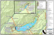
log interpretation, three representative geologic cross-sections were located and developed. Figure 2-9<br />
shows the cross-section locations; Figure 2-10 shows cross-section A-A’; Figure 2-11 shows cross-section<br />
B-B’, and Figure 2-12 shows cross-section C-C’.<br />
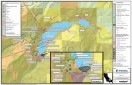
It should be noted that Figure 2-9, a geologic map of the MVGB and surrounding areas, is based on<br />
published geologic mapping by Saucedo (2005), Melody (2009), and Saucedo and Wagner (1992). The<br />
Saucedo and Wagner (2009) mapping was completed at a statewide scale and is therefore, less precise<br />
than other portions of the map and geological cross-sections. Accordingly, portions of the geologic map<br />
in Figure 2-9 do not correspond to the more detailed geological mapping and cross-sections.<br />
DRAFT for review purposes only. Use of contents on this sheet is subject to the limitations specified at the end of this document.<br />
P:\40000\140691 - PCWA <strong>Martis</strong> <strong>Valley</strong> GWP\GMP\Report\3rd Draft\<strong>Martis</strong> <strong>Valley</strong> GMP Draft 01-09-13.docx<br />
2-12