Martis Valley Groundwater Management Plan - Placer County Water ...
Martis Valley Groundwater Management Plan - Placer County Water ...
Martis Valley Groundwater Management Plan - Placer County Water ...

You also want an ePaper? Increase the reach of your titles
YUMPU automatically turns print PDFs into web optimized ePapers that Google loves.
<strong>Martis</strong> <strong>Valley</strong> <strong>Groundwater</strong> <strong>Management</strong> <strong>Plan</strong> Table of Contents<br />
List of Figures<br />
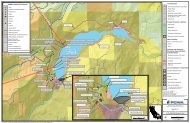
Figure 1-1. <strong>Groundwater</strong> <strong>Management</strong> <strong>Plan</strong> Area ....................................................................................... 1-2<br />
Figure 1-2. GMP Development Process ........................................................................................................ 1-4<br />
Figure 2-1. <strong>Groundwater</strong> Basin Location and Physiography ....................................................................... 2-2<br />
Figure 2-2. Mean Annual Precipitation ......................................................................................................... 2-3<br />
Figure 2-3. Mean Monthly Precipitation, Truckee Ranger Station, from 1904 to 1919 and<br />
1935 to 2009 ........................................................................................................................................... 2-4<br />
Figure 2-4. Percent Deviation from Mean Annual Precipitation at the Truckee Ranger Station<br />
and Total Annual Streamflow at Farad .................................................................................................... 2-5<br />
Figure 2-5. Hydrography and Long-Term Monitoring Stations .................................................................... 2-7<br />
Figure 2-6. Mean Monthly Streamflows in the Middle Truckee River <strong>Water</strong>shed ..................................... 2-9<br />
Figure 2-7. Stratigraphic Column showing Primary Hydrostratigraphic Units .......................................... 2-12<br />
Figure 2-8. Well Locations ........................................................................................................................... 2-13<br />
Figure 2-9. Geologic Map and Cross Section Locations ............................................................................ 2-14<br />
Figure 2-10. Cross-section A-A’ ................................................................................................................... 2-15<br />
Figure 2-11. Cross-section B-B’ .................................................................................................................... 2-16<br />
Figure 2-12. Cross-section C-C’ ................................................................................................................... 2-17<br />
Figure 2-13. Locations of Springs and Mapped Faults (active and inferred) ........................................... 2-19<br />
Figure 2-14a. Lousetown Volcanic Outcrop ............................................................................................... 2-21<br />
Figure 2-14b. Prosser Formation Outcrop Underlying Glacial Outwash ................................................... 2-21<br />
Figure 2-15. <strong>Water</strong> Levels in DWR Long-term <strong>Groundwater</strong> Monitoring Wells ........................................ 2-23<br />
Figure 2-16. Department of <strong>Water</strong> Resources Monitoring Wells and Select Hydrographs ..................... 2-24<br />
Figure 2-17. Depth Distribution of Wells in the <strong>Martis</strong> <strong>Valley</strong> <strong>Groundwater</strong> Basin .................................. 2-26<br />
Figure 2-18. Average Annual <strong>Groundwater</strong> Recharge 1988 to 2011 ...................................................... 2-29<br />
Figure 2-19. Annual <strong>Groundwater</strong> Recharge Dry Year 1988 .................................................................... 2-30<br />
Figure 2-20. Annual <strong>Groundwater</strong> Recharge Wet Year 1995 ................................................................... 2-31<br />
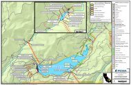
Figure 3-1. CASGEM and DWR <strong>Groundwater</strong> Monitoring Wells .................................................................. 3-8<br />
DRAFT for review purposes only. Use of contents on this sheet is subject to the limitations specified at the end of this document.<br />
<strong>Martis</strong> <strong>Valley</strong> GMP Draft 01-09-13.docx<br />
v