Martis Valley Groundwater Management Plan - Placer County Water ...
Martis Valley Groundwater Management Plan - Placer County Water ...
Martis Valley Groundwater Management Plan - Placer County Water ...

Create successful ePaper yourself
Turn your PDF publications into a flip-book with our unique Google optimized e-Paper software.
CASGEM Monitoring <strong>Plan</strong> Summary<br />
The goal of the CASGEM program is to regularly and systematically monitor<br />
groundwater elevations that demonstrate seasonal and long-term trends in California’s<br />
groundwater basins and to make this information readily and widely available to the<br />
public. The CASGEM program will rely and build on the many, established local longterm<br />
groundwater monitoring and management programs.<br />
In determining what information should be reported to DWR, the department will defer to<br />
existing monitoring programs if those programs result in information that demonstrates<br />
seasonal and long-term trends in groundwater elevations. Monitoring Entities may<br />
submit an existing groundwater monitoring plan that is part of a groundwater<br />
adjudication program, an AB3030 program, an IRWM program, or any other<br />
groundwater management program that satisfies the goals of CASGEM. If there are<br />
future changes in a monitoring plan that is already established with CASGEM, the<br />
Monitoring Entity should provide an update to DWR at that time.<br />
Monitoring <strong>Plan</strong> Overview<br />
Phase 2 of the CASGEM Online Submittal System will be available on May 18, 2011 for<br />
prospective Monitoring Entities to submit their groundwater elevation monitoring plans<br />
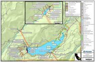
and detailed well information. Each CASGEM monitoring plan should describe the<br />
monitoring network and the monitoring plan rationale. The description of the well<br />
network should allow users of the CASGEM database to understand well coverage<br />
within the basin or subbasin. The monitoring plan rationale explains how the proposed<br />
monitoring is designed to capture the seasonal highs and lows and long-term<br />
groundwater elevation trends.<br />
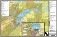
The basic components of a CASGEM monitoring plan include the following:<br />
• discussion of the well network,<br />
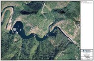
• map(s) of the well network,<br />
• monitoring schedule,<br />
• description of field methods,<br />
• discussion of the role of cooperating agencies, if applicable, and<br />
• description of the monitoring plan rationale.<br />
The monitoring rationale, which explains how the plan will result in groundwater<br />
elevation data that demonstrates seasonal and long-term trends, may discuss any or all<br />
of the following information:<br />
• history of groundwater monitoring in the basin,<br />
• principal aquifer features of the basin (for example, multiple aquifers),<br />
1