

Free Download - HCCREMS
Free Download - HCCREMS
Free Download - HCCREMS

You also want an ePaper? Increase the reach of your titles
YUMPU automatically turns print PDFs into web optimized ePapers that Google loves.
HClNC Vegetation Classification & mapping Project: Volume 1: Vegetation Classification Technical Report<br />
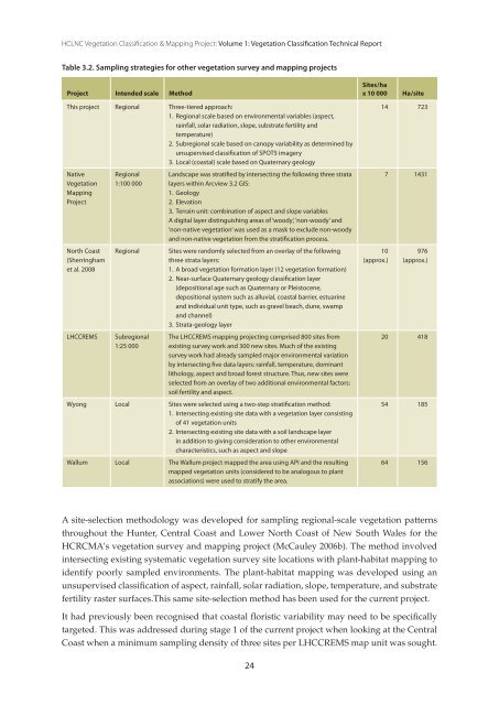
Table 3.2. Sampling strategies for other vegetation survey and mapping projects<br />
Project Intended scale Method<br />
This project Regional Three-tiered approach:<br />
1. Regional scale based on environmental variables (aspect,<br />
rainfall, solar radiation, slope, substrate fertility and<br />
temperature)<br />
2. Subregional scale based on canopy variability as determined by<br />
unsupervised classification of SPOT5 imagery<br />
3. Local (coastal) scale based on Quaternary geology<br />
Native<br />
Vegetation<br />
Mapping<br />
Project<br />
North Coast<br />
(Sherringham<br />
et al. 2008<br />
Regional<br />
1:100 000<br />
LHCCReMS Subregional<br />
1:25 000<br />
Landscape was stratified by intersecting the following three strata<br />
layers within arcview 3.2 GIS:<br />
1. Geology<br />
2. elevation<br />
3. Terrain unit: combination of aspect and slope variables<br />
a digital layer distinguishing areas of ‘woody’, ‘non-woody’ and<br />
‘non-native vegetation’ was used as a mask to exclude non-woody<br />
and non-native vegetation from the stratification process.<br />
Regional Sites were randomly selected from an overlay of the following<br />
three strata layers:<br />
1. a broad vegetation formation layer (12 vegetation formation)<br />
2. Near-surface Quaternary geology classification layer<br />
(depositional age such as Quaternary or Pleistocene,<br />
depositional system such as alluvial, coastal barrier, estuarine<br />
and individual unit type, such as gravel beach, dune, swamp<br />
and channel)<br />
3. Strata-geology layer<br />
The LHCCReMS mapping projecting comprised 800 sites from<br />
existing survey work and 300 new sites. Much of the existing<br />
survey work had already sampled major environmental variation<br />
by intersecting five data layers: rainfall, temperature, dominant<br />
lithology, aspect and broad forest structure. Thus, new sites were<br />
selected from an overlay of two additional environmental factors:<br />
soil fertility and aspect.<br />
Wyong Local Sites were selected using a two-step stratification method:<br />
1. Intersecting existing site data with a vegetation layer consisting<br />
of 41 vegetation units<br />
2. Intersecting existing site data with a soil landscape layer<br />
in addition to giving consideration to other environmental<br />
characteristics, such as aspect and slope<br />
Wallum Local The Wallum project mapped the area using aPI and the resulting<br />
mapped vegetation units (considered to be analogous to plant<br />
associations) were used to stratify the area.<br />
24<br />
Sites / ha<br />
x 10 000 Ha / site<br />
10<br />
(approx.)<br />
14 723<br />
7 1431<br />
976<br />
(approx.)<br />
20 418<br />
54 185<br />
64 156<br />
A site-selection methodology was developed for sampling regional-scale vegetation patterns<br />
throughout the Hunter, Central Coast and Lower North Coast of New South Wales for the<br />
HCRCMA’s vegetation survey and mapping project (McCauley 2006b). The method involved<br />
intersecting existing systematic vegetation survey site locations with plant-habitat mapping to<br />
identify poorly sampled environments. The plant-habitat mapping was developed using an<br />
unsupervised classification of aspect, rainfall, solar radiation, slope, temperature, and substrate<br />
fertility raster surfaces.This same site-selection method has been used for the current project.<br />
It had previously been recognised that coastal floristic variability may need to be specifically<br />
targeted. This was addressed during stage 1 of the current project when looking at the Central<br />
Coast when a minimum sampling density of three sites per L<strong>HCCREMS</strong> map unit was sought.