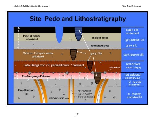
4th IUSS Soil Classification Conference <strong>Field</strong> Tour Guidebook Stratigraphic, Pedologic, and Paleo-Topographic Relationships on a Glaciated Upland Interfluve Near Lincoln, <strong>Nebraska</strong> Philip JJ. Schoeneberger* Schoeneberger and Douglas AA. Wysocki Wysocki, National Soil Survey Center Center, USDA - NRCS NRCS, Lincoln Lincoln, NE Introduction <strong>Soils</strong> are a synthograph, a record of earth system processes that can lead to an understanding of landscape history, soil geography, and the dynamic processes that formed them. These insights substantively explain what otherwise appears to be random soil variability, and can be applied to better manage soil Methods Fi Figure 22. Summary & Landscape History Site morphology and sediment body composition and configuration detail a dynamic, varied landscape history. The sequence of layers (from the surface down; Figure 5) are interpreted as: and water resources. 0) Anthropogenic land surface modification by removal of most of the modern mollic surface and exposure of headwalls (borrow-pit activities). Primary field observations were made along headwalls of an extensive borrowpit site cut through an interfluve of dissected till plains adjacent to Lincoln, <strong>Nebraska</strong> (Figure 1). Cross-sectional documentation is shown (Figure 2). Standard laboratory analyses were conducted on soil horizons (Burt, 2004). Results An upland interfluve was investigated in a loess-mantled, pre-Illinoian glaciated landscape near Lincoln, NE. The site retains a record of the stratigraphic, pedologic and paleo-topographic paleo topographic relationships of multiple depositional and soil development episodes over the last several hundred thousand years. The sequence of layers (from the surface down; Figure 3) are: 1) Greyish-brown loess [locally colluviated, homogeneous eolian-derived silt with scattered till-derived gravels, and an oxidized upper portion (including a black, modern mollic surface) and an intermittent, deoxidized lower portion]. 2) Brown loess (locally colluviated with scattered, till-derived gravels). 3) Pedisediment unit including a reddish-brown paleosol (reworked, loessderived slope alluvium, including scattered gravels and channel-fills, rather than primary air-fall loess deposits). 4) Stone line (erosional lag concentration of gravels and stones) 5) Glacial till (3 zones): a) A truncated, red paleosol developed in the uppermost portion of the leached, oxidized till. (weathered, reddish, strong pedogenic structure, leached, in an oxidized, till – derived matrix). b) Oxidized, leached till (weathered, weak pedo-geogenic structure, oxidized till matrix). c) Unoxidized, unleached till (Figure 4) (weathered, with strong geogenic structure, grey till matrix. The upper 5-10m of the till is dominated by prominent, deep polygonal fractures. The fractures are lined with a thin, black Mn / Fe-Mn film along the primary fracture face which is surrounded by white secondary CaCO3 , which is bounded by a thick yellow halo (hypocoats) of Fe and Mn oxides. These polygonal seams are nearly vertical at depth (>5-10m). Near the upper limit of the till the seams are vertical in proximity to the interfluve axis, but bend obliquely in a down-slope direction on sideslopes. Pit 6 Profile Description and Lab Data 1 Figure 1. Figure 4. Relative Horiz. Soil Co. Matrix Soil Structure Efferv. Depth (cm) (top 40 cm Texture Frags Frags. % Color (m) Class removed) -- -- -- -- -- -- 0-10 A sicl 1 10YR 3/1 3,f -m, abk NE 10-40 Bt1 sicl 0 10YR 4/3 & 5/3 2, m-c, sbk NE DEM of NW 27th & 5/3 40-70 Bt2 sicl 1 10YR 4/3 2, m, pr parts to 2, m, sbk NE 70-100 Bt3 sicl 2 7.5YR 4/3 1, co, pr parts to 1, m,sbk NE DEM of NW 27 St. Area 100-130 100 130 Bt4 sicl 2 5YR 3/3 11, mm-cc, pr prparts parts NE & 4/3 to 2, m, sbk 130-145 2Bt1 extr. gr. l 85 7.5YR 4/6 1, m NE Figure 3. Pit 6. 145-160 2Bt2 cl 7 7.5YR 4/6 2, m, sbk NE Figure 5. 160-210 3Bt cl 2 7.5YR 4/4 3 co-v.co pr parts to o 3, f-m, , sbk sb NE 210-230 3BC c 2 2.5Y 5/2 3 co-v.co pr parts to 3, f-m, sbk NE 230-260 3C c 2 2.5Y 5/2 3 co-v.co pr parts to 3, f-m, abk SL 260+ 1 Burt, 2004. -- c 2 2.5Y 5/2 3 co-v.co pr p parts p to 3, f-m, abk SL References Burt, R. 2004. Soil Survey Laboratory Methods Manual, ver. 4.0. USDA- NRCS, SSIR 42. Mason, J.A., Joeckle, R.M., Bettis, E.A. III. 2007. Middle to late Pleistocence loess record in eastern <strong>Nebraska</strong>, USA, and implications for the unique nature of Oxygen isotope Stage 2. Quaternary Science Reviews: 26 pp. 773-792. USDA is an equal opportunity provider and employer 28 1) Peoria-aged* loess (>11 to 20 to 50 to 640 ka (Lava Creek –B tephra) to
4th IUSS Soil Classification Conference <strong>Field</strong> Tour Guidebook 29