

Ground-water development in East St. Louis area, Illinois. Urbana, IL ...
Ground-water development in East St. Louis area, Illinois. Urbana, IL ...
Ground-water development in East St. Louis area, Illinois. Urbana, IL ...

You also want an ePaper? Increase the reach of your titles
YUMPU automatically turns print PDFs into web optimized ePapers that Google loves.
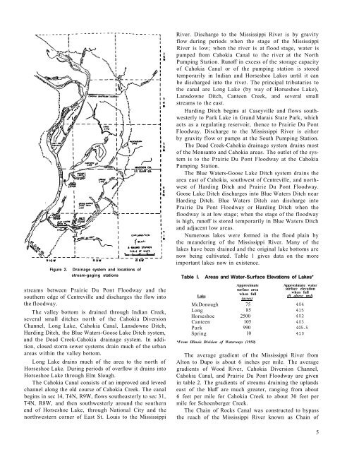
Figure 2.<br />
Dra<strong>in</strong>age system and locations of<br />
stream-gag<strong>in</strong>g stations<br />
streams between Prairie Du Pont Floodway and the<br />
southern edge of Centreville and discharges the flow <strong>in</strong>to<br />
the floodway.<br />
The valley bottom is dra<strong>in</strong>ed through Indian Creek,<br />
several small ditches north of the Cahokia Diversion<br />
Channel, Long Lake, Cahokia Canal, Lansdowne Ditch,<br />
Hard<strong>in</strong>g Ditch, the Blue Waters-Goose Lake Ditch system,<br />
and the Dead Creek-Cahokia dra<strong>in</strong>age system. In addition,<br />
closed storm sewer systems dra<strong>in</strong> much of the urban<br />
<strong>area</strong>s with<strong>in</strong> the valley bottom.<br />
Long Lake dra<strong>in</strong>s much of the <strong>area</strong> to the north of<br />
Horseshoe Lake. Dur<strong>in</strong>g periods of overflow it dra<strong>in</strong>s <strong>in</strong>to<br />
Horseshoe Lake through Elm Slough.<br />
The Cahokia Canal consists of an improved and leveed<br />
channel along the old course of Cahokia Creek. The canal<br />
beg<strong>in</strong>s <strong>in</strong> sec 14, T4N, R9W, flows southeasterly to sec 31,<br />
T4N, R8W, and then southwesterly around the southern<br />
end of Horseshoe Lake, through National City and the<br />
northwestern corner of <strong>East</strong> <strong>St</strong>. <strong>Louis</strong> to the Mississippi<br />
River. Discharge to the Mississippi River is by gravity<br />
flow dur<strong>in</strong>g periods when the stage of the Mississippi<br />
River is low; when the river is at flood stage, <strong>water</strong> is<br />
pumped from Cahokia Canal to the river at the North<br />
Pump<strong>in</strong>g <strong>St</strong>ation. Runoff <strong>in</strong> excess of the storage capacity<br />
of Cahokia Canal or of the pump<strong>in</strong>g station is stored<br />
temporarily <strong>in</strong> Indian and Horseshoe Lakes until it can<br />
be discharged <strong>in</strong>to the river. The pr<strong>in</strong>cipal tributaries to<br />
the canal are Long Lake (by way of Horseshoe Lake),<br />
Lansdowne Ditch, Canteen Creek, and several small<br />
streams to the east.<br />
Hard<strong>in</strong>g Ditch beg<strong>in</strong>s at Caseyville and flows southwesterly<br />
to Park Lake <strong>in</strong> Grand Marais <strong>St</strong>ate Park, which<br />
acts as a regulat<strong>in</strong>g reservoir, thence to Prairie Du Pont<br />
Floodway. Discharge to the Mississippi River is either<br />
by gravity flow or pumps at the South Pump<strong>in</strong>g <strong>St</strong>ation.<br />
The Dead Creek-Cahokia dra<strong>in</strong>age system dra<strong>in</strong>s most<br />
of the Monsanto and Cahokia <strong>area</strong>s. The outlet of the system<br />
is to the Prairie Du Pont Floodway at the Cahokia<br />
Pump<strong>in</strong>g <strong>St</strong>ation.<br />
The Blue Waters-Goose Lake Ditch system dra<strong>in</strong>s the<br />
<strong>area</strong> east of Cahokia, southwest of Centreville, and northwest<br />
of Hard<strong>in</strong>g Ditch and Prairie Du Pont Floodway.<br />
Goose Lake Ditch discharges <strong>in</strong>to Blue Waters Ditch near<br />
Hard<strong>in</strong>g Ditch. Blue Waters Ditch can discharge <strong>in</strong>to<br />
Prairie Du Pont Floodway or Hard<strong>in</strong>g Ditch when the<br />
floodway is at low stage; when the stage of the floodway<br />
is high, runoff is stored temporarily <strong>in</strong> Blue Waters Ditch<br />
and adjacent low <strong>area</strong>s.<br />
Numerous lakes were formed <strong>in</strong> the flood pla<strong>in</strong> by<br />
the meander<strong>in</strong>g of the Mississippi River. Many of the<br />
lakes have been dra<strong>in</strong>ed and the orig<strong>in</strong>al lake bottoms are<br />
now be<strong>in</strong>g cultivated. Table 1 gives data on the more<br />
important lakes now <strong>in</strong> existence.<br />
Table I.<br />
Lake<br />
McDonough<br />
Long<br />
Horseshoe<br />
Canteen<br />
Park<br />
Spr<strong>in</strong>g<br />
Areas and Water-Surface Elevations of Lakes*<br />
Approximate<br />
surface <strong>area</strong><br />
when full<br />
(acres)<br />
75<br />
85<br />
2500<br />
105<br />
990<br />
10<br />
*From Ill<strong>in</strong>ois Division of Waterways (1950)<br />
Approximate <strong>water</strong><br />
surface elevation<br />
when full<br />
(ft above msl)<br />
404<br />
415<br />
402<br />
403<br />
405.5<br />
410<br />
The average gradient of the Mississippi River from<br />
Alton to Dupo is about 6 <strong>in</strong>ches per mile. The average<br />
gradients of Wood River, Cahokia Diversion Channel,<br />
Cahokia Canal, and Prairie Du Pont Floodway are given<br />
<strong>in</strong> table 2. The gradients of streams dra<strong>in</strong><strong>in</strong>g the uplands<br />
east of the bluff are much greater, rang<strong>in</strong>g from about<br />
6 feet per mile for Cahokia Creek to about 30 feet per<br />
mile for Schoenberger Creek.<br />
The Cha<strong>in</strong> of Rocks Canal was constructed to bypass<br />
the reach of the Mississippi River known as Cha<strong>in</strong> of<br />
5


