

Ground-water development in East St. Louis area, Illinois. Urbana, IL ...
Ground-water development in East St. Louis area, Illinois. Urbana, IL ...
Ground-water development in East St. Louis area, Illinois. Urbana, IL ...

Create successful ePaper yourself
Turn your PDF publications into a flip-book with our unique Google optimized e-Paper software.
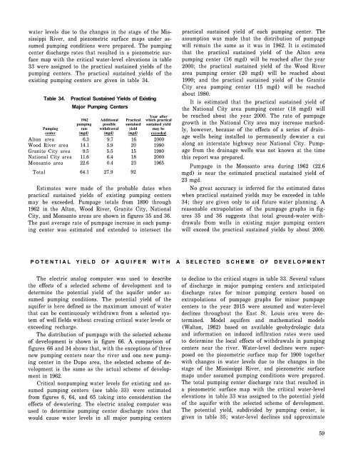
<strong>water</strong> levels due to the changes <strong>in</strong> the stage of the Mississippi<br />
River, and piezometric surface maps under assumed<br />
pump<strong>in</strong>g conditions were prepared. The pump<strong>in</strong>g<br />
center discharge rates that resulted <strong>in</strong> a piezometric surface<br />
map with the critical <strong>water</strong>-level elevations <strong>in</strong> table<br />
33 were assigned to the practical susta<strong>in</strong>ed yields of the<br />
pump<strong>in</strong>g centers. The practical susta<strong>in</strong>ed yields of the<br />
exist<strong>in</strong>g pump<strong>in</strong>g centers are given <strong>in</strong> table 34.<br />
Table 34.<br />
Practical Susta<strong>in</strong>ed Yields of Exist<strong>in</strong>g<br />
Major Pump<strong>in</strong>g Centers<br />
Year after<br />
1962 Additional Practical which practical<br />
pump<strong>in</strong>g possible susta<strong>in</strong>ed susta<strong>in</strong>ed yield<br />
Pump<strong>in</strong>g rate withdrawal yield may be<br />
center (mgd) (mgd) (mgd) exceeded<br />
Alton <strong>area</strong> 6.3 9.7 16 2000<br />
Wood River <strong>area</strong> 14.1 5.9 20 1990<br />
Granite City <strong>area</strong> 9.5 5.5 15 1980<br />
National City <strong>area</strong> 11.6 6.4 18 2000<br />
Monsanto <strong>area</strong> 22.6 0.4 23 1965<br />
Total 64.1 27.9 92<br />
Estimates were made of the probable dates when<br />
practical susta<strong>in</strong>ed yields of exist<strong>in</strong>g pump<strong>in</strong>g centers<br />
may be exceeded. Pumpage totals from 1890 through<br />
1962 <strong>in</strong> the Alton, Wood River, Granite City, National<br />
City, and Monsanto <strong>area</strong>s are shown <strong>in</strong> figures 35 and 36.<br />
The past average rate of pumpage <strong>in</strong>crease <strong>in</strong> each pump<strong>in</strong>g<br />
center was estimated and extended to <strong>in</strong>tersect the<br />
practical susta<strong>in</strong>ed yield of each pump<strong>in</strong>g center. The<br />
assumption was made that the distribution of pumpage<br />
will rema<strong>in</strong> the same as it was <strong>in</strong> 1962. It is estimated<br />
that the practical susta<strong>in</strong>ed yield of the Alton <strong>area</strong><br />
pump<strong>in</strong>g center (16 mgd) will be reached after the year<br />
2000; the practical susta<strong>in</strong>ed yield of the Wood River<br />
<strong>area</strong> pump<strong>in</strong>g center (20 mgd) will be reached about<br />
1990; and the practical susta<strong>in</strong>ed yield of the Granite<br />
City <strong>area</strong> pump<strong>in</strong>g center (15 mgd) will be reached<br />
about 1980.<br />
It is estimated that the practical susta<strong>in</strong>ed yield of<br />
the National City <strong>area</strong> pump<strong>in</strong>g center (18 mgd) will<br />
be reached about the year 2000. The rate of pumpage<br />
growth <strong>in</strong> the National City <strong>area</strong> may <strong>in</strong>crease markedly,<br />
however, because of the effects of a series of dra<strong>in</strong>age<br />
wells be<strong>in</strong>g <strong>in</strong>stalled to permanently de<strong>water</strong> a cut<br />
along an <strong>in</strong>terstate highway near National City. Pumpage<br />
from the dra<strong>in</strong>age wells was not known at the time<br />
this report was prepared.<br />
Pumpage <strong>in</strong> the Monsanto <strong>area</strong> dur<strong>in</strong>g 1962 (22.6<br />
mgd) is near the estimated practical susta<strong>in</strong>ed yield of<br />
23 mgd.<br />
No great accuracy is <strong>in</strong>ferred for the estimated dates<br />
when practical susta<strong>in</strong>ed yields may be exceeded <strong>in</strong> table<br />
34; they are given only to aid future <strong>water</strong> plann<strong>in</strong>g. A<br />
reasonable extrapolation of the pumpage graphs <strong>in</strong> figures<br />
35 and 36 suggests that total ground-<strong>water</strong> withdrawals<br />
from wells <strong>in</strong> exist<strong>in</strong>g major pump<strong>in</strong>g centers<br />
will exceed the practical susta<strong>in</strong>ed yields by about 2000.<br />
POTENTIAL YIELD OF AQUIFER WITH A SELECTED SCHEME OF DEVELOPMENT<br />
The electric analog computer was used to describe<br />
the effects of a selected scheme of <strong>development</strong> and to<br />
determ<strong>in</strong>e the potential yield of the aquifer under assumed<br />
pump<strong>in</strong>g conditions. The potential yield of the<br />
aquifer is here def<strong>in</strong>ed as the maximum amount of <strong>water</strong><br />
that can be cont<strong>in</strong>uously withdrawn from a selected system<br />
of well fields without creat<strong>in</strong>g critical <strong>water</strong> levels or<br />
exceed<strong>in</strong>g recharge.<br />
The distribution of pumpage with the selected scheme<br />
of <strong>development</strong> is shown <strong>in</strong> figure 66. A comparison of<br />
figures 66 and 34 shows that, with the exceptions of three<br />
new pump<strong>in</strong>g centers near the river and one new pump<strong>in</strong>g<br />
center <strong>in</strong> the Dupo <strong>area</strong>, the selected scheme of <strong>development</strong><br />
is the same as the actual scheme of <strong>development</strong><br />
<strong>in</strong> 1962.<br />
Critical nonpump<strong>in</strong>g <strong>water</strong> levels for exist<strong>in</strong>g and assumed<br />
pump<strong>in</strong>g centers (see table 33) were estimated<br />
from figures 6, 64, and 65 tak<strong>in</strong>g <strong>in</strong>to consideration the<br />
effects of de<strong>water</strong><strong>in</strong>g. The electric analog computer was<br />
used to determ<strong>in</strong>e pump<strong>in</strong>g center discharge rates that<br />
would cause <strong>water</strong> levels <strong>in</strong> all major pump<strong>in</strong>g centers<br />
to decl<strong>in</strong>e to the critical stages <strong>in</strong> table 33. Several values<br />
of discharge <strong>in</strong> major pump<strong>in</strong>g centers and anticipated<br />
discharge rates for m<strong>in</strong>or pump<strong>in</strong>g centers based on<br />
extrapolations of pumpage graphs for m<strong>in</strong>or pumpage<br />
centers to the year 2015 were assumed and <strong>water</strong>-level<br />
decl<strong>in</strong>es throughout the <strong>East</strong> <strong>St</strong>. <strong>Louis</strong> <strong>area</strong> were determ<strong>in</strong>ed.<br />
Model aquifers and mathematical models<br />
(Walton, 1962) based on available geohydrologic data<br />
and <strong>in</strong>formation on <strong>in</strong>duced <strong>in</strong>filtration rates were used<br />
to determ<strong>in</strong>e the local effects of withdrawals <strong>in</strong> pump<strong>in</strong>g<br />
centers near the river. Water-level decl<strong>in</strong>es were superposed<br />
on the piezometric surface map for 1900 together<br />
with changes <strong>in</strong> <strong>water</strong> levels due to the changes <strong>in</strong> the<br />
stage of the Mississippi River, and piezometric surface<br />
maps under assumed pump<strong>in</strong>g conditions were prepared.<br />
The total pump<strong>in</strong>g center discharge rate that resulted <strong>in</strong><br />
a piezometric surface map with the critical <strong>water</strong>-level<br />
elevations <strong>in</strong> table 33 was assigned to the potential yield<br />
of the aquifer with the selected scheme of <strong>development</strong>.<br />
The potential yield, subdivided by pump<strong>in</strong>g center, is<br />
given <strong>in</strong> table 35; <strong>water</strong>-level decl<strong>in</strong>es and approximate<br />
59


