

Ground-water development in East St. Louis area, Illinois. Urbana, IL ...
Ground-water development in East St. Louis area, Illinois. Urbana, IL ...
Ground-water development in East St. Louis area, Illinois. Urbana, IL ...

You also want an ePaper? Increase the reach of your titles
YUMPU automatically turns print PDFs into web optimized ePapers that Google loves.
about 8 days a year have 3 <strong>in</strong>ches or more, of ground<br />
snow cover.<br />
Based on records collected at Lambert Field, the mean<br />
annual temperature is 56.4 F. June, July, and August are<br />
the hottest months with mean temperatures of 75.2, 79.6,<br />
and 77.8 F, respectively. January is the coldest month<br />
with a mean temperature of 32.1 F. The mean length of<br />
the grow<strong>in</strong>g season is 198 days.<br />
A large part of central and southern Ill<strong>in</strong>ois, <strong>in</strong>clud<strong>in</strong>g<br />
the <strong>East</strong> <strong>St</strong>. <strong>Louis</strong> <strong>area</strong>, experienced a severe drought<br />
beg<strong>in</strong>n<strong>in</strong>g <strong>in</strong> the latter part of 1952 (Hudson and Roberts,<br />
1955). For the period 1953 through 1956, cumulative deficiency<br />
of precipitation at Edwardsville and Lambert<br />
Field was about 22 and 34 <strong>in</strong>ches, respectively.<br />
An <strong>in</strong>tense ra<strong>in</strong>storm, exceed<strong>in</strong>g 16 <strong>in</strong>ches <strong>in</strong> 12 hours<br />
at places, occurred June 14 and 15, 1957. The storm is<br />
discussed <strong>in</strong> detail by Huff et al. (1958). A Heavy ra<strong>in</strong>storm<br />
also occurred August 14-15, 1946, when over 11<br />
<strong>in</strong>ches were recorded at <strong>East</strong> <strong>St</strong>. <strong>Louis</strong>.<br />
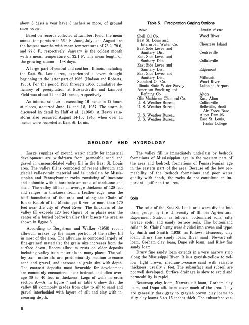
Owner<br />
Table 5. Precipitation Gag<strong>in</strong>g <strong>St</strong>ations<br />
Shell Oil Co.<br />
<strong>East</strong> <strong>St</strong>. <strong>Louis</strong> and<br />
Interurban Water Co.<br />
<strong>East</strong> Side Levee and<br />
Sanitary Dist.<br />
<strong>East</strong> Side Levee and<br />
Sanitary Dist.<br />
<strong>East</strong> Side Levee and<br />
Sanitary Dist.<br />
<strong>East</strong> Side Levee and<br />
Sanitary Dist.<br />
<strong>St</strong>andard Oil Co.<br />
Ill<strong>in</strong>ois <strong>St</strong>ate Water Survey<br />
American Smelt<strong>in</strong>g and<br />
Ref<strong>in</strong><strong>in</strong>g Co.<br />
Ol<strong>in</strong> Mathieson Chemical Co.<br />
U. S. Weather Bureau<br />
U. S. Weather Bureau<br />
U. S. Weather Bureau<br />
U. S. Weather Bureau<br />
Location of gage<br />
Wood River<br />
Chouteau Island<br />
Centreville<br />
Coll<strong>in</strong>sville<br />
Edgemont<br />
Millstadt<br />
Wood River<br />
Lakeside Airport<br />
Alton<br />
<strong>East</strong> Alton<br />
Coll<strong>in</strong>sville<br />
Belleville, Scott<br />
Air Force Base<br />
Alton Dam 26<br />
<strong>East</strong> <strong>St</strong>. <strong>Louis</strong>,<br />
Parks College<br />
GEOLOGY AND HYDROLOGY<br />
Large supplies of ground <strong>water</strong> chiefly for <strong>in</strong>dustrial<br />
<strong>development</strong> are withdrawn from permeable sand and<br />
gravel <strong>in</strong> unconsolidated valley fill <strong>in</strong> the <strong>East</strong> <strong>St</strong>. <strong>Louis</strong><br />
<strong>area</strong>. The valley fill is composed of recent alluvium and<br />
glacial valley-tra<strong>in</strong> material and is underla<strong>in</strong> by Mississippian<br />
and Pennsylvanian rocks consist<strong>in</strong>g of limestone<br />
and dolomite with subord<strong>in</strong>ate amounts of sandstone and<br />
shale. The valley fill has an average thickness of 120 feet<br />
and ranges <strong>in</strong> thickness from a feather edge, near the<br />
bluff boundaries of the <strong>area</strong> and along the Cha<strong>in</strong> of<br />
Rocks Reach of the Mississippi River, to more than 170<br />
feet near the city of Wood River. The thickness of the<br />
valley fill exceeds 120 feet (figure 5) <strong>in</strong> places near the<br />
center of a buried bedrock valley that bisects the <strong>area</strong> as<br />
shown <strong>in</strong> figure 6.<br />
Accord<strong>in</strong>g to Bergstrom and Walker (1956) recent<br />
alluvium makes up the major portion of the valley fill<br />
<strong>in</strong> most of the <strong>area</strong>. The alluvium is composed largely of<br />
f<strong>in</strong>e-gra<strong>in</strong>ed materials; the gra<strong>in</strong> size <strong>in</strong>creases from the<br />
surface down. Recent alluvium rests on older deposits<br />
<strong>in</strong>clud<strong>in</strong>g valley-tra<strong>in</strong> materials <strong>in</strong> many places. The valley-tra<strong>in</strong><br />
materials are predom<strong>in</strong>antly medium-to-coarse<br />
sand and gravel, and <strong>in</strong>crease <strong>in</strong> gra<strong>in</strong> size with depth.<br />
The coarsest deposits most favorable for <strong>development</strong><br />
are commonly encountered near bedrock and often average<br />
30 to 40 feet <strong>in</strong> thickness. Logs of wells <strong>in</strong> cross<br />
section A—A' <strong>in</strong> figure 7 and <strong>in</strong> table 6 show that the<br />
valley fill commonly grades from clay to silt to sand and<br />
gravel <strong>in</strong>terbedded with layers of silt and clay with <strong>in</strong>creas<strong>in</strong>g<br />
depth.<br />
The valley fill is immediately underla<strong>in</strong> by bedrock<br />
formations of Mississippian age <strong>in</strong> the western part of<br />
the <strong>area</strong> and bedrock formations of Pennsylvanian age<br />
<strong>in</strong> the eastern part of the <strong>area</strong>. Because of the low permeability<br />
of the bedrock formations and poor <strong>water</strong><br />
quality with depth, the rocks do not constitute an important<br />
aquifer <strong>in</strong> the <strong>area</strong>.<br />
Soils<br />
The soils of the <strong>East</strong> <strong>St</strong>. <strong>Louis</strong> <strong>area</strong> were divided <strong>in</strong>to<br />
three groups by the University of Ill<strong>in</strong>ois Agricultural<br />
Experiment <strong>St</strong>ation as follows: bottomland soils, silty<br />
terrace soils, and sandy terrace soils. The bottomland<br />
soils <strong>in</strong> <strong>St</strong>. Clair County were divided <strong>in</strong>to seven soil types<br />
by Smith and Smith (1938) as follows: Beaucoup clay<br />
loam, Drury f<strong>in</strong>e sandy loam, River sand, Newart silt<br />
loam, Gorham clay loam, Dupo silt loam, and Riley f<strong>in</strong>e<br />
sandy loam.<br />
Drury f<strong>in</strong>e sandy loam extends <strong>in</strong> a very narrow strip<br />
along the Mississippi River. It is a grayish-yellow to yellow,<br />
light brown, medium-to-coarse sand with variable<br />
thickness, usually 7 feet. The subsurface and subsoil are<br />
not well developed. Surface dra<strong>in</strong>age is slow to rapid and<br />
permeability is rapid.<br />
Beaucoup clay loam, Newart silt loam, Gorham clay<br />
loam, and Dupo silt loam cover much of the <strong>area</strong>. They<br />
are generally dark gray to grayish brown clay loams to<br />
silty clay loams 6 to 15 <strong>in</strong>ches thick. The subsurface var-<br />
8


