

Ground-water development in East St. Louis area, Illinois. Urbana, IL ...
Ground-water development in East St. Louis area, Illinois. Urbana, IL ...
Ground-water development in East St. Louis area, Illinois. Urbana, IL ...

You also want an ePaper? Increase the reach of your titles
YUMPU automatically turns print PDFs into web optimized ePapers that Google loves.
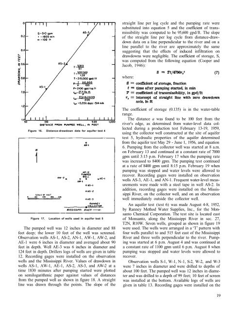
straight l<strong>in</strong>e per log cycle and the pump<strong>in</strong>g rate were<br />
substituted <strong>in</strong>to equation 5 and the coefficient of transmissibility<br />
was computed to be 95,600 gpd/ft. The slope<br />
of the straight l<strong>in</strong>e per log cycle from distance-drawdown<br />
data on a l<strong>in</strong>e perpendicular to the river and on a<br />
l<strong>in</strong>e parallel to the river are approximately the same<br />
suggest<strong>in</strong>g that the effects of <strong>in</strong>duced <strong>in</strong>filtration on<br />
drawdowns were negligible. The coefficient of storage, S,<br />
was computed from the follow<strong>in</strong>g equation (Cooper and<br />
Jacob, 1946):<br />
where:<br />
(7)<br />
Figure 16. Distance-drawdown data for aquifer test 4<br />
Figure 17. Location of wells used <strong>in</strong> aquifer test 5<br />
The pumped well was 12 <strong>in</strong>ches <strong>in</strong> diameter and 88<br />
feet deep; the lower 10 feet of the well was screened.<br />
Observation wells AS-1, AS-2, AN-1, AW-1, AW-2, and<br />
AE-1 were 6 <strong>in</strong>ches <strong>in</strong> diameter and averaged about 90<br />
feet <strong>in</strong> depth. Well AE-3 was 6 <strong>in</strong>ches <strong>in</strong> diameter and<br />
124 feet <strong>in</strong> depth. Drillers logs of wells are given <strong>in</strong> table<br />
12. Record<strong>in</strong>g gages were <strong>in</strong>stalled on the observation<br />
wells and the Mississippi River. Values of drawdown <strong>in</strong><br />
wells AS-1, AW-1, AE-1, AS-2, AS-3, and AW-2 at a<br />
time 1830 m<strong>in</strong>utes after pump<strong>in</strong>g started were plotted<br />
on semilogarithmic paper aga<strong>in</strong>st values of distances<br />
from the pumped well as shown <strong>in</strong> figure 18. A straight<br />
l<strong>in</strong>e was drawn through the po<strong>in</strong>ts. The slope of the<br />
The coefficient of storage (0.135) is <strong>in</strong> the <strong>water</strong>-table<br />
range.<br />
The distance a was found to be 100 feet from the<br />
river's edge, as determ<strong>in</strong>ed from <strong>water</strong>-level data collected<br />
dur<strong>in</strong>g a production test February 13-19, 1959,<br />
us<strong>in</strong>g the collector well constructed at the site of aquifer<br />
test 5, hydraulic properties of the aquifer determ<strong>in</strong>ed<br />
from the aquifer test May 29 - June 1, 1956, and equation<br />
6. Pump<strong>in</strong>g from the collector well was started at 8 a.m.<br />
on February 13 and cont<strong>in</strong>ued at a constant rate of 7000<br />
gpm until 3:15 p.m. February 17 when the pump<strong>in</strong>g rate<br />
was <strong>in</strong>creased to 8400 gpm. The pump<strong>in</strong>g test cont<strong>in</strong>ued<br />
at a rate of 8400 gpm until 8:15 p.m. February 19 when<br />
pump<strong>in</strong>g was stopped and <strong>water</strong> levels were allowed to<br />
recover. Record<strong>in</strong>g gages were <strong>in</strong>stalled on observation<br />
wells AS-3, AE-1, and AN-1. Frequent <strong>water</strong>-level measurements<br />
were made with a steel tape <strong>in</strong> well AS-2. In<br />
addition, record<strong>in</strong>g gages were <strong>in</strong>stalled on the Mississippi<br />
River, on the collector well, and on an observation<br />
well immediately outside the collector well.<br />
An aquifer test (test 6) was made August 4-8, 1952,<br />
by Ranney Method Water Supplies, Inc., for the Monsanto<br />
Chemical Corporation. The test site is located east<br />
of Monsanto, along the Mississippi River <strong>in</strong> sec. 27,<br />
T2N, R10W. Seven wells, grouped as shown <strong>in</strong> figure 19<br />
were used. The wells were arranged <strong>in</strong> a ‘T’ pattern with<br />
four wells parallel to and 515 feet east of the Mississippi<br />
River and three wells perpendicular to the river. Pump<strong>in</strong>g<br />
was started at 6 p.m. August 4 and was cont<strong>in</strong>ued at<br />
a constant rate of 1100 gpm until 6 p.m. August 8 when<br />
pump<strong>in</strong>g was stopped and <strong>water</strong> levels were allowed to<br />
recover.<br />
Observation wells S-1, W-1, N-1, S-2, W-2, and W-3<br />
were 7 <strong>in</strong>ches <strong>in</strong> diameter and were drilled to depths of<br />
about 100 feet. The pumped well was 12 <strong>in</strong>ches <strong>in</strong> diameter<br />
and was drilled to a depth of 99 feet; 10 feet of screen<br />
was <strong>in</strong>stalled at the bottom. Available logs of wells are<br />
given <strong>in</strong> table 13. Record<strong>in</strong>g gages were <strong>in</strong>stalled on the<br />
19


