

Ground-water development in East St. Louis area, Illinois. Urbana, IL ...
Ground-water development in East St. Louis area, Illinois. Urbana, IL ...
Ground-water development in East St. Louis area, Illinois. Urbana, IL ...

Create successful ePaper yourself
Turn your PDF publications into a flip-book with our unique Google optimized e-Paper software.
Table 6 (Cont<strong>in</strong>ued)<br />
Sand, very coarse to coarse, with<br />
granule gravel, p<strong>in</strong>kish cast,<br />
abundant p<strong>in</strong>k-sta<strong>in</strong>ed quartz<br />
gra<strong>in</strong>s, subangular to subrounded<br />
gra<strong>in</strong>s<br />
Sand, medium, well sorted, p<strong>in</strong>k,<br />
subrounded to subangular gra<strong>in</strong>s,<br />
abundant p<strong>in</strong>k feldspar<br />
*From Bergstrom and Walker (1956)<br />
Thickness<br />
(ft)<br />
15<br />
5<br />
Depth<br />
(ft)<br />
110<br />
115<br />
ies from silty loam to clay and is generally 2 to 3 feet<br />
thick. The subsoil is not well developed. The permeability<br />
and surface dra<strong>in</strong>age is generally slow; the permeability<br />
of Newart silt loam is moderate.<br />
Riley f<strong>in</strong>e sandy loam covers much of the <strong>area</strong> near<br />
Monsanto, Cahokia, and Centreville. It is a light brown,<br />
f<strong>in</strong>e sandy loam 8 to 10 <strong>in</strong>ches thick. The subsurface is<br />
a loamy f<strong>in</strong>e sand 8 to 12 <strong>in</strong>ches thick, and the subsoil<br />
is a f<strong>in</strong>e sandy loam with occasional clay lenses. Surface<br />
dra<strong>in</strong>age is moderate to rapid and permeability is moderately<br />
rapid.<br />
Drury f<strong>in</strong>e sandy loam is a brownish yellow to yellowish<br />
silt loam to very f<strong>in</strong>e sandy loam and is variable <strong>in</strong><br />
thickness. It extends along the bluff <strong>in</strong> strips vary<strong>in</strong>g <strong>in</strong><br />
width from a few feet to several miles. The subsurface<br />
is a silt loam to sandy loam about 3 feet thick. The subsoil<br />
is not well developed. Surface dra<strong>in</strong>age is rapid and<br />
permeability is moderately rapid.<br />
The soils <strong>in</strong> the <strong>East</strong> <strong>St</strong>. <strong>Louis</strong> <strong>area</strong> <strong>in</strong> Madison County<br />
have not been divided <strong>in</strong>to soil types. Accord<strong>in</strong>g to Mc-<br />
Kenzie and Fehrenbacher (1961) bottomland soils predom<strong>in</strong>ate;<br />
however, silty terrace soils extend <strong>in</strong> a narrow<br />
strip along the bluffs just south of Cahokia Creek to the<br />
Madison-<strong>St</strong>. Clair County l<strong>in</strong>e, and <strong>in</strong> an <strong>area</strong> that extends<br />
from just south of Wood River southeast through<br />
Roxana and term<strong>in</strong>ates a few miles southeast of Roxana.<br />
Sandy terrace soils extend <strong>in</strong> a strip a few miles wide<br />
from <strong>East</strong> Alton to Wood River and <strong>in</strong> a narrow strip<br />
southeast of Poag to about 3 miles northwest of Glen Carbon<br />
; sandy terrace soils also occur <strong>in</strong> an <strong>area</strong> southeast of<br />
Roxana.<br />
The bottomland soils <strong>in</strong> Madison County exhibit a<br />
wide range of characteristics similar to those of the soil<br />
types <strong>in</strong> <strong>St</strong>. Clair County. The silty terrace and sandy<br />
terrace soils have moderately good to good dra<strong>in</strong>age and<br />
moderately rapid to rapid permeability.<br />
coarser alluvium and valley-tra<strong>in</strong> deposits; <strong>water</strong> <strong>in</strong> these<br />
deposits is under artesian pressure. Under leaky artesian<br />
conditions, <strong>water</strong> levels <strong>in</strong> wells rise above the top of the<br />
valley-tra<strong>in</strong> and coarse alluvium deposits to stages with<strong>in</strong><br />
the f<strong>in</strong>er gra<strong>in</strong>ed alluvium. Water-table conditions prevail<br />
at many places where alluvium is miss<strong>in</strong>g and the<br />
upper surface of the zone of saturation is <strong>in</strong> valley-tra<strong>in</strong><br />
deposits or the coarser alluvium, and at places with<strong>in</strong><br />
deep cones of depression created by heavy pump<strong>in</strong>g where<br />
<strong>water</strong> levels <strong>in</strong> wells rise to stages with<strong>in</strong> the valley-tra<strong>in</strong><br />
deposits or the coarser alluvium and <strong>water</strong> is unconf<strong>in</strong>ed.<br />
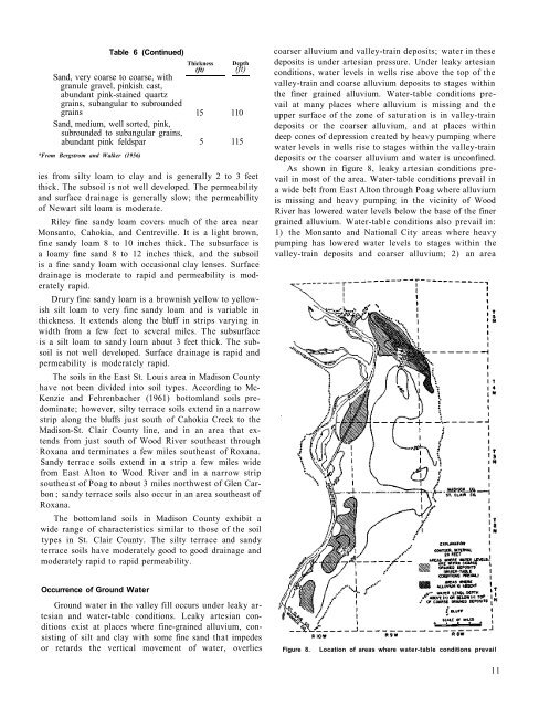
As shown <strong>in</strong> figure 8, leaky artesian conditions prevail<br />
<strong>in</strong> most of the <strong>area</strong>. Water-table conditions prevail <strong>in</strong><br />
a wide belt from <strong>East</strong> Alton through Poag where alluvium<br />
is miss<strong>in</strong>g and heavy pump<strong>in</strong>g <strong>in</strong> the vic<strong>in</strong>ity of Wood<br />
River has lowered <strong>water</strong> levels below the base of the f<strong>in</strong>er<br />
gra<strong>in</strong>ed alluvium. Water-table conditions also prevail <strong>in</strong>:<br />
1) the Monsanto and National City <strong>area</strong>s where heavy<br />
pump<strong>in</strong>g has lowered <strong>water</strong> levels to stages with<strong>in</strong> the<br />
valley-tra<strong>in</strong> deposits and coarser alluvium; 2) an <strong>area</strong><br />
Occurrence of <strong>Ground</strong> Water<br />
<strong>Ground</strong> <strong>water</strong> <strong>in</strong> the valley fill occurs under leaky artesian<br />
and <strong>water</strong>-table conditions. Leaky artesian conditions<br />
exist at places where f<strong>in</strong>e-gra<strong>in</strong>ed alluvium, consist<strong>in</strong>g<br />
of silt and clay with some f<strong>in</strong>e sand that impedes<br />
or retards the vertical movement of <strong>water</strong>, overlies<br />
Figure 8.<br />
Location of <strong>area</strong>s where <strong>water</strong>-table conditions prevail<br />
11


