

CITY OF DES MOINES SHORELINE MASTER PROGRAM
CITY OF DES MOINES SHORELINE MASTER PROGRAM
CITY OF DES MOINES SHORELINE MASTER PROGRAM

You also want an ePaper? Increase the reach of your titles
YUMPU automatically turns print PDFs into web optimized ePapers that Google loves.
Des Moines Shoreline Inventory and Characterization<br />
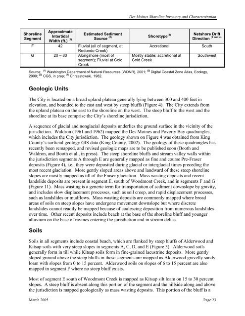
Shoreline<br />
Segment<br />
Approximate<br />
Intertidal<br />
Width (ft.) (1)<br />
F 42 Fluvial (all of segment, at<br />
Redondo Creek)<br />
G 20 – 80 Alongshore (most of<br />
segment); Fluvial at Cold<br />
Creek<br />
Estimated Sediment<br />
Netshore Drift<br />
(2) Shoretype(3)<br />
Source Direction<br />
Accretional<br />
Mostly stable; accretional at<br />
Cold Creek<br />
South<br />
(2 and 4)<br />
Southwest<br />
Source: (1) Washington Department of Natural Resources (WDNR), 2001; (2) Digital Coastal Zone Atlas, Ecology,<br />
2000; (3) CGS, in prep; (4) Chrzastowski, 1982.<br />
Geologic Units<br />
The City is located on a broad upland plateau generally lying between 300 and 400 feet in<br />
elevation, and bounded to the east and west by steep bluffs (Figure 4). The City extends from<br />
the upland plateau on the east to the shoreline on the west. The steep bluff to the west and the<br />
shoreline at its base comprise the City’s shoreline jurisdiction.<br />
A sequence of glacial and nonglacial deposits underlies the ground surface in the vicinity of the<br />
jurisdiction. Waldron (1961 and 1962) mapped the Des Moines and Poverty Bay quadrangles,<br />
which includes the City jurisdiction. The geology shown on Figure 4 was obtained from King<br />
County’s surficial geology GIS data (King County, 2002). The geology of these quadrangles has<br />
recently been remapped, and revised geologic maps are to be published soon (Booth and<br />
Waldron, and Booth et al., in press). The steep shoreline bluffs and stream valley walls within<br />
the jurisdiction segments A through E are generally mapped as fine and course Pre-Fraser<br />
deposits (Figure 4), i.e., they were deposited during glacial or interglacial times preceding the<br />
most recent glaciation. More gently sloped areas above and landward of these steep shoreline<br />
slopes are mostly mapped as till of the Fraser glaciation. Mass wasting deposits and recent<br />
landslide deposits are present in segment E, south of Woodmont Creek, and in segments F and G<br />
(Figure 11). Mass wasting is a generic term for transportation of sediment downslope by gravity,<br />
and includes slow displacement processes, such as soil creep, and rapid displacement processes,<br />
such as landslides or mudflows. Mass wasting deposits are commonly mapped where broad<br />
areas of soils on steep slopes have undergone movement downslope but where discrete<br />
landslides cannot readily be mapped because of coalescing deposition from numerous landslides<br />
over time. Other recent deposits include beach at the base of the shoreline bluff and younger<br />
alluvium on the base of ravines entering the jurisdiction and in stream deltas.<br />
Soils<br />
Soils in all segments include coastal beach, which are flanked by steep bluffs of Alderwood and<br />
Kitsap soils with very steep slopes in segments A, C, D, and E (Figure 3). Alderwood soils<br />
generally form in till while Kitsap soils form in fine-grained lacustrine deposits. More gently<br />
sloped ground above the steep bluffs in these segments are mapped as Alderwood gravelly sandy<br />
loam with slopes from 0 to 15 percent. Alderwood soils on slopes of 6 to 15 percent are also<br />
mapped in segment F where no steep bluff exists.<br />
Most of segment E south of Woodmont Creek is mapped as Kitsap silt loam on 15 to 30 percent<br />
slopes. A steep bluff is absent along this portion of the segment and the hillside along and above<br />
the jurisdiction is mapped geologically as mass wasting deposits. This portion of the bluff is a<br />
March 2005 Page 23
