

CITY OF DES MOINES SHORELINE MASTER PROGRAM
CITY OF DES MOINES SHORELINE MASTER PROGRAM
CITY OF DES MOINES SHORELINE MASTER PROGRAM

You also want an ePaper? Increase the reach of your titles
YUMPU automatically turns print PDFs into web optimized ePapers that Google loves.
Des Moines Shoreline Inventory and Characterization<br />
Shoreline Slope Stability<br />
The Department of Ecology Coastal Zone Atlas (Ecology, 1979) characterizes the slope stability<br />
of the entire shoreline along Puget Sound. Although the City does not regulate shoreline<br />
development based on slope stability characterization, the maps provide an additional source of<br />
documented landslide areas and stability. This mapping should not be considered<br />
comprehensive and does not include landslides that have occurred since the late 1970s.<br />
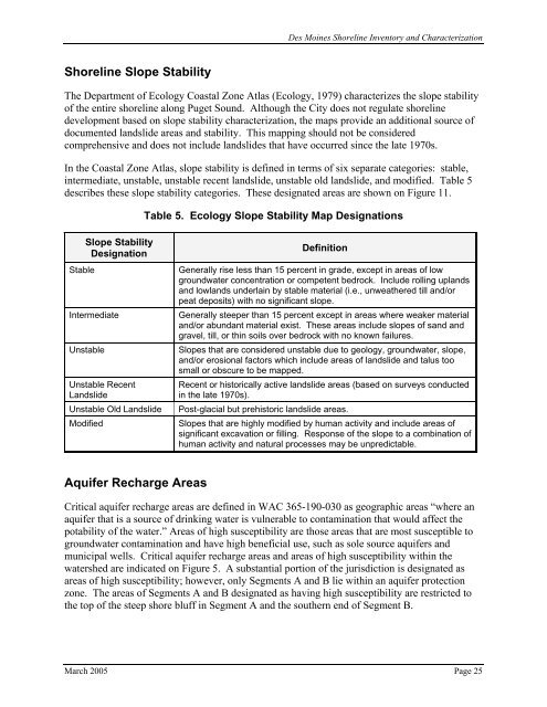
In the Coastal Zone Atlas, slope stability is defined in terms of six separate categories: stable,<br />
intermediate, unstable, unstable recent landslide, unstable old landslide, and modified. Table 5<br />
describes these slope stability categories. These designated areas are shown on Figure 11.<br />
Table 5. Ecology Slope Stability Map Designations<br />
Stable<br />
Slope Stability<br />
Designation<br />
Intermediate<br />
Unstable<br />
Unstable Recent<br />
Landslide<br />
Unstable Old Landslide<br />
Modified<br />
Definition<br />
Generally rise less than 15 percent in grade, except in areas of low<br />
groundwater concentration or competent bedrock. Include rolling uplands<br />
and lowlands underlain by stable material (i.e., unweathered till and/or<br />
peat deposits) with no significant slope.<br />
Generally steeper than 15 percent except in areas where weaker material<br />
and/or abundant material exist. These areas include slopes of sand and<br />
gravel, till, or thin soils over bedrock with no known failures.<br />
Slopes that are considered unstable due to geology, groundwater, slope,<br />
and/or erosional factors which include areas of landslide and talus too<br />
small or obscure to be mapped.<br />
Recent or historically active landslide areas (based on surveys conducted<br />
in the late 1970s).<br />
Post-glacial but prehistoric landslide areas.<br />
Slopes that are highly modified by human activity and include areas of<br />
significant excavation or filling. Response of the slope to a combination of<br />
human activity and natural processes may be unpredictable.<br />
Aquifer Recharge Areas<br />
Critical aquifer recharge areas are defined in WAC 365-190-030 as geographic areas “where an<br />
aquifer that is a source of drinking water is vulnerable to contamination that would affect the<br />
potability of the water.” Areas of high susceptibility are those areas that are most susceptible to<br />
groundwater contamination and have high beneficial use, such as sole source aquifers and<br />
municipal wells. Critical aquifer recharge areas and areas of high susceptibility within the<br />
watershed are indicated on Figure 5. A substantial portion of the jurisdiction is designated as<br />
areas of high susceptibility; however, only Segments A and B lie within an aquifer protection<br />
zone. The areas of Segments A and B designated as having high susceptibility are restricted to<br />
the top of the steep shore bluff in Segment A and the southern end of Segment B.<br />
March 2005 Page 25
