quakers_walk_planning_brief.pdf Quakers Walk ... - Wiltshire Council
quakers_walk_planning_brief.pdf Quakers Walk ... - Wiltshire Council
quakers_walk_planning_brief.pdf Quakers Walk ... - Wiltshire Council

You also want an ePaper? Increase the reach of your titles
YUMPU automatically turns print PDFs into web optimized ePapers that Google loves.
QUAKERS WALK, DEVIZES<br />
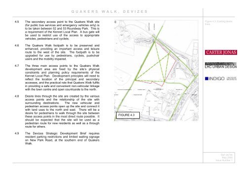
4.5 The secondary access point to the <strong>Quakers</strong> <strong>Walk</strong> site<br />
(for public bus services and emergency vehicles only) is<br />
to be taken between 52 and 53 Roundway Park. This is<br />
a requirement of the Kennet Local Plan. A bus gate will<br />
be used to restrict use of the access to appropriate<br />
vehicles, pedestrians and cyclists.<br />
Figure 4.3: Existing desire<br />
lines.<br />
4.6 The <strong>Quakers</strong> <strong>Walk</strong> footpath is to be preserved and<br />
enhanced, providing an important access and leisure<br />
route to the west of the site. The footpath is to be<br />
upgraded for use by pedestrians, cyclists, pushchair<br />
users and the mobility impaired.<br />
4.7 The three main access points to the <strong>Quakers</strong> <strong>Walk</strong><br />
development area are fixed by the site’s physical<br />
constraints and <strong>planning</strong> policy requirements of the<br />
Kennet Local Plan. Development principles will need to<br />
reflect the location of the principal and secondary<br />
accesses, and the practical role that <strong>Quakers</strong> <strong>Walk</strong> fulfils<br />
in providing a safe and convenient non-vehicular linkage<br />
with the town centre and open countryside to the north.<br />
4.8 Desire lines through the site are created by the various<br />
access points and the relationship of the site with<br />
surrounding destinations. The new vehicular and<br />
pedestrian access points open up the site and connect it<br />
with land uses to the north and east. There will be a<br />
desire for pedestrians to <strong>walk</strong> through the site between<br />
these access points in the most direct route possible. It<br />
should be expected that the site will be used as a<br />
pedestrian route for new residents as well as a through<br />
route for others.<br />
FIGURE 4.3<br />
4.9 The Devizes Strategic Development Brief requires<br />
resident parking restrictions and limited waiting signage<br />
on New Park Road, at the southern end of <strong>Quakers</strong><br />
<strong>Walk</strong>.<br />
Ref: 04744<br />
May 2005<br />
Issue Number 1