quakers_walk_planning_brief.pdf Quakers Walk ... - Wiltshire Council
quakers_walk_planning_brief.pdf Quakers Walk ... - Wiltshire Council
quakers_walk_planning_brief.pdf Quakers Walk ... - Wiltshire Council

You also want an ePaper? Increase the reach of your titles
YUMPU automatically turns print PDFs into web optimized ePapers that Google loves.
QUAKERS WALK, DEVIZES<br />
Boundary Treatments with Existing Development<br />
along Roundway Park and Parkfields<br />
4.18 The Kennet Local Plan requires that development<br />
proposals respect the amenity of adjacent land uses and<br />
residents along Roundway Park and Parkfields. There is<br />
no specific requirement for a landscape buffer, although<br />
feedback at the initial consultation events indicated an<br />
underlying aspiration among existing residents to distance<br />
themselves from their new neighbours.<br />
4.19 The proposed boundary treatment along Roundway Park<br />
and Parkfields is discussed in Section 5.0 of this Planning<br />
Brief.<br />
Helicopter Zone<br />
4.20 WSP Development prepared a Noise Assessment to<br />
inform discussions at the Local Plan Public Inquiry. This<br />
principally addressed noise issues associated with the use<br />
of the helipad, within the grounds of the Police<br />
Constabulary HQ.<br />
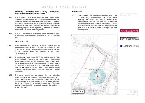
4.21 A building exclusion zone of 150 metres has been applied<br />
to the helipad. This includes a small area of land at the<br />
south eastern edge of the proposed development area.<br />
No new development of residential or school buildings will<br />
be possible in this area of land. Any new development<br />
near the exclusion zone will need to have regard to the<br />
potential disturbance arising from incoming and outgoing<br />
helicopters.<br />
4.22 The noise assessment concluded that no mitigation<br />
measures were considered necessary. However, as a<br />
design guide, residential properties located close to the<br />
helipad should be orientated such that, as far as possible,<br />
the angle of view to the helipad is minimised. This may<br />
include properties with gable-ends towards the helipad or<br />
angled obliquely.<br />
Flood issues<br />
4.23 The <strong>Quakers</strong> <strong>Walk</strong> site lies within Flood Risk Zone<br />
1 (low risk). Nonetheless, the Environment<br />
Agency has confirmed that a Flood Risk<br />
Assessment will be required for submission<br />
alongside the outline <strong>planning</strong> application. This is<br />
principally to address the potential impact on flood<br />
risk from the surface water drainage from the<br />
development.<br />
FIGURE 4.6<br />
Figure 4.6: Helipad Building<br />
Exclusion Zone<br />
Ref: 04744<br />
May 2005<br />
Issue Number 1