Phase 1B Underwater Archaeological Report for the Onondaga ...
Phase 1B Underwater Archaeological Report for the Onondaga ...
Phase 1B Underwater Archaeological Report for the Onondaga ...
You also want an ePaper? Increase the reach of your titles
YUMPU automatically turns print PDFs into web optimized ePapers that Google loves.
FINAL<br />
<strong>Phase</strong> IB <strong>Underwater</strong> <strong>Archaeological</strong> Resources <strong>Report</strong> <strong>for</strong> <strong>Onondaga</strong> Lake Superfund Site<br />
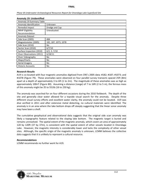
Anomaly 19: Unidentified<br />
Anomaly 19 Summary Table<br />
Anomaly Identification Unknown<br />
Remedial Impact<br />
Dredge and Cap<br />
NRHP Eligibility<br />
Unevaluated<br />
Recommendation<br />
Anomaly Dataset<br />
Side Scan (2005) 484<br />
Magnetometer (2005) 182, 187, 1073, 1078<br />
Side Scan (2010)<br />
No<br />
Sector Scan (2010) 6/7/10<br />
Surface Inspection (2010) 6/2, 3, 7/10<br />
Diver Observations (2011) 6/28/11<br />
Diver Videography<br />
No<br />
Maps/Charts<br />
No<br />
Aerial Imagery<br />
No<br />
Historic Accounts<br />
No<br />
Research Results<br />
A19 is co-located with four magnetic anomalies digitized from CRE’s 2005 data: #182; #187; #1073; and<br />
#1078 (Figure 79). These anomalies were observed on four parallel survey transects spaced 25ft (8m)<br />
apart at a depth of approximately 3 to 6ft (1 to 2m). The magnitude of <strong>the</strong>se anomalies was as high as<br />
approximately 100nT (Figure 80). Assuming a distance (range) of 7 to 16ft (2 to 5 m), <strong>the</strong> ferrous mass<br />
of this anomaly might be 35 to 551lb (16 to 250 kg).<br />
The anomaly was searched <strong>for</strong> on four different occasions during <strong>the</strong> 2010 fieldwork. The depth of <strong>the</strong><br />
site and generally clear water allowed <strong>for</strong> a topside visual search <strong>for</strong> <strong>the</strong> anomaly. Despite three<br />
different visual survey ef<strong>for</strong>ts and excellent water clarity, <strong>the</strong> anomaly could not be located. A19 was<br />
dive verified in 2011 and after extensive metal detecting, no cultural materials were identified. The<br />
anomaly is in an area where <strong>the</strong> lake bottom drops off steeply suggesting that <strong>the</strong> linear sonar anomaly<br />
may have been a shelf.<br />
The cumulative geophysical and observational data suggests that <strong>the</strong> original side scan anomaly was<br />
likely a topographic feature related to <strong>the</strong> sloping lake bottom. The magnetic target is buried and<br />
remains unresolved. The spatial extent of <strong>the</strong> magnetic anomaly, which covers an area of approximately<br />
120 by 120ft (37 by 37m), is consistent with <strong>the</strong> spatial extent of o<strong>the</strong>r vessels located in <strong>Onondaga</strong><br />
Lake. However, <strong>the</strong> magnetic intensity is considerably lower and lacks <strong>the</strong> complexity of o<strong>the</strong>r vessel<br />
sites. Although, <strong>the</strong> specific origin of <strong>the</strong> magnetic anomaly is unknown, LCMM believes <strong>the</strong> collective<br />
data suggests that it is unlikely to represent a cultural resource.<br />
Recommendations<br />
LCMM recommends no fur<strong>the</strong>r work <strong>for</strong> A19.<br />
112


