Environmental Impact Assessment(EIA) Registration for the ...
Environmental Impact Assessment(EIA) Registration for the ...
Environmental Impact Assessment(EIA) Registration for the ...
You also want an ePaper? Increase the reach of your titles
YUMPU automatically turns print PDFs into web optimized ePapers that Google loves.
REVISED PROJECT DESCRIPTION AND ENVIRONMENTAL IMPACT ASSESSMENT (<strong>EIA</strong>) REGISTRATION<br />
FOR THE NEPISIGUIT FALLS GENERATING STATION MODIFICATION AND REHABILITATION PROJECT<br />
• implement proper storage, handling, use, and disposal procedures <strong>for</strong> any hazardous<br />
materials; and<br />
• comply with all provincial and federal legislation, permits, approvals and guidelines.<br />
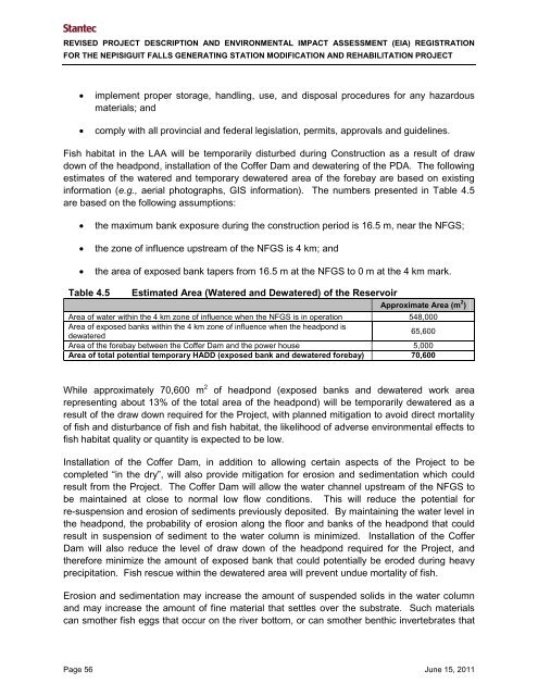
Fish habitat in <strong>the</strong> LAA will be temporarily disturbed during Construction as a result of draw<br />
down of <strong>the</strong> headpond, installation of <strong>the</strong> Coffer Dam and dewatering of <strong>the</strong> PDA. The following<br />
estimates of <strong>the</strong> watered and temporary dewatered area of <strong>the</strong> <strong>for</strong>ebay are based on existing<br />
in<strong>for</strong>mation (e.g., aerial photographs, GIS in<strong>for</strong>mation). The numbers presented in Table 4.5<br />
are based on <strong>the</strong> following assumptions:<br />
• <strong>the</strong> maximum bank exposure during <strong>the</strong> construction period is 16.5 m, near <strong>the</strong> NFGS;<br />
• <strong>the</strong> zone of influence upstream of <strong>the</strong> NFGS is 4 km; and<br />
• <strong>the</strong> area of exposed bank tapers from 16.5 m at <strong>the</strong> NFGS to 0 m at <strong>the</strong> 4 km mark.<br />
Table 4.5<br />
Estimated Area (Watered and Dewatered) of <strong>the</strong> Reservoir<br />
Approximate Area (m 2 )<br />
Area of water within <strong>the</strong> 4 km zone of influence when <strong>the</strong> NFGS is in operation 548,000<br />
Area of exposed banks within <strong>the</strong> 4 km zone of influence when <strong>the</strong> headpond is<br />
dewatered<br />
65,600<br />
Area of <strong>the</strong> <strong>for</strong>ebay between <strong>the</strong> Coffer Dam and <strong>the</strong> power house 5,000<br />
Area of total potential temporary HADD (exposed bank and dewatered <strong>for</strong>ebay) 70,600<br />
While approximately 70,600 m 2 of headpond (exposed banks and dewatered work area<br />
representing about 13% of <strong>the</strong> total area of <strong>the</strong> headpond) will be temporarily dewatered as a<br />
result of <strong>the</strong> draw down required <strong>for</strong> <strong>the</strong> Project, with planned mitigation to avoid direct mortality<br />
of fish and disturbance of fish and fish habitat, <strong>the</strong> likelihood of adverse environmental effects to<br />
fish habitat quality or quantity is expected to be low.<br />
Installation of <strong>the</strong> Coffer Dam, in addition to allowing certain aspects of <strong>the</strong> Project to be<br />
completed “in <strong>the</strong> dry”, will also provide mitigation <strong>for</strong> erosion and sedimentation which could<br />
result from <strong>the</strong> Project. The Coffer Dam will allow <strong>the</strong> water channel upstream of <strong>the</strong> NFGS to<br />
be maintained at close to normal low flow conditions. This will reduce <strong>the</strong> potential <strong>for</strong><br />
re-suspension and erosion of sediments previously deposited. By maintaining <strong>the</strong> water level in<br />
<strong>the</strong> headpond, <strong>the</strong> probability of erosion along <strong>the</strong> floor and banks of <strong>the</strong> headpond that could<br />
result in suspension of sediment to <strong>the</strong> water column is minimized. Installation of <strong>the</strong> Coffer<br />
Dam will also reduce <strong>the</strong> level of draw down of <strong>the</strong> headpond required <strong>for</strong> <strong>the</strong> Project, and<br />
<strong>the</strong>re<strong>for</strong>e minimize <strong>the</strong> amount of exposed bank that could potentially be eroded during heavy<br />
precipitation. Fish rescue within <strong>the</strong> dewatered area will prevent undue mortality of fish.<br />
Erosion and sedimentation may increase <strong>the</strong> amount of suspended solids in <strong>the</strong> water column<br />
and may increase <strong>the</strong> amount of fine material that settles over <strong>the</strong> substrate. Such materials<br />
can smo<strong>the</strong>r fish eggs that occur on <strong>the</strong> river bottom, or can smo<strong>the</strong>r benthic invertebrates that<br />
Page 56 June 15, 2011


