the PDF version! - Danube Limes
the PDF version! - Danube Limes
the PDF version! - Danube Limes

Create successful ePaper yourself
Turn your PDF publications into a flip-book with our unique Google optimized e-Paper software.
Frontiers of <strong>the</strong> Roman Empire – Ripa Pannonica in Hungary (RPH) Nomination statement<br />
Hungarian limes research owes a great deal to German and English travel sketches and travel diaries from<br />
<strong>the</strong> 16 th to 18 th centuries. The limes road – or at least its path – preserved its significance during <strong>the</strong> Middle<br />
Ages and later as <strong>the</strong> most important overland artery between Europe and Asia Minor. From <strong>the</strong> former<br />
descriptions and sketches of varying accuracy it appears that at that time one was able to observe standing<br />
walls and clearly outlined systems of ditches in many places, which later unfortunately fell victim to stone<br />
quarrying and intensive agricultural cultivation for <strong>the</strong> most part. The descriptions that are <strong>the</strong> best and<br />
preserve <strong>the</strong> most archeological data originated from <strong>the</strong> pens of Johannes Beza, Hans Dernschwam,<br />
Eduard Brown, Richard Pococke and Jeremias Milles.<br />
Since it seems that L. Marsigli was not familiar with <strong>the</strong> work of W. Lazius, R. Pococke believed that he<br />
was <strong>the</strong> first to recognize <strong>the</strong> remains of Brigetio next to Szőny, “It has been commonly thought that Bregetio<br />
was at Gran, but in considering <strong>the</strong> distances, and from <strong>the</strong> inscriptions found at Zeny a leage below Comorra,<br />
we discovered that this was <strong>the</strong> site of Bregetio” (Pococke II/2, 245. = Kubitschek 1929, 40).<br />
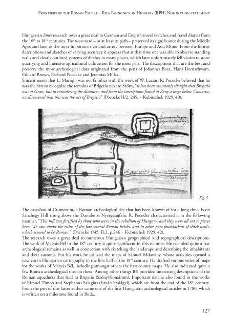
Fig. 5<br />
The castellum of Crumerum, a Roman archeological site that has been known of for a long time, is on<br />
Sánchegy Hill rising above <strong>the</strong> <strong>Danube</strong> at Nyergesújfalu. R. Pococke characterized it in <strong>the</strong> following<br />
manner, “This hill was fortified by those who were in <strong>the</strong> rebellion of Hungary, and <strong>the</strong>y were all cut to pieces<br />
here. We saw about <strong>the</strong> ruins of <strong>the</strong> fort several Roman bricks, and in o<strong>the</strong>r part foundations of thick walls,<br />
which seemed to be Roman.” (Pococke 1745, II,2, p.246 = Kubitschek 1929, 42).<br />
The research owes a great deal to numerous Hungarian geographical and topographical descriptions.<br />
The work of Mátyás Bél in <strong>the</strong> 18 th century is quite significant in this manner. He recorded quite a few<br />
archeological remains as well in connection with sketching <strong>the</strong> landscape and describing <strong>the</strong> inhabitants<br />
and <strong>the</strong>ir customs. For his work he utilized <strong>the</strong> maps of Sámuel Mikoviny, whose activities opened a<br />
new era in Hungarian cartography in <strong>the</strong> first half of <strong>the</strong> 18 th century. He drafted various series of maps<br />
for <strong>the</strong> works of Mátyás Bél, including amongst o<strong>the</strong>rs <strong>the</strong> first county maps. He also indicated quite a<br />
few Roman archeological sites on <strong>the</strong>se. Among o<strong>the</strong>r things Bél provided interesting descriptions of <strong>the</strong><br />
Roman aqueducts that lead to Brigetio (Szőny/Komárom). Important data is also found in <strong>the</strong> works<br />
of Sámuel Timon and Stephanus Salagius (István Szalágyi), which are from <strong>the</strong> end of <strong>the</strong> 18 th century.<br />
From <strong>the</strong> pen of this latter author came one of <strong>the</strong> first Hungarian archeological articles in 1780, which<br />
is written on a milestone found in Buda.<br />
127