the PDF version! - Danube Limes
the PDF version! - Danube Limes
the PDF version! - Danube Limes

Create successful ePaper yourself
Turn your PDF publications into a flip-book with our unique Google optimized e-Paper software.
Frontiers of <strong>the</strong> Roman Empire – Ripa Pannonica in Hungary (RPH) Nomination statement<br />
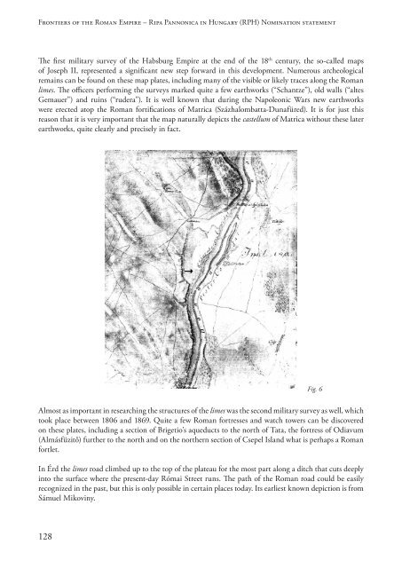
The first military survey of <strong>the</strong> Habsburg Empire at <strong>the</strong> end of <strong>the</strong> 18 th century, <strong>the</strong> so-called maps<br />
of Joseph II, represented a significant new step forward in this development. Numerous archeological<br />
remains can be found on <strong>the</strong>se map plates, including many of <strong>the</strong> visible or likely traces along <strong>the</strong> Roman<br />
limes. The officers performing <strong>the</strong> surveys marked quite a few earthworks (“Schantze”), old walls (“altes<br />
Gemauer”) and ruins (“rudera”). It is well known that during <strong>the</strong> Napoleonic Wars new earthworks<br />
were erected atop <strong>the</strong> Roman fortifications of Matrica (Százhalombatta-Dunafüred). It is for just this<br />
reason that it is very important that <strong>the</strong> map naturally depicts <strong>the</strong> castellum of Matrica without <strong>the</strong>se later<br />
earthworks, quite clearly and precisely in fact.<br />
Fig. 6<br />
Almost as important in researching <strong>the</strong> structures of <strong>the</strong> limes was <strong>the</strong> second military survey as well, which<br />
took place between 1806 and 1869. Quite a few Roman fortresses and watch towers can be discovered<br />
on <strong>the</strong>se plates, including a section of Brigetio’s aqueducts to <strong>the</strong> north of Tata, <strong>the</strong> fortress of Odiavum<br />
(Almásfüzitő) fur<strong>the</strong>r to <strong>the</strong> north and on <strong>the</strong> nor<strong>the</strong>rn section of Csepel Island what is perhaps a Roman<br />
fortlet.<br />
In Érd <strong>the</strong> limes road climbed up to <strong>the</strong> top of <strong>the</strong> plateau for <strong>the</strong> most part along a ditch that cuts deeply<br />
into <strong>the</strong> surface where <strong>the</strong> present-day Római Street runs. The path of <strong>the</strong> Roman road could be easily<br />
recognized in <strong>the</strong> past, but this is only possible in certain places today. Its earliest known depiction is from<br />
Sámuel Mikoviny.<br />
128