the PDF version! - Danube Limes
the PDF version! - Danube Limes
the PDF version! - Danube Limes

Create successful ePaper yourself
Turn your PDF publications into a flip-book with our unique Google optimized e-Paper software.
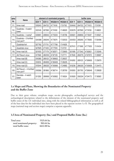
Frontiers of <strong>the</strong> Roman Empire – Ripa Pannonica in Hungary (RPH) Nomination statement<br />
RPH<br />
Nr.<br />
Name<br />
element of nominated property<br />
buffer zone<br />
EOV Y EOV X WGS84 N WGS84 E EOV Y EOV X WGS84 N WGS84 E<br />
111. limes road 535243 264722 47.71618 17.51792 534942 264722 47.71613 17.51391<br />
112.<br />
Quadrata – 5 watch<br />
tower<br />
533145 267590 47.74160 17.48920 533078 267590 47.74159 17.48831<br />
113. Quadrata – I camp? 530801 268942 47.75333 17.45758 530621 268850 47.75247 17.45521<br />
114.<br />
115.<br />
Quadrata – 2 fortified<br />
river port?<br />
534388 269249 47.75674 17.50533 534353 269260 47.75683 17.50486<br />
Quadrata fort 527762 271710 47.77766 17.41629<br />
Quadrata vicus 527825 271433 47.77518 17.41721<br />
527613 271568 47.77635 17.41434<br />
116. limes road (A) 521933 277179 47.82571 17.33693 521595 277242 47.82621 17.33240<br />
117. Ad Flexum vicus 517569 282335 47.87120 17.27711 517849 282275 47.87072 17.28087<br />
118.<br />
limes road (B) 516380 285123 47.89602 17.26037<br />
limes road (C) 516516 284905 47.89409 17.26225<br />
516262 285123 47.89600 17.25879<br />
119. limes road (D) 515544 286325 47.90666 17.24882 515238 286325 47.90659 17.24473<br />
120.<br />
121.<br />
Ad Flexum – 4 fortified<br />
river port?<br />
Gerulata – 4 watch<br />
tower<br />
518366 281866 47.86714 17.28790 518393 281793 47.86649 17.28828<br />
511250 289969 47.93852 17.19024 510929 290334 47.94173 17.18583<br />
1.e Maps and Plans, Showing <strong>the</strong> Boundaries of <strong>the</strong> Nominated Property<br />
and <strong>the</strong> Buffer Zone<br />
Due to <strong>the</strong>ir great volume, ortophoto maps, on-site photographs, archaeological surveys and <strong>the</strong><br />
archaeological descriptions related to <strong>the</strong> delimitation of <strong>the</strong> element of <strong>the</strong> nominated property and<br />
buffer zones of <strong>the</strong> 121 individual sites, along with <strong>the</strong> related bibliographical information as well as all<br />
of <strong>the</strong> base data for <strong>the</strong> individual sites have been placed in <strong>the</strong> separate section 1.e II. The geographical<br />
maps (national map and section maps) comprise a separate appendix.<br />
1.f Area of Nominated Property (ha.) and Proposed Buffer Zone (ha.)<br />
Total area:<br />
total nominated property:<br />
total buffer zone:<br />
5525.64 ha<br />
903.64 ha<br />
4622.00 ha<br />
21