

The Ecology of Hydric Hammocks - USGS National Wetlands ...
The Ecology of Hydric Hammocks - USGS National Wetlands ...
The Ecology of Hydric Hammocks - USGS National Wetlands ...

You also want an ePaper? Increase the reach of your titles
YUMPU automatically turns print PDFs into web optimized ePapers that Google loves.
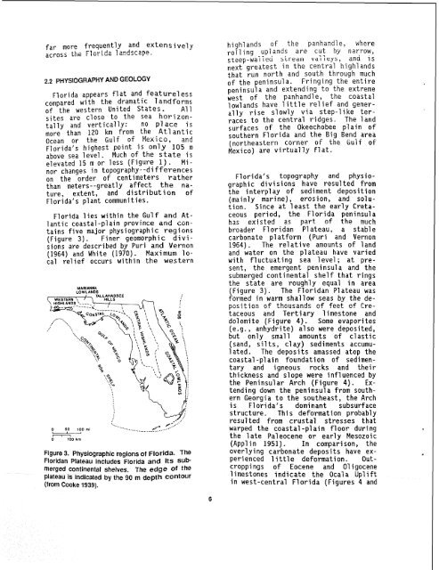
far more frequently and extensivelyacross the Florida 1 andscape.2.2 PHYSIOGRAPHY AND GEOLOGYFlorida appears flat and featurelesscompared with the dramatic 1 andforms<strong>of</strong> the western United States. Allsites are close to the sea horizontallyand vertically: no place ismore than 120 km from the At1 anticOcean or the Gulf <strong>of</strong> Mexico, andFlorida's highest point is only 105 mabove sea level. Much <strong>of</strong> the state iselevated 15 m or less (Figure 1). Minorchanges in topography--di fferenceson the order <strong>of</strong> centimeters ratherthan meters--greatly affect the nature,extent, and distribution <strong>of</strong>Florida's plant communities.Florida lies within the Gulf and Atlanticcoastal-plain province and containsfive major physiographic regions(Figure 3). Finer geomorphic divisionsare described by Puri and Vernon(1964) and White (1970). Maximum localre1 ief occurs within the westernMARIANNALOWLANDSFigure 3. Physiographic regions <strong>of</strong> Florida. <strong>The</strong>Floridan Plateau includes Florida and its submergedcontinental shelves. <strong>The</strong> edge <strong>of</strong> theplateau is indicated by the go m depth contour(from Cooke 1939).highl ands <strong>of</strong> the panhandle, whererolling uplands are cut by narrow,steep-wai i eu biftjd~u vdi 7 ey~, and 1 snext greatest in the central highl andsthat run north and south through much<strong>of</strong> the peninsula. Fringing the entirepeninsula and extending to the extremewest <strong>of</strong> the panhandle, the coastallow1 ands have 1 i ttl e re1 i ef and generallyrise slowly via step-like terracesto the central ridges. <strong>The</strong> landsurfaces <strong>of</strong> the Okeechobee plain <strong>of</strong>southern Florida and the Big Bend area(northeastern corner <strong>of</strong> .ehe Gulf <strong>of</strong>Mexico) are virtually flat.Florida's topography and physiographicdivisions have resulted fromthe interplay <strong>of</strong> sediment deposition(mainly marine), erosion, and solution.Since at least the early Cretaceousperiod, the Florida peninsulahas existed as part <strong>of</strong> the muchbroader Floridan Pl ateau, a stablecarbonate platform (Puri and Vernon1964). <strong>The</strong> relative amounts <strong>of</strong> landand water on the plateau have variedwith fluctuating sea level; at present,the emergent peninsula and thesubmerged continental she1 f that ringsthe state are roughly equal in area(Figure 3). <strong>The</strong> Floridan Plateau wasformed in warm shallow seas by the deposition<strong>of</strong> thousands <strong>of</strong> feet <strong>of</strong> Cretaceousand Tertiary limestone anddo1 omi te (Figure 4). Some evapori tes(e.g., anhydri te) a1 so were deposited,but only small amounts <strong>of</strong> clastic(sand, silts, clay) sediments accumulated.<strong>The</strong> deposits amassed atop thecoastal-plain foundation <strong>of</strong> sedimentaryand igneous rocks and theirthickness and slope were influenced bythe Peninsular Arch (Figure 4). Extendingdown the peninsula from southernGeorgia to the southeast, the Archis Florida's dominant subsurfacestructure. This deformation probablyresulted from crustal stresses thatwarped the coastal -plain floor duringthe 1 ate Paleocene or early Mesozoic(Applin 1951). In comparison, theoverlying carbonate deposits have experienced1 ittle deformation. Outcroppings <strong>of</strong> Eocene and 01 igocene1 imestones indicate the Ocal a Up1 i ftin west-central Florida (Figures 4 ands


