

Land Use 2025 - RhodeMap RI
Land Use 2025 - RhodeMap RI
Land Use 2025 - RhodeMap RI
- No tags were found...

Create successful ePaper yourself
Turn your PDF publications into a flip-book with our unique Google optimized e-Paper software.
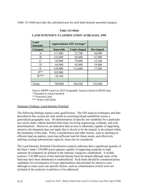
Table 121-04(6) provides the calculated area for each land intensity potential category.Table 121-04(6)LAND INTENSITY CLASSIFICATION ACREAGES, 1995<strong>Land</strong>IntensityApproximate GIS Acreage*Category Statewide Undeveloped DevelopedA 117,800 22,700 94,900B 132,600 85,600 47,000C 94,900 79,800 15,100D 64,900 45,800 19,400E 129,800 112,600 17,200P** 102,000W*** 58,100Totals 700,000 346,500 193,600Source: <strong>RI</strong>SPP <strong>Land</strong> <strong>Use</strong> <strong>2025</strong> Geographic Analysis based on <strong>RI</strong>GIS data.* Rounded to nearest hundred** Protected <strong>Land</strong>*** Water with bufferSummary Findings: <strong>Land</strong> Intensity PotentialThe following findings require some qualification. The GIS analysis techniques and datadescribed in this section are only useful in examining broad suitabilities across ageneralized geographic area. No determination of specific site suitability for a particularuse can be made without detailed field study involving engineering, wetlands, and soilsdeterminations. Moreover, an indication that an area is inherently capable of supportingintensive development does not imply that it should so be developed, or developed withinthe timeframe of this plan. Policy considerations and other factors, such as attaining anefficient land use pattern, reserving sufficient land for future needs, and effectivelyutilizing existing infrastructure capacity, must also be considered.The <strong>Land</strong> Intensity Potential Classification analysis indicates that a significant quantity ofthe State’s land (~250,000 acres) appears capable of supporting moderate to highintensity development (as defined in the intensity categories established). A sizableportion (~142,000 acres) of this land had already been developed although some of theland may have been abandoned or underutilized. Such lands should be considered primecandidates for investigation of reuse opportunities and potential for intensive uses –although in some cases site-specific factors, such as contamination (which were notincluded in the analysis) would have to be addressed.4-12<strong>Land</strong> <strong>Use</strong> <strong>2025</strong>: Rhode Island State <strong>Land</strong> <strong>Use</strong> Policies and Plan (April 2006)


