

Land Use 2025 - RhodeMap RI
Land Use 2025 - RhodeMap RI
Land Use 2025 - RhodeMap RI
- No tags were found...

Create successful ePaper yourself
Turn your PDF publications into a flip-book with our unique Google optimized e-Paper software.
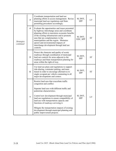
3Coordinate transportation and land useplanning efforts in access management. Revisemunicipal land use regulations and Statepermitting procedures accordingly.M, DOT,SPPLTStrategiescontinued4 Evaluate the opportunities and issues presentedby highway interchange areas and coordinateplanning efforts to maximize economic benefitsof the existing infrastructure and to promoteuses that are complementary to themunicipalities and the region. Minimizesprawl and environmental impacts ofinterchange development through land usecontrols.M, DOT,EDC, SPPST5Protect the character and quality of scenicroadways through coordination of municipalland use controls for areas adjacent to theroadways and State transportation planning forareas within the right-of-way.M, DOT,SPPST6<strong>Use</strong> land use plans and regulations to supportride-sharing, commuter parking, and masstransit in order to encourage alternatives tosingle occupant per vehicle commuting in allmajor developments and centers.M, DOT,SPPSTRestrict land uses that exacerbate trafficcongestion and conflict.Separate land uses with different traffic andpedestrian characteristics.7Control new development through municipalland use regulations to ensure compatibility ofland use with transportation capacity andfunctions of roadways servicing it.M, DOT,SPPLTMitigate the transportation impacts of existingdevelopment through municipal planning andpublic improvement projects.5-18<strong>Land</strong> <strong>Use</strong> <strong>2025</strong>: Rhode Island State <strong>Land</strong> <strong>Use</strong> Policies and Plan (April 2006)


