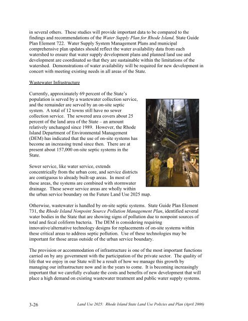
in several others. These studies will provide important data to be compared to thefindings and recommendations of the Water Supply Plan for Rhode Island, State GuidePlan Element 722. Water Supply System Management Plans and municipalcomprehensive plan updates should reflect the water availability data from eachwatershed to ensure that water supply development plans and planned land use anddevelopment are coordinated so that they are sustainable within the limitations of thewatershed. Demonstrations of water availability will be required for new development inconcert with meeting existing needs in all areas of the State.Wastewater InfrastructureCurrently, approximately 69 percent of the State’spopulation is served by a wastewater collection service,and the remainder are served by an on-site septicsystem. A total of 12 towns still have no sewercollection service. The sewered area covers about 25percent of the land area of the State – an amountrelatively unchanged since 1989. However, the RhodeIsland Department of Environmental Management(DEM) has indicated that the use of on-site systems hasbecome an increasing trend since then. There are atpresent about 157,000 on-site septic systems in theState.Sewer service, like water service, extendsconcentrically from the urban core, and service districtsare contiguous to already built-up areas. In most ofthese areas, the systems are combined with stormwaterdrainage. These sewer service areas are wholly withinthe urban service boundary on the Future <strong>Land</strong> <strong>Use</strong> <strong>2025</strong> map.Otherwise, wastewater is handled by on-site septic systems. State Guide Plan Element731, the Rhode Island Nonpoint Source Pollution Management Plan, identified severalwater bodies in the State that are showing signs of pollution due to nonpoint sources oftotal and fecal coliform bacteria. The DEM is considering requiringinnovative/alternative technology designs for replacements of on-site systems withinthese critical areas to address septic pollution. <strong>Use</strong> of these technologies may beimportant for those areas outside of the urban service boundary.The provision or accommodation of infrastructure is one of the most important functionscarried on by any government with the participation of the private sector. The quality oflife that we enjoy in our State will be a result of how we manage this growth bymanaging our infrastructure now and in the years to come. It is becoming increasinglyimportant that we carefully evaluate the costs and benefits of new development that willplace a high demand on existing wastewater treatment and public water supply systems.3-26<strong>Land</strong> <strong>Use</strong> <strong>2025</strong>: Rhode Island State <strong>Land</strong> <strong>Use</strong> Policies and Plan (April 2006)
3-6 Open Space and RecreationThe term “open space” is unfortunately vague. Does it refer to land that has beenprotected, or land that just hasn’t been developed – yet? Focus groups conducted byPublic Opinion Strategies in 2004 found that the public perceived open space “as emptyland, not near them," and did not necessarily see how they benefited from it or could useit.The Rhode Island Comprehensive Planning and <strong>Land</strong> <strong>Use</strong> Act defines open space as:Any parcel or area of land or water set aside for public or private use orenjoyment or for the use and enjoyment of owners and occupants of landadjoining or neighboring such open space; provided that the area may beimproved with only those buildings, structures, streets, and off-streetparking, and other improvements that are designed to be incidental to thenatural openness of the land.By this definition, open space may be either permanently protected or subject toconversion (e.g., private golf courses, land enrolled in the Farm, Forest, and Open SpaceProgram, etc.). Both in preceding chapters and in subsequent chapters, we use the term“greenspace” to distinguish those lands that are permanently protected fromdevelopment.In this plan, “recreation” space refers to open space that has been dedicated torecreational purposes. <strong>Land</strong> committed to recreation may mean development for “active”recreation, which includes constructed facilities such as sports fields, playgrounds, golfcourses, swimming pools and tennis courts. A second type of recreational use, “passive”recreation, involves existing natural resources and can be engaged in at sites that areundeveloped or minimally developed. Examples include hiking, horseback riding, crosscountryskiing, swimming atbeaches, fishing, canoeing, andbicycling.Open space can be for nonrecreationaluses too. Farmland isgenerally referred to as open space.<strong>Land</strong> surrounding public drinkingwater supplies such as the ScituateReservoir is protected fromdevelopment, but even passiverecreation is prohibited.Another category of open space is land owned by private conservation groups, such asthe Audubon Society of Rhode Island and the Nature Conservancy. While much of theseconservation areas are available for passive recreation, some lands are reserved forwildlife and habitat preservation and are closed to the public. Even these “restricted”<strong>Land</strong> <strong>Use</strong> <strong>2025</strong>: Rhode Island State <strong>Land</strong> <strong>Use</strong> Policies and Plan (April 2006)3-27
- Page 2:
The Statewide Planning Program, Rho
- Page 5:
Advisors to the Technical Committee
- Page 8 and 9:
objectives is the only way we can p
- Page 10:
In addition, there are four technic
- Page 13 and 14:
Institutional .....................
- Page 15:
LIST OF TABLESTable 121-03(1) Perce
- Page 19 and 20:
PART ONE: WHERE ARE WE AND WHERE AR
- Page 21 and 22:
distinction between historic urban
- Page 23 and 24:
constructed on larger lots than in
- Page 25 and 26:
major pubic investments, such as re
- Page 27 and 28:
and also included a continuation of
- Page 30 and 31:
Geographically, the Current Trend S
- Page 33: PART TWOWHERE DO WE WANT TO BE IN 2
- Page 36 and 37: Gauging Public Perceptions of Land
- Page 38 and 39: etween the historic urban centers a
- Page 40 and 41: to provide guidance for the (vast m
- Page 42 and 43: LUO 4C: Utilize infrastructure to a
- Page 44 and 45: LUP 12: Encourage development patte
- Page 46 and 47: commercial, and institutional devel
- Page 48 and 49: comprehensive plans and supporting
- Page 50 and 51: Urban Services BoundaryAs noted pre
- Page 52 and 53: Conservation/open space-style devel
- Page 54 and 55: Narragansett Indian Tribal LandsThi
- Page 57 and 58: PART THREE: WHAT ISSUES DO WE NEED
- Page 59 and 60: need of replacement), expanded faci
- Page 61 and 62: • wastewater system design and ca
- Page 63 and 64: • Less than five percent of Rhode
- Page 65 and 66: To help address its housing needs,
- Page 67 and 68: - needs to be upgraded, the advanta
- Page 69 and 70: How This Land Use Plan Supports Sta
- Page 71 and 72: industry has resulted. Since the 19
- Page 73 and 74: municipal plans as future commercia
- Page 75 and 76: The Future Land Use 2025 map identi
- Page 77 and 78: modifications, the capacity of floo
- Page 79 and 80: Restoration and maintenance of the
- Page 81: The best locations for redevelopmen
- Page 85 and 86: • How much land overall should be
- Page 87 and 88: Providence to Warwick and Wickford,
- Page 89 and 90: Another disincentive to walking and
- Page 91: Designers and the community at larg
- Page 95 and 96: PART FOUR: HOW DO WE GET THERE?4-1
- Page 97 and 98: density or medium-high density deve
- Page 99 and 100: Table 121-04(2)COMPOSITE OF FUTURE
- Page 101 and 102: This section describes the process
- Page 103 and 104: wetlands comprised about 18 percent
- Page 105 and 106: Table 121-04(5) defines the five la
- Page 107 and 108: For undeveloped areas, the analysis
- Page 109 and 110: 4-8 Scenario Analysis: Assessing Al
- Page 111 and 112: A major variable in distinguishing
- Page 113 and 114: The land need projections for the f
- Page 115 and 116: Land Use 2025: Rhode Island State L
- Page 117 and 118: Land Use 2025: Rhode Island State L
- Page 119 and 120: Table 121-04(10)QUANTITATIVE* COMPA
- Page 121 and 122: The concentration of development in
- Page 123 and 124: 4-10 Scenario SelectionIn August 20
- Page 125 and 126: Table 121-04(12)COMPARISON OF COMPO
- Page 127: PART FIVEWHAT MUST BE DONE TOACHIEV
- Page 130 and 131: 5-2 State InvestmentsAs noted in Pa
- Page 132 and 133:
land use plan must contain an analy
- Page 134 and 135:
Table 121-05(1)GOALS, OBJECTIVES, A
- Page 136 and 137:
Strategies12Support the participati
- Page 138 and 139:
Community DesignLeadAgenciesTimeFra
- Page 140 and 141:
7Locate small-scale convenience sho
- Page 142 and 143:
InfrastructureLeadAgenciesTimeFrame
- Page 144 and 145:
4Limit the proliferation of treatme
- Page 146 and 147:
3Coordinate transportation and land
- Page 148 and 149:
3Promote establishment of electroni
- Page 150 and 151:
AbbreviationCRMCDEMDOADOHDOTEDCGAGO
- Page 152 and 153:
Source Management Plan, State Guide
- Page 154:
41. Office of Federal Housing Enter