The Shoreline RegionThe power of place is nowhere more evident than in Rhode Island’s shoreline region.Many Rhode Islanders have strong emotional connections to communities and attractionsalong the State’s coast, special places that have been important parts of their lives.Tourists from out of State are drawn every year to the area. Many of the fabled“cottages” of Newport of the late 19th and early 20th centuries were built by the rich andfamous of New York. Block Island iscalled “the Bermuda of the North.”Little Compton has the charm of oldCape Cod without the traffic.Rhode Island’s shoreline isremarkably diverse, including criticalnatural habitat, public and privatebeaches, summer colonies, historicvillages, seaside estates, marinas andpiers, and miles of rivers. But it alsois a working shoreline, with Quonsetand Davisville, oil tank farms,shipyards, naval installations, and major commercial fishing ports. Whether involved inmaritime commerce, tourism, recreation, energy supply, military activities, ormaintaining an ecosystem, coastal areas are an essential part of the history and future ofRhode Island.<strong>Land</strong> development pressures in coastal areas have been steadily increasing for decades.Coastal communities must determine how best to protect the most fragile and valuablenatural resources along their shores, avoid encroachment on working ports, providegenerous opportunities for public access and recreation, and direct development awayfrom areas subject to erosion and flooding from gale-force winds, storm surge, and sealevel rise.<strong>Land</strong> use controls are particularly important in the shoreline region. Strategies forresolving conflicts between competing uses must be in place. Local officials mustrecognize that new structures, poorly sited, may be extremely vulnerable to severeweather. Open space landward of sensitive features should be protected as a buffer tostorm damage and erosion. Hazard mitigation plans should be developed to deal withpotential problems before they become emergencies.Transportation and Economic DevelopmentThe Interstate highway system and its interchanges created a series of new sites withexcellent potential for commercial and industrial development – large tracts ofundeveloped land with easy access to high volumes of traffic. This continues to be anattraction to this type of development. While much of this land has been identified in3-16<strong>Land</strong> <strong>Use</strong> <strong>2025</strong>: Rhode Island State <strong>Land</strong> <strong>Use</strong> Policies and Plan (April 2006)
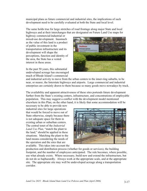
municipal plans as future commercial and industrial sites, the implications of suchdevelopment need to be carefully evaluated at both the State and local level.The same holds true for large stretches of road frontage along major State and localhighways and at their interchanges that are designated on Future <strong>Land</strong> <strong>Use</strong> maps forhighway commercial/industrial ormixed-use development. Inasmuchas the value of this land is a productof public investment in thetransportation infrastructure and itsdevelopment will shape theperceptions, function and identity ofthe area, the State has a vestedinterest in these areas.In the past 50 years, this substantialundeveloped acreage has encouragedmuch of Rhode Island’s commercialand industrial activity to move from the urban centers to the inner-ring suburbs, to benear, or nearer, the Interstate highways and airports. Large commercial and industrialenterprises are certainly drawn to them because so many goods move nowadays by truck.The availability and apparent attractiveness of these sites portends future developmentfurther from the State’s existing centers, infrastructure, and concentrations of employablepopulation. This may suggest a conflict with the development model mentionedelsewhere in this Plan; on the other hand, it is likely that some accommodation will benecessary to be able to provide newindustrial sites for large operationsthat would be forced to move out ofState otherwise, simply because thereis not adequate space for them inexisting urban or suburban centers.The central tenet of the Industrial<strong>Land</strong> <strong>Use</strong> Plan, “match the plant tothe land,” should be applied in thesesituations. Matching the plant to theland means considering the needs ofthe operation and the sites that areavailable. This takes into account theproduction and distribution process (whether for goods or services), the buildingfootprint, and the number of employees anticipated. The rule becomes, where possible,use what already exists. Where necessary, build new and extend the infrastructure, butdo not do so haphazardly. Always work at the appropriate scale, and at the appropriatesite. The appropriate site may well be undeveloped acreage along a transportationcorridor.<strong>Land</strong> <strong>Use</strong> <strong>2025</strong>: Rhode Island State <strong>Land</strong> <strong>Use</strong> Policies and Plan (April 2006)3-17
- Page 2:
The Statewide Planning Program, Rho
- Page 5:
Advisors to the Technical Committee
- Page 8 and 9:
objectives is the only way we can p
- Page 10:
In addition, there are four technic
- Page 13 and 14:
Institutional .....................
- Page 15:
LIST OF TABLESTable 121-03(1) Perce
- Page 19 and 20:
PART ONE: WHERE ARE WE AND WHERE AR
- Page 21 and 22: distinction between historic urban
- Page 23 and 24: constructed on larger lots than in
- Page 25 and 26: major pubic investments, such as re
- Page 27 and 28: and also included a continuation of
- Page 30 and 31: Geographically, the Current Trend S
- Page 33: PART TWOWHERE DO WE WANT TO BE IN 2
- Page 36 and 37: Gauging Public Perceptions of Land
- Page 38 and 39: etween the historic urban centers a
- Page 40 and 41: to provide guidance for the (vast m
- Page 42 and 43: LUO 4C: Utilize infrastructure to a
- Page 44 and 45: LUP 12: Encourage development patte
- Page 46 and 47: commercial, and institutional devel
- Page 48 and 49: comprehensive plans and supporting
- Page 50 and 51: Urban Services BoundaryAs noted pre
- Page 52 and 53: Conservation/open space-style devel
- Page 54 and 55: Narragansett Indian Tribal LandsThi
- Page 57 and 58: PART THREE: WHAT ISSUES DO WE NEED
- Page 59 and 60: need of replacement), expanded faci
- Page 61 and 62: • wastewater system design and ca
- Page 63 and 64: • Less than five percent of Rhode
- Page 65 and 66: To help address its housing needs,
- Page 67 and 68: - needs to be upgraded, the advanta
- Page 69 and 70: How This Land Use Plan Supports Sta
- Page 71: industry has resulted. Since the 19
- Page 75 and 76: The Future Land Use 2025 map identi
- Page 77 and 78: modifications, the capacity of floo
- Page 79 and 80: Restoration and maintenance of the
- Page 81 and 82: The best locations for redevelopmen
- Page 83 and 84: 3-6 Open Space and RecreationThe te
- Page 85 and 86: • How much land overall should be
- Page 87 and 88: Providence to Warwick and Wickford,
- Page 89 and 90: Another disincentive to walking and
- Page 91: Designers and the community at larg
- Page 95 and 96: PART FOUR: HOW DO WE GET THERE?4-1
- Page 97 and 98: density or medium-high density deve
- Page 99 and 100: Table 121-04(2)COMPOSITE OF FUTURE
- Page 101 and 102: This section describes the process
- Page 103 and 104: wetlands comprised about 18 percent
- Page 105 and 106: Table 121-04(5) defines the five la
- Page 107 and 108: For undeveloped areas, the analysis
- Page 109 and 110: 4-8 Scenario Analysis: Assessing Al
- Page 111 and 112: A major variable in distinguishing
- Page 113 and 114: The land need projections for the f
- Page 115 and 116: Land Use 2025: Rhode Island State L
- Page 117 and 118: Land Use 2025: Rhode Island State L
- Page 119 and 120: Table 121-04(10)QUANTITATIVE* COMPA
- Page 121 and 122: The concentration of development in
- Page 123 and 124:
4-10 Scenario SelectionIn August 20
- Page 125 and 126:
Table 121-04(12)COMPARISON OF COMPO
- Page 127:
PART FIVEWHAT MUST BE DONE TOACHIEV
- Page 130 and 131:
5-2 State InvestmentsAs noted in Pa
- Page 132 and 133:
land use plan must contain an analy
- Page 134 and 135:
Table 121-05(1)GOALS, OBJECTIVES, A
- Page 136 and 137:
Strategies12Support the participati
- Page 138 and 139:
Community DesignLeadAgenciesTimeFra
- Page 140 and 141:
7Locate small-scale convenience sho
- Page 142 and 143:
InfrastructureLeadAgenciesTimeFrame
- Page 144 and 145:
4Limit the proliferation of treatme
- Page 146 and 147:
3Coordinate transportation and land
- Page 148 and 149:
3Promote establishment of electroni
- Page 150 and 151:
AbbreviationCRMCDEMDOADOHDOTEDCGAGO
- Page 152 and 153:
Source Management Plan, State Guide
- Page 154:
41. Office of Federal Housing Enter