- Page 2:
The Statewide Planning Program, Rho
- Page 5:
Advisors to the Technical Committee
- Page 8 and 9:
objectives is the only way we can p
- Page 10:
In addition, there are four technic
- Page 13 and 14:
Institutional .....................
- Page 15:
LIST OF TABLESTable 121-03(1) Perce
- Page 19 and 20:
PART ONE: WHERE ARE WE AND WHERE AR
- Page 21 and 22:
distinction between historic urban
- Page 23 and 24:
constructed on larger lots than in
- Page 25 and 26:
major pubic investments, such as re
- Page 27 and 28:
and also included a continuation of
- Page 30 and 31:
Geographically, the Current Trend S
- Page 33:
PART TWOWHERE DO WE WANT TO BE IN 2
- Page 36 and 37:
Gauging Public Perceptions of Land
- Page 38 and 39:
etween the historic urban centers a
- Page 40 and 41:
to provide guidance for the (vast m
- Page 42 and 43:
LUO 4C: Utilize infrastructure to a
- Page 44 and 45:
LUP 12: Encourage development patte
- Page 46 and 47:
commercial, and institutional devel
- Page 48 and 49:
comprehensive plans and supporting
- Page 50 and 51:
Urban Services BoundaryAs noted pre
- Page 52 and 53:
Conservation/open space-style devel
- Page 54 and 55:
Narragansett Indian Tribal LandsThi
- Page 57 and 58:
PART THREE: WHAT ISSUES DO WE NEED
- Page 59 and 60:
need of replacement), expanded faci
- Page 61 and 62:
• wastewater system design and ca
- Page 63 and 64:
• Less than five percent of Rhode
- Page 65 and 66:
To help address its housing needs,
- Page 67 and 68:
- needs to be upgraded, the advanta
- Page 69 and 70:
How This Land Use Plan Supports Sta
- Page 71 and 72:
industry has resulted. Since the 19
- Page 73 and 74: municipal plans as future commercia
- Page 75 and 76: The Future Land Use 2025 map identi
- Page 77 and 78: modifications, the capacity of floo
- Page 79 and 80: Restoration and maintenance of the
- Page 81 and 82: The best locations for redevelopmen
- Page 83 and 84: 3-6 Open Space and RecreationThe te
- Page 85 and 86: • How much land overall should be
- Page 87 and 88: Providence to Warwick and Wickford,
- Page 89 and 90: Another disincentive to walking and
- Page 91: Designers and the community at larg
- Page 95 and 96: PART FOUR: HOW DO WE GET THERE?4-1
- Page 97 and 98: density or medium-high density deve
- Page 99 and 100: Table 121-04(2)COMPOSITE OF FUTURE
- Page 101 and 102: This section describes the process
- Page 103 and 104: wetlands comprised about 18 percent
- Page 105 and 106: Table 121-04(5) defines the five la
- Page 107 and 108: For undeveloped areas, the analysis
- Page 109 and 110: 4-8 Scenario Analysis: Assessing Al
- Page 111 and 112: A major variable in distinguishing
- Page 113 and 114: The land need projections for the f
- Page 115 and 116: Land Use 2025: Rhode Island State L
- Page 117 and 118: Land Use 2025: Rhode Island State L
- Page 119 and 120: Table 121-04(10)QUANTITATIVE* COMPA
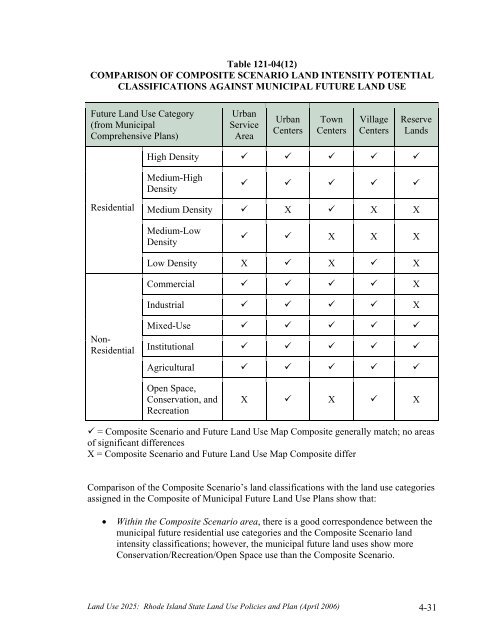
- Page 121 and 122: The concentration of development in
- Page 123: 4-10 Scenario SelectionIn August 20
- Page 127: PART FIVEWHAT MUST BE DONE TOACHIEV
- Page 130 and 131: 5-2 State InvestmentsAs noted in Pa
- Page 132 and 133: land use plan must contain an analy
- Page 134 and 135: Table 121-05(1)GOALS, OBJECTIVES, A
- Page 136 and 137: Strategies12Support the participati
- Page 138 and 139: Community DesignLeadAgenciesTimeFra
- Page 140 and 141: 7Locate small-scale convenience sho
- Page 142 and 143: InfrastructureLeadAgenciesTimeFrame
- Page 144 and 145: 4Limit the proliferation of treatme
- Page 146 and 147: 3Coordinate transportation and land
- Page 148 and 149: 3Promote establishment of electroni
- Page 150 and 151: AbbreviationCRMCDEMDOADOHDOTEDCGAGO
- Page 152 and 153: Source Management Plan, State Guide
- Page 154: 41. Office of Federal Housing Enter