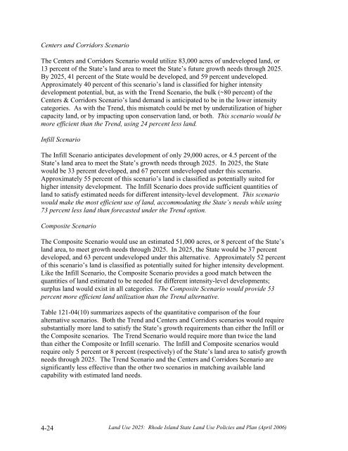
Centers and Corridors ScenarioThe Centers and Corridors Scenario would utilize 83,000 acres of undeveloped land, or13 percent of the State’s land area to meet the State’s future growth needs through <strong>2025</strong>.By <strong>2025</strong>, 41 percent of the State would be developed, and 59 percent undeveloped.Approximately 40 percent of this scenario’s land is classified for higher intensitydevelopment potential, but, as with the Trend Scenario, the bulk (~80 percent) of theCenters & Corridors Scenario’s land demand is anticipated to be in the lower intensitycategories. As with the Trend, this mismatch could be met by underutilization of highercapacity land, or by impacting upon conservation land, or both. This scenario would bemore efficient than the Trend, using 24 percent less land.Infill ScenarioThe Infill Scenario anticipates development of only 29,000 acres, or 4.5 percent of theState’s land area to meet the State’s growth needs through <strong>2025</strong>. In <strong>2025</strong>, the Statewould be 33 percent developed, and 67 percent undeveloped under this scenario.Approximately 55 percent of this scenario’s land is classified as potentially suited forhigher intensity development. The Infill Scenario does provide sufficient quantities ofland to satisfy estimated needs for different intensity-level development. This scenariowould make the most efficient use of land, accommodating the State’s needs while using73 percent less land than forecasted under the Trend option.Composite ScenarioThe Composite Scenario would use an estimated 51,000 acres, or 8 percent of the State’sland area, to meet growth needs through <strong>2025</strong>. In <strong>2025</strong>, the State would be 37 percentdeveloped, and 63 percent undeveloped under this alternative. Approximately 52 percentof this scenario’s land is classified as potentially suited for higher intensity development.Like the Infill Scenario, the Composite Scenario provides a good match between thequantities of land estimated to be needed for different intensity-level developments;surplus land would exist in all categories. The Composite Scenario would provide 53percent more efficient land utilization than the Trend alternative.Table 121-04(10) summarizes aspects of the quantitative comparison of the fouralternative scenarios. Both the Trend and Centers and Corridors scenarios would requiresubstantially more land to satisfy the State’s growth requirements than either the Infill orthe Composite scenarios. The Trend Scenario would require more than twice the landthan either the Composite or Infill scenario. The Infill and Composite scenarios wouldrequire only 5 percent or 8 percent (respectively) of the State’s land area to satisfy growthneeds through <strong>2025</strong>. The Trend Scenario and the Centers and Corridors Scenario aresignificantly less effective than the other two scenarios in matching available landcapability with estimated land needs.4-24<strong>Land</strong> <strong>Use</strong> <strong>2025</strong>: Rhode Island State <strong>Land</strong> <strong>Use</strong> Policies and Plan (April 2006)
Table 121-04(10)QUANTITATIVE* COMPA<strong>RI</strong>SON OF FUTURE LAND USE SCENA<strong>RI</strong>OSAcresTrendCenters &CorridorsInfillCompositeTotal land area of State 638,000 638,000 638,000 638,000Existing developed land (1995) 205,000 205,000 205,000 205,000Additional land estimated to beneeded for new development through<strong>2025</strong>Total estimated developed acres* in<strong>2025</strong>Total estimated undeveloped acres*in <strong>2025</strong>Net uncommitted, developable landremaining in <strong>2025</strong>Percent <strong>Land</strong> AreaTotal land area of State (~638,000acres)Minus existing (1995) developedland** (~205,000 acres)Net undeveloped land area of State(1995)Additional land estimated to beneeded for new development through<strong>2025</strong>Percentage of State area developed in<strong>2025</strong>Percentage of State area undevelopedin <strong>2025</strong>Net uncommitted, developable landremaining in <strong>2025</strong>109,000 83,000 29,000 51,000314,000 288,000 234,000 256,000386,000 412,000 466,000 444,000183,000 209,000 263,000 241,000TrendCenters &CorridorsInfillComposite100 100 100 10032 32 32 3268 68 68 6817 13 5 849 45 37 4051 55 63 6029 33 41 38* Acres (rounded to nearest thousand)** Developed <strong>Land</strong> includes some “protected land” as parks & active recreation<strong>Land</strong> <strong>Use</strong> <strong>2025</strong>: Rhode Island State <strong>Land</strong> <strong>Use</strong> Policies and Plan (April 2006) 4-25
- Page 2:
The Statewide Planning Program, Rho
- Page 5:
Advisors to the Technical Committee
- Page 8 and 9:
objectives is the only way we can p
- Page 10:
In addition, there are four technic
- Page 13 and 14:
Institutional .....................
- Page 15:
LIST OF TABLESTable 121-03(1) Perce
- Page 19 and 20:
PART ONE: WHERE ARE WE AND WHERE AR
- Page 21 and 22:
distinction between historic urban
- Page 23 and 24:
constructed on larger lots than in
- Page 25 and 26:
major pubic investments, such as re
- Page 27 and 28:
and also included a continuation of
- Page 30 and 31:
Geographically, the Current Trend S
- Page 33:
PART TWOWHERE DO WE WANT TO BE IN 2
- Page 36 and 37:
Gauging Public Perceptions of Land
- Page 38 and 39:
etween the historic urban centers a
- Page 40 and 41:
to provide guidance for the (vast m
- Page 42 and 43:
LUO 4C: Utilize infrastructure to a
- Page 44 and 45:
LUP 12: Encourage development patte
- Page 46 and 47:
commercial, and institutional devel
- Page 48 and 49:
comprehensive plans and supporting
- Page 50 and 51:
Urban Services BoundaryAs noted pre
- Page 52 and 53:
Conservation/open space-style devel
- Page 54 and 55:
Narragansett Indian Tribal LandsThi
- Page 57 and 58:
PART THREE: WHAT ISSUES DO WE NEED
- Page 59 and 60:
need of replacement), expanded faci
- Page 61 and 62:
• wastewater system design and ca
- Page 63 and 64:
• Less than five percent of Rhode
- Page 65 and 66:
To help address its housing needs,
- Page 67 and 68: - needs to be upgraded, the advanta
- Page 69 and 70: How This Land Use Plan Supports Sta
- Page 71 and 72: industry has resulted. Since the 19
- Page 73 and 74: municipal plans as future commercia
- Page 75 and 76: The Future Land Use 2025 map identi
- Page 77 and 78: modifications, the capacity of floo
- Page 79 and 80: Restoration and maintenance of the
- Page 81 and 82: The best locations for redevelopmen
- Page 83 and 84: 3-6 Open Space and RecreationThe te
- Page 85 and 86: • How much land overall should be
- Page 87 and 88: Providence to Warwick and Wickford,
- Page 89 and 90: Another disincentive to walking and
- Page 91: Designers and the community at larg
- Page 95 and 96: PART FOUR: HOW DO WE GET THERE?4-1
- Page 97 and 98: density or medium-high density deve
- Page 99 and 100: Table 121-04(2)COMPOSITE OF FUTURE
- Page 101 and 102: This section describes the process
- Page 103 and 104: wetlands comprised about 18 percent
- Page 105 and 106: Table 121-04(5) defines the five la
- Page 107 and 108: For undeveloped areas, the analysis
- Page 109 and 110: 4-8 Scenario Analysis: Assessing Al
- Page 111 and 112: A major variable in distinguishing
- Page 113 and 114: The land need projections for the f
- Page 115 and 116: Land Use 2025: Rhode Island State L
- Page 117: Land Use 2025: Rhode Island State L
- Page 121 and 122: The concentration of development in
- Page 123 and 124: 4-10 Scenario SelectionIn August 20
- Page 125 and 126: Table 121-04(12)COMPARISON OF COMPO
- Page 127: PART FIVEWHAT MUST BE DONE TOACHIEV
- Page 130 and 131: 5-2 State InvestmentsAs noted in Pa
- Page 132 and 133: land use plan must contain an analy
- Page 134 and 135: Table 121-05(1)GOALS, OBJECTIVES, A
- Page 136 and 137: Strategies12Support the participati
- Page 138 and 139: Community DesignLeadAgenciesTimeFra
- Page 140 and 141: 7Locate small-scale convenience sho
- Page 142 and 143: InfrastructureLeadAgenciesTimeFrame
- Page 144 and 145: 4Limit the proliferation of treatme
- Page 146 and 147: 3Coordinate transportation and land
- Page 148 and 149: 3Promote establishment of electroni
- Page 150 and 151: AbbreviationCRMCDEMDOADOHDOTEDCGAGO
- Page 152 and 153: Source Management Plan, State Guide
- Page 154: 41. Office of Federal Housing Enter