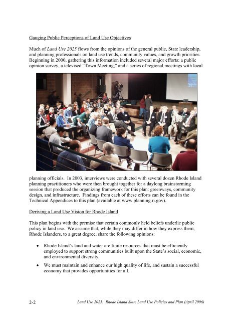
Gauging Public Perceptions of <strong>Land</strong> <strong>Use</strong> ObjectivesMuch of <strong>Land</strong> <strong>Use</strong> <strong>2025</strong> flows from the opinions of the general public, State leadership,and planning professionals on land use trends, community values, and growth priorities.Beginning in 2000, gathering this information included several major efforts: a publicopinion survey, a televised “Town Meeting,” and a series of regional meetings with localplanning officials. In 2003, interviews were conducted with several dozen Rhode Islandplanning practitioners who were then brought together for a daylong brainstormingsession that produced the organizing framework for this plan: greenways, communitydesign, and infrastructure. Findings from each of these efforts can be found in theTechnical Appendices to this plan (available at www.planning.ri.gov).Deriving a <strong>Land</strong> <strong>Use</strong> Vision for Rhode IslandThis plan begins with the premise that certain commonly held beliefs underlie publicpolicy in land use. We assume that, while they may differ in how they express them,Rhode Islanders, to a great degree, share the following opinions:• Rhode Island’s land and water are finite resources that must be efficientlyemployed to support strong communities built upon the State’s social, economic,and environmental diversity.• We must maintain and enhance our high quality of life, and sustain a successfuleconomy that provides opportunities for all.2-2 <strong>Land</strong> <strong>Use</strong> <strong>2025</strong>: Rhode Island State <strong>Land</strong> <strong>Use</strong> Policies and Plan (April 2006)
• No single purpose, sector, or entity can shape a successful land use future alone.It must be created by an alliance of governments, business, and the publicworking in concert toward shared goals.Beyond these basic concepts, land use professionals have developed detailed technicaland strategic policies that are also fundamental to <strong>Land</strong> <strong>Use</strong> <strong>2025</strong>. These would shapefuture land use in Rhode Island to achieve vibrant community centers and neighborhoods,a pervasive greenspace network, revitalized urban centers, the containment of sprawl,quality design in development, and effective stewardship of all resources.Several State documents have articulated visions for land use in Rhode Island, extolledthe values of certain resources, or offered descriptions of what we would like the State tobe. For example, State Guide Plan Element 155, A Greener Path: Greenspace andGreenways for Rhode Island’s Future established a greenspace vision in 1994. Thissystem of greenspace was also described in State Guide Plan 152, Ocean State Outdoors:Rhode Island’s Comprehensive Outdoor Recreation Plan in 2003:A statewide system of connecting greenspaces and greenways, a networkmade up of critical natural and cultural resources, outdoor recreationfacilities, public space, community and urban forests, public and privateopen spaces. The greenspace system is to be Rhode Island’s permanentgreen framework within which the State’s communities will design andbuild in the 21st century.Concentrating land uses in well-designed community centers is a tenet of good planningand a basic recommendation of both the 1975 and 1989 State <strong>Land</strong> <strong>Use</strong> Plans. Morerecently, beginning in 2000, the Governor’s Growth Planning Council launched aninitiative to promote growth centers by recommending the adoption of a State investmentstrategy that would act as an incentive. This investment strategy would prioritize Statediscretionary investments (to include State managed federal funds) as well as technicalassistance and expedited regulatory review to locally designated and State approvedcenters. Growth centers are defined as having “a core of commercial and communityservices, residential development, and natural and built landmarks and boundaries thatprovide a sense of place,” making them dynamic and efficient centers for development.The importance of “the power of place” – the relationship between quality of place andquality of life – and the importance of successful land use strategies to preserve them areincreasingly recognized as strategic tools for economic well-being. The Rhode IslandEconomic Policy Council and others have extolled the potential of the State’s “rich mixof authentic places” to attract or retain the young and the talented, people who cancontribute much to the economy if they settle here.An “Urban/Rural” Systems ApproachWhen examined on the broadest scale, for example from a map of the State, a strikingcharacteristic of Rhode Island’s land use pattern is that it retains a strong distinction<strong>Land</strong> <strong>Use</strong> <strong>2025</strong>: Rhode Island State <strong>Land</strong> <strong>Use</strong> Policies and Plan (April 2006) 2-3
- Page 2: The Statewide Planning Program, Rho
- Page 5: Advisors to the Technical Committee
- Page 8 and 9: objectives is the only way we can p
- Page 10: In addition, there are four technic
- Page 13 and 14: Institutional .....................
- Page 15: LIST OF TABLESTable 121-03(1) Perce
- Page 19 and 20: PART ONE: WHERE ARE WE AND WHERE AR
- Page 21 and 22: distinction between historic urban
- Page 23 and 24: constructed on larger lots than in
- Page 25 and 26: major pubic investments, such as re
- Page 27 and 28: and also included a continuation of
- Page 30 and 31: Geographically, the Current Trend S
- Page 33: PART TWOWHERE DO WE WANT TO BE IN 2
- Page 38 and 39: etween the historic urban centers a
- Page 40 and 41: to provide guidance for the (vast m
- Page 42 and 43: LUO 4C: Utilize infrastructure to a
- Page 44 and 45: LUP 12: Encourage development patte
- Page 46 and 47: commercial, and institutional devel
- Page 48 and 49: comprehensive plans and supporting
- Page 50 and 51: Urban Services BoundaryAs noted pre
- Page 52 and 53: Conservation/open space-style devel
- Page 54 and 55: Narragansett Indian Tribal LandsThi
- Page 57 and 58: PART THREE: WHAT ISSUES DO WE NEED
- Page 59 and 60: need of replacement), expanded faci
- Page 61 and 62: • wastewater system design and ca
- Page 63 and 64: • Less than five percent of Rhode
- Page 65 and 66: To help address its housing needs,
- Page 67 and 68: - needs to be upgraded, the advanta
- Page 69 and 70: How This Land Use Plan Supports Sta
- Page 71 and 72: industry has resulted. Since the 19
- Page 73 and 74: municipal plans as future commercia
- Page 75 and 76: The Future Land Use 2025 map identi
- Page 77 and 78: modifications, the capacity of floo
- Page 79 and 80: Restoration and maintenance of the
- Page 81 and 82: The best locations for redevelopmen
- Page 83 and 84: 3-6 Open Space and RecreationThe te
- Page 85 and 86: • How much land overall should be
- Page 87 and 88:
Providence to Warwick and Wickford,
- Page 89 and 90:
Another disincentive to walking and
- Page 91:
Designers and the community at larg
- Page 95 and 96:
PART FOUR: HOW DO WE GET THERE?4-1
- Page 97 and 98:
density or medium-high density deve
- Page 99 and 100:
Table 121-04(2)COMPOSITE OF FUTURE
- Page 101 and 102:
This section describes the process
- Page 103 and 104:
wetlands comprised about 18 percent
- Page 105 and 106:
Table 121-04(5) defines the five la
- Page 107 and 108:
For undeveloped areas, the analysis
- Page 109 and 110:
4-8 Scenario Analysis: Assessing Al
- Page 111 and 112:
A major variable in distinguishing
- Page 113 and 114:
The land need projections for the f
- Page 115 and 116:
Land Use 2025: Rhode Island State L
- Page 117 and 118:
Land Use 2025: Rhode Island State L
- Page 119 and 120:
Table 121-04(10)QUANTITATIVE* COMPA
- Page 121 and 122:
The concentration of development in
- Page 123 and 124:
4-10 Scenario SelectionIn August 20
- Page 125 and 126:
Table 121-04(12)COMPARISON OF COMPO
- Page 127:
PART FIVEWHAT MUST BE DONE TOACHIEV
- Page 130 and 131:
5-2 State InvestmentsAs noted in Pa
- Page 132 and 133:
land use plan must contain an analy
- Page 134 and 135:
Table 121-05(1)GOALS, OBJECTIVES, A
- Page 136 and 137:
Strategies12Support the participati
- Page 138 and 139:
Community DesignLeadAgenciesTimeFra
- Page 140 and 141:
7Locate small-scale convenience sho
- Page 142 and 143:
InfrastructureLeadAgenciesTimeFrame
- Page 144 and 145:
4Limit the proliferation of treatme
- Page 146 and 147:
3Coordinate transportation and land
- Page 148 and 149:
3Promote establishment of electroni
- Page 150 and 151:
AbbreviationCRMCDEMDOADOHDOTEDCGAGO
- Page 152 and 153:
Source Management Plan, State Guide
- Page 154:
41. Office of Federal Housing Enter