Housing Needs Assessment 2006 - Westminster City Council
Housing Needs Assessment 2006 - Westminster City Council
Housing Needs Assessment 2006 - Westminster City Council
- No tags were found...

You also want an ePaper? Increase the reach of your titles
YUMPU automatically turns print PDFs into web optimized ePapers that Google loves.
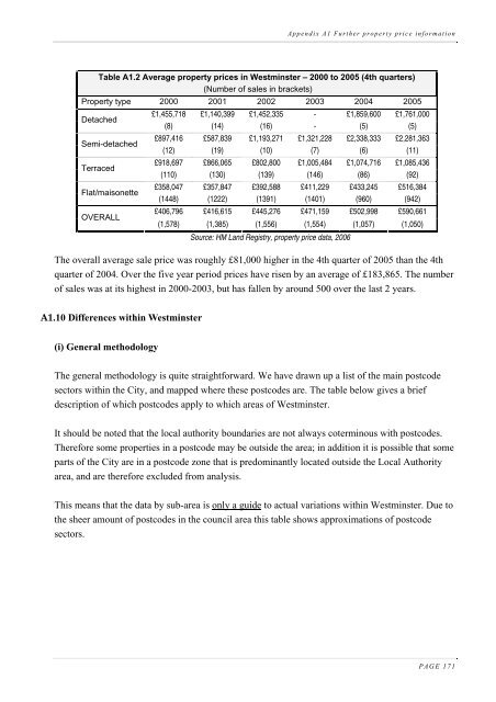
Appendix A1 Further property price informationTable A1.2 Average property prices in <strong>Westminster</strong> – 2000 to 2005 (4th quarters)(Number of sales in brackets)Property type 2000 2001 2002 2003 2004 2005DetachedSemi-detachedTerracedFlat/maisonetteOVERALL£1,455,718 £1,140,399 £1,452,335 - £1,859,600 £1,761,000(8) (14) (16) - (5) (5)£897,416 £587,839 £1,193,271 £1,321,228 £2,338,333 £2,281,363(12) (19) (10) (7) (6) (11)£918,697 £866,065 £802,800 £1,005,484 £1,074,716 £1,085,436(110) (130) (139) (146) (86) (92)£358,047 £357,847 £392,588 £411,229 £433,245 £516,384(1448) (1222) (1391) (1401) (960) (942)£406,796 £416,615 £445,276 £471,159 £502,998 £590,661(1,578) (1,385) (1,556) (1,554) (1,057) (1,050)Source: HM Land Registry, property price data, <strong>2006</strong>The overall average sale price was roughly £81,000 higher in the 4th quarter of 2005 than the 4thquarter of 2004. Over the five year period prices have risen by an average of £183,865. The numberof sales was at its highest in 2000-2003, but has fallen by around 500 over the last 2 years.A1.10 Differences within <strong>Westminster</strong>(i) General methodologyThe general methodology is quite straightforward. We have drawn up a list of the main postcodesectors within the <strong>City</strong>, and mapped where these postcodes are. The table below gives a briefdescription of which postcodes apply to which areas of <strong>Westminster</strong>.It should be noted that the local authority boundaries are not always coterminous with postcodes.Therefore some properties in a postcode may be outside the area; in addition it is possible that someparts of the <strong>City</strong> are in a postcode zone that is predominantly located outside the Local Authorityarea, and are therefore excluded from analysis.This means that the data by sub-area is only a guide to actual variations within <strong>Westminster</strong>. Due tothe sheer amount of postcodes in the council area this table shows approximations of postcodesectors.PAGE 171