- Page 1 and 2:
FOCAL MECHANISMS AND VARIATIONS IN
- Page 3:
Acknowledgements:I would like to ex
- Page 9 and 10:
Figure 5.12: Summary of the focal m
- Page 11 and 12:
AbbreviationsCNSN: Canadian Nationa
- Page 13 and 14:
Earthquakes in western Quebec and s
- Page 15 and 16:
1.2 Organization of ThesisChapter 1
- Page 17 and 18:
eastern Canada each year, of which
- Page 19 and 20:
Metasedimentary Belt boundary tecto
- Page 21 and 22:
The Grenville Front tectonic zone (
- Page 23 and 24:
Figure 2.3: Seismicity in the study
- Page 25 and 26:
oadly similar continent-continent c
- Page 27 and 28:
Figure 2.4: Historical earthquakes
- Page 29 and 30:
earthquakes have occurred within th
- Page 31 and 32:
cluster, which is considered part o
- Page 33 and 34:
2001. All events seemed to occur in
- Page 35 and 36:
CHAPTER 3DATA SET AND METHODS3.1 In
- Page 37 and 38:
Fig. 3.1: Locations of seismic stat
- Page 39 and 40:
Figure 3.2: Number of stations used
- Page 41 and 42:
the strongest recorded event in the
- Page 43 and 44:
Figure 3.5: Earthquake source param
- Page 45 and 46:
The amplitudes of the seismic waves
- Page 47 and 48:
Figure 3.7: Vertical component wave
- Page 49 and 50:
HYPOCENTER programThe HYPOCENTER pr
- Page 51 and 52:
wave - e.g. Pg or Pn, Sg or Sn), th
- Page 53 and 54:
model for P-wave velocity with mult
- Page 55 and 56: CHAPTER 4RESULTSIn this chapter the
- Page 57 and 58: Figure 4.1: Distribution of RMS of
- Page 59 and 60: Table 4.2: Earthquake parameters (h
- Page 61 and 62: The focal depth calculated here is
- Page 63 and 64: focal mechanism beach-ball diagrams
- Page 65 and 66: some spatial variability of the ori
- Page 67 and 68: 22 20001006 50 ±3 134 ±10 90 ±0
- Page 69 and 70: a)b)c)d)Western QuebecSouthern Onta
- Page 71 and 72: esults from other similar studies,
- Page 73 and 74: source region (e.g. Chen and Molnar
- Page 75 and 76: estimate using a stress inversion t
- Page 77 and 78: Figure 5.3: Stress pattern for all
- Page 79 and 80: oundaries of the Central Metasedime
- Page 81 and 82: In Western Quebec Seizmic Zone (WQS
- Page 83 and 84: deeper than 20 km (20 km to 26 km).
- Page 85 and 86: Figure 5.7: Geologic features of WQ
- Page 87 and 88: 2009). The Mont-Laurier earthquake
- Page 89 and 90: a) b)c) d)Figure 5.9: Summary of th
- Page 91 and 92: 5.4.3 Adirondack Clusters (WQ4 and
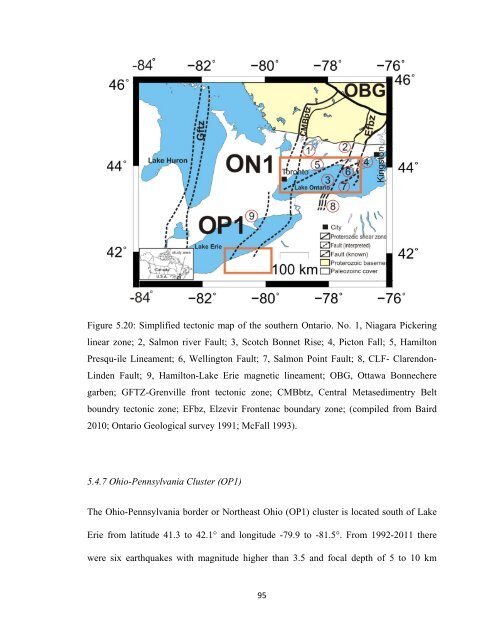
- Page 93 and 94: WQ5 is located in the southern part
- Page 95 and 96: Figure 5.13: Geological features of
- Page 97 and 98: consistent with regional fault map
- Page 99 and 100: WQ8 is locatedin the north-western
- Page 101 and 102: 5.4.5 Timiskaming Cluster (WQ9)The
- Page 103 and 104: The known faults in WQ9 cluster are
- Page 105: a) b)c) d)Figure 5.19: Summary of t
- Page 109 and 110: Figure 5.22: Nodal plane strike for
- Page 111 and 112: estricted to western Lake Ontario o
- Page 113 and 114: More detailed look at the relations
- Page 115 and 116: Baird, W.A. F., and McKinnon, S. D.
- Page 117 and 118: Easton, R. M. (1986). Geochronology
- Page 119 and 120: Havskov, J., and Ottemöller, L. (2
- Page 121 and 122: Ma, S., and Adams, J. (2002). Estim
- Page 123 and 124: Rimando, R. E., and Benn, K. (2005)
- Page 125 and 126: Wahlstrom, R. (1987) Focal mechanis
- Page 127 and 128: APPENDIX A: Examples of Input and O
- Page 129 and 130: SUNO BZ SN 3 141 15.29SADO BZ SG 4
- Page 131 and 132: EEO BZ SG 4 140 48.02 91 0.09 0 315
- Page 133 and 134: PAL BZ PN 2 D 140 33.20 53 -0.21 1
- Page 135 and 136: APPENDIX C: Faults Plane Solutions
- Page 137 and 138: 126
- Page 139 and 140: 128
- Page 141 and 142: 130
- Page 143 and 144: 132
- Page 145 and 146: 134
- Page 147 and 148: 136
- Page 149 and 150: 138
- Page 151 and 152: 140
- Page 153 and 154: 142
- Page 155 and 156: 144
- Page 157 and 158:
146
- Page 159 and 160:
148
- Page 161 and 162:
150
- Page 163 and 164:
152
- Page 165 and 166:
154
- Page 167 and 168:
156
- Page 169 and 170:
158
- Page 171 and 172:
Appendix D: Focal Mechanisms From P
- Page 173 and 174:
19810707 -74.6 45.1 13.0 1.9 304.0
- Page 175 and 176:
19950603 -76.4 47.1 18.0 3.9 100.1
- Page 177 and 178:
20060225 -75.2 45.7 18.7 4.5 125.8
- Page 179 and 180:
168
- Page 181 and 182:
170
- Page 183 and 184:
172
- Page 185 and 186:
174
- Page 187 and 188:
176