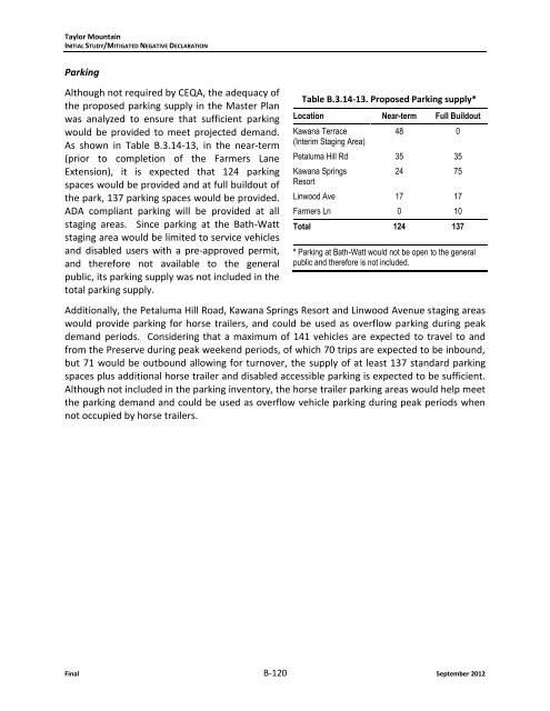
Taylor MountainINITIAL STUDY/MITIGATED NEGATIVE DECLARATIONParkingAlthough not required by CEQA, the adequacy ofthe proposed parking supply in the Master Planwas analyzed to ensure that sufficient parkingwould be provided to meet projected dem<strong>and</strong>.As shown in Table B.3.14-13, in the near-term(prior to completion of the Farmers LaneExtension), it is expected that 124 parkingspaces would be provided <strong>and</strong> at full buildout ofthe park, 137 parking spaces would be provided.ADA compliant parking will be provided at allstaging areas. Since parking at the Bath-Wattstaging area would be limited to service vehicles<strong>and</strong> disabled users with a pre-approved permit,<strong>and</strong> therefore not available to the generalpublic, its parking supply was not included in thetotal parking supply.Table B.3.14-13. Proposed Parking supply*Location Near-term Full BuildoutKawana Terrace(Interim Staging Area)48 0Petaluma Hill Rd 35 35Kawana SpringsResort24 75Linwood Ave 17 17Farmers Ln 0 10Total 124 137* Parking at Bath-Watt would not be open to the generalpublic <strong>and</strong> therefore is not included.Additionally, the Petaluma Hill Road, Kawana Springs Resort <strong>and</strong> Linwood Avenue staging areaswould provide parking for horse trailers, <strong>and</strong> could be used as overflow parking during peakdem<strong>and</strong> periods. Considering that a maximum of 141 vehicles are expected to travel to <strong>and</strong>from the Preserve during peak weekend periods, of which 70 trips are expected to be inbound,but 71 would be outbound allowing for turnover, the supply of at least 137 st<strong>and</strong>ard parkingspaces plus additional horse trailer <strong>and</strong> disabled accessible parking is expected to be sufficient.Although not included in the parking inventory, the horse trailer parking areas would help meetthe parking dem<strong>and</strong> <strong>and</strong> could be used as overflow vehicle parking during peak periods whennot occupied by horse trailers.Final B-120 September 2012
Taylor MountainINITIAL STUDY/MITIGATED NEGATIVE DECLARATIONB.3.15 Utilities <strong>and</strong> Service SystemsUTILITIES AND SERVICE SYSTEMSWould the project:a. Exceed wastewater treatment requirements of the applicableRegional Water Quality Control Board?PotentiallySignificantImpactLess thanSignificantWithMitigationIncorporatedLess thanSignificantImpactNo Impactb. Require or result in the construction of new water or wastewatertreatment facilities or expansion of existing facilities, the constructionof which could cause significant environmental effects?c. Require or result in the construction of new storm water drainagefacilities or expansion of existing facilities, the construction ofwhich could cause significant environmental effects?d. Have sufficient water supplies available to serve the project fromexisting entitlements <strong>and</strong> resources, or are new or exp<strong>and</strong>edentitlements needed?e. Result in a determination by the wastewater treatment providerwhich serves or may serve the project that it has adequatecapacity to serve the project’s projected dem<strong>and</strong> in addition tothe provider’s existing commitments?f. Be served by a l<strong>and</strong>fill with sufficient permitted capacity toaccommodate the project’s solid waste disposal needs?g. Comply with federal, state, <strong>and</strong> local statutes <strong>and</strong> regulationsrelated to solid waste?Significance criteria based on CEQA Guidelines, Appendix G.B.3.15.1 SettingThis section addresses water supply, wastewater, stormwater, <strong>and</strong> solid waste. Additionalinformation regarding stormwater drainage is provided in Section B.3.8, Hydrology. The TaylorMountain Preserve property is outside of the City of Santa Rosa’s city limits, urban growthboundary, urban services boundary <strong>and</strong> Sphere of Influence (SOI). The northern propertyboundary abuts the urban services, urban growth <strong>and</strong> SOI boundaries. Because the majority ofthe property is outside of the urban services area, it is not served by public services (e.g., watersupply, sewer hookup <strong>and</strong> stormwater infrastructure). The northern section of property off ofPanorama Drive (Bath-Watt parcel) <strong>and</strong> the Linwood Avenue parcel are within the City’s UrbanServices area, but there is no plan to pursue City services in these locations. The property hasonsite springs <strong>and</strong> wells. The existing residence is served by a springs <strong>and</strong> septic system. Theexisting portable toilet that serves recreational visitors is serviced by the Regional ParksDepartment.On the <strong>Sonoma</strong> <strong>County</strong> groundwater availability map (<strong>Sonoma</strong> <strong>County</strong>, 2004), the entireproperty is shown as Zone 3 – limited groundwater area. However, given the presence ofsprings <strong>and</strong> a well on the property, <strong>and</strong> existing <strong>and</strong> historic use of the onsite aquifer fordomestic <strong>and</strong> commercial purposes, there are likely areas within the 1,100 acres that havegroundwater potential for additional well development. As described in the hydrology section,the aquifer appears to be shallow, as indicated by springs <strong>and</strong> associated wetl<strong>and</strong>s on theproperty.September 2012 B-121 Final